| Mesoscale Discussion 214 | |
| < Previous MD Next MD > | |

|
|
Mesoscale Discussion 0214
NWS Storm Prediction Center Norman OK
1015 AM CDT Wed Mar 11 2026
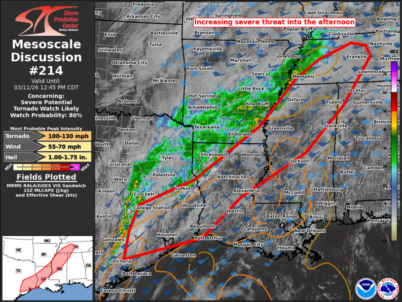
Areas affected...southeast TX to middle TN
Concerning...Severe potential...Tornado Watch likely
Valid 111515Z - 111745Z
Probability of Watch Issuance...80 percent
SUMMARY...An increasing severe threat is expected into this
afternoon. Multiple tornado watches will likely be needed towards
midday/early afternoon from the northwest Gulf Coast to the
Tennessee Valley.
DISCUSSION...An extensive swath of broken convection is ongoing from
parts of southeast TX into the Ark-La-Miss/Mid-South vicinity. Cloud
breaks ahead of this activity are aiding in gradual airmass
destabilization from MS southwestward, where moderate MLCAPE from
1000-2000 J/kg should become pervasive over the next few hours.
Most prominent severe threat is anticipated to emanate out of the
southeast TX vicinity, where a combination of steeper mid-level
lapse rates/greater boundary-layer heating, coupled with
stronger/slightly more backed low-level flow should aid in
strengthening of a QLCS this afternoon. Embedded supercell
structures are expected, yielding a threat for a few tornadoes, with
a strong one possible.
Farther northeast, weaker instability and more line-parallel
deep-layer flow may support less coverage/amplitude of severe
initially. But pre-outflow confluence bands across central to
northeast MS may aid in supercell formation deeper into the
afternoon over the TN Valley as the large-scale outflow approaches.
..Grams/Gleason.. 03/11/2026
...Please see www.spc.noaa.gov for graphic product...
ATTN...WFO...OHX...BMX...HUN...MEG...JAN...LZK...LCH...SHV...
HGX...
LAT...LON 29979640 30859607 31759395 33589136 35138990 35828889
36338752 36228691 35858674 34248794 32678951 31199210
29819358 28999654 29979640
MOST PROBABLE PEAK TORNADO INTENSITY...100-130 MPH
MOST PROBABLE PEAK WIND GUST...55-70 MPH
MOST PROBABLE PEAK HAIL SIZE...1.00-1.75 IN
|
|
|
Top/All Mesoscale Discussions/Forecast Products/Home |
|
Source link