| Mesoscale Discussion 177 | |
| < Previous MD | |

|
|
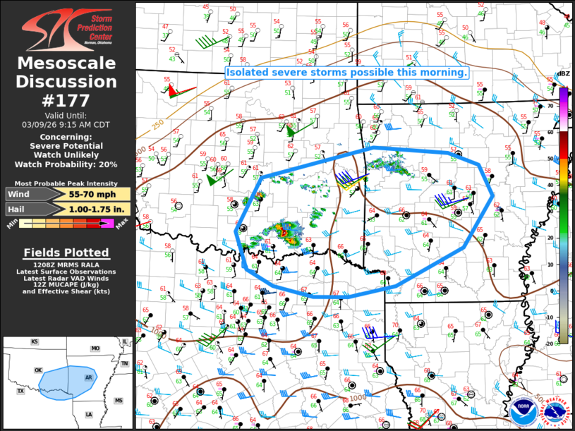
   Mesoscale Discussion 0177
   NWS Storm Prediction Center Norman OK
   0710 AM CDT Mon Mar 09 2026

   Areas affected...Parts of southeast OK/northeast TX into AR and far
   northwest LA

   Concerning...Severe potential...Watch unlikely

   Valid 091210Z - 091415Z

   Probability of Watch Issuance...20 percent

   SUMMARY...Isolated severe storms are possible this morning.

   DISCUSSION...Elevated convection has developed across parts of
   south-central/southeast OK this morning, within a low-level
   warm-advection regime and in advance of a low-amplitude midlevel
   shortwave trough moving across OK. Increasing moisture in the
   850-700 mb layer beneath relatively steep midlevel lapse rates is
   resulting in MUCAPE values of greater than 1000 J/kg from north TX
   into AR, which will aid in the development of potentially robust
   updrafts. Coverage of storms through mid morning remains somewhat
   uncertain, due to the only modest large-scale ascent associated with
   the weakening shortwave trough. However, moderate mid/upper-level
   flow will support sufficient effective shear for some storm
   organization, with any sustained robust updrafts becoming capable of
   producing large hail and locally gusty winds.

   Watch issuance is considered unlikely in the short term, with the
   expectation that the severe threat will generally remain isolated
   through mid morning. Greater severe potential is still expected from
   late morning into the afternoon across parts of AR/MS, when
   surface-based destabilization becomes more supportive of organized
   cells and/or clusters.

   ..Dean/Mosier.. 03/09/2026

   ...Please see www.spc.noaa.gov for graphic product...

   ATTN...WFO...LZK...SHV...TSA...FWD...OUN...

   LAT...LON   35199666 35749427 35639267 35409202 34869173 33969238
               33309381 33119480 33129553 33309636 33579692 34239717
               35199666

   MOST PROBABLE PEAK WIND GUST...55-70 MPH
   MOST PROBABLE PEAK HAIL SIZE...1.00-1.75 IN
|
|
|
Top/All Mesoscale Discussions/Forecast Products/Home |
|
Source link