| Mesoscale Discussion 175 | |
| < Previous MD | |

|
|
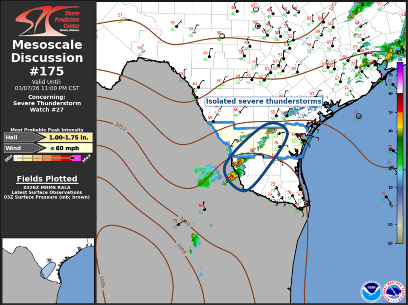
Mesoscale Discussion 0175 NWS Storm Prediction Center Norman OK 0929 PM CST Sat Mar 07 2026 Areas affected...Deep South Texas Concerning...Severe Thunderstorm Watch 27... Valid 080329Z - 080500Z The severe weather threat for Severe Thunderstorm Watch 27 continues. SUMMARY...Isolated severe thunderstorms remain possible across deep South Texas the next few hours. New severe thunderstorm watch is not anticipated. DISCUSSION...Surface front continues sagging south across deep South TX with the boundary now extending from Jim Wells to Zapata County. Most of the stronger elevated convection has weakened or dissipated, but isolated strong/severe thunderstorms are now focused along the wind shift across this region. Latest radar data suggests the strongest updrafts are just across the Rio Grande river over northeast Mexico, and this activity is likely only producing hail near 1 inch in diameter. Loss of heating will likely result in gradual weakening of this activity and a new watch is not anticipated. ..Darrow.. 03/08/2026 ...Please see www.spc.noaa.gov for graphic product... ATTN...WFO...CRP...BRO... LAT...LON 27029965 28119846 27919777 27109827 26359906 27029965 MOST PROBABLE PEAK WIND GUST...UP TO 60 MPH MOST PROBABLE PEAK HAIL SIZE...1.00-1.75 IN |
|
|
Top/All Mesoscale Discussions/Forecast Products/Home |
|
Source link