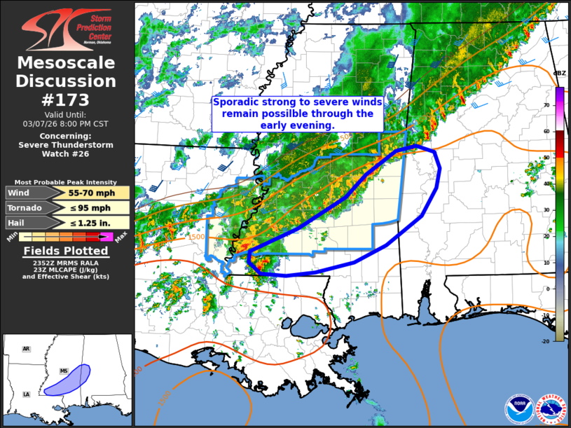
MD 0173 CONCERNING SEVERE THUNDERSTORM WATCH 26… FOR SOUTHERN MISSISSIPPI INTO FAR WESTERN ALABAMA
Mesoscale Discussion 0173
NWS Storm Prediction Center Norman OK
0555 PM CST Sat Mar 07 2026

Areas affected...Southern Mississippi into far western Alabama

Concerning...Severe Thunderstorm Watch 26...

Valid 072355Z - 080200Z

The severe weather threat for Severe Thunderstorm Watch 26
continues.

SUMMARY...Damaging wind gusts remain possible as poorly organized
storm clusters migrate south/southeast across southern Mississippi
into far western Alabama.

DISCUSSION...Recent surface observations and radar imagery from KDGX
show a composite cold front/outflow boundary slowly pushing
southeast after a recent amalgamation of frontal and pre-frontal
convection. The recent storm interactions have yielded periodic
strong gusts per velocity imagery, but has also resulted in a recent
weakening trend of lingering convection. However, with the
southeastward surge of the front/outflow, new convection developing
on the boundary will mature in a environment characterized by 1500
J/kg. This may support a gradual uptick in thunderstorm intensity,
and given surface temperatures remaining in the low 80s and upper
70s (yielding low-level lapse rates on the order of 7-7.5 C/km),
sporadic strong to severe downburst winds appear possible over the
next couple of hours. With time, the onset of nocturnal
cooling/stabilization and weak wind shear with southeastward extent
should result in a gradual weakening of convection, but a localized
severe wind threat will likely persist for the next hour or so.

..Moore.. 03/07/2026

...Please see www.spc.noaa.gov for graphic product...

ATTN...WFO...BMX...MOB...JAN...LIX...

LAT...LON   31389119 31749032 32248944 32608906 32978849 33058811
            32968778 32698767 32388774 31948803 31498868 31228927
            31058999 30999052 31029100 31209122 31389119

MOST PROBABLE PEAK TORNADO INTENSITY...UP TO 95 MPH
MOST PROBABLE PEAK WIND GUST...55-70 MPH
MOST PROBABLE PEAK HAIL SIZE...UP TO 1.25 IN
Source link