| Mesoscale Discussion 171 | |
| < Previous MD | |

|
|
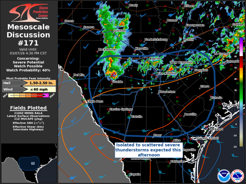
   Mesoscale Discussion 0171
   NWS Storm Prediction Center Norman OK
   0302 PM CST Sat Mar 07 2026

   Areas affected...South Central Texas

   Concerning...Severe potential...Watch possible

   Valid 072102Z - 072230Z

   Probability of Watch Issuance...40 percent

   SUMMARY...Severe thunderstorm coverage is expected to increase
   across portions of south-central Texas this afternoon into the early
   evening. Damaging winds and large hail are the primary concerns,
   particularly with an ongoing cell in far southwestern Texas.

   DISCUSSION...As a southward-moving, convectively-modified cold front
   moves across portions of central and southwestern Texas, severe
   storm activity is expected to increase in the short term --
   particularly with a supercell tracking eastward from Uvalde. MUCAPE
   of 2000-3000 J/kg and effective shear of 35-40 kts will support
   continued convective development and organization along the modified
   cold front/outflow boundary. The primary threat will be for damaging
   winds and large hail, with storms continuing to pose such a threat
   even after being undercut by the cold front/outflow boundary. A
   severe thunderstorm watch may be needed in the next hour or two.

   ..Halbert/Guyer.. 03/07/2026

   ...Please see www.spc.noaa.gov for graphic product...

   ATTN...WFO...HGX...CRP...EWX...

   LAT...LON   28120005 28620030 29110043 29600042 29820017 29919986
               29919920 29919855 30069765 30049736 29899704 29549685
               29089685 28679690 28309708 28039749 27899792 27899840
               27919938 28120005

   MOST PROBABLE PEAK WIND GUST...UP TO 60 MPH
   MOST PROBABLE PEAK HAIL SIZE...1.50-2.50 IN
|
|
|
Top/All Mesoscale Discussions/Forecast Products/Home |
|
Source link