| Mesoscale Discussion 168 | |
| < Previous MD Next MD > | |

|
|
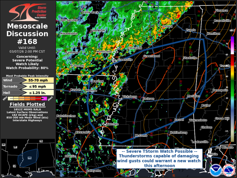
   Mesoscale Discussion 0168
   NWS Storm Prediction Center Norman OK
   1254 PM CST Sat Mar 07 2026

   Areas affected...Northeastern Louisiana into Mississippi and Far
   Western Alabama

   Concerning...Severe potential...Watch likely

   Valid 071854Z - 072000Z

   Probability of Watch Issuance...80 percent

   SUMMARY...Severe thunderstorms capable of damaging wind gusts are
   expected to increase in coverage across portions of northeastern
   Louisiana into much of central Mississippi and portions of western
   Alabama. A new severe thunderstorm watch could be issued this
   afternoon.

   DISCUSSION...A line of thunderstorms across northern Louisiana into
   northern Mississippi continues south-southeast across the discussion
   area, with additional thunderstorm development ahead of this line
   ongoing as daytime heating reaches convective temperatures. These
   thunderstorms will be capable of damaging wind gusts up to 70 MPH,
   with the greatest threat being with any localized bowing segments or
   downbursts supported by modest DCAPE and well-mixed boundary layers.
   A new severe thunderstorm watch is being considered for this
   afternoon.

   ..Halbert/Guyer.. 03/07/2026

   ...Please see www.spc.noaa.gov for graphic product...

   ATTN...WFO...BMX...MOB...MEG...JAN...LIX...SHV...

   LAT...LON   31089089 31249158 31669194 32249205 32899198 33249139
               33739015 34068848 34028809 33548802 33118802 32768805
               32398826 31948845 31808875 31478970 31089089

   MOST PROBABLE PEAK TORNADO INTENSITY...UP TO 95 MPH
   MOST PROBABLE PEAK WIND GUST...55-70 MPH
   MOST PROBABLE PEAK HAIL SIZE...UP TO 1.25 IN
|
|
|
Top/All Mesoscale Discussions/Forecast Products/Home |
|
Source link