| Mesoscale Discussion 166 | |
| < Previous MD | |

|
|
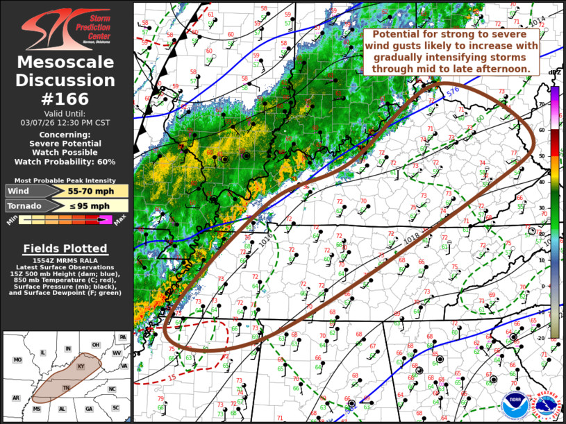
   Mesoscale Discussion 0166
   NWS Storm Prediction Center Norman OK
   0957 AM CST Sat Mar 07 2026

   Areas affected...parts of southern Ohio...much of Kentucky...western
   and middle Tennessee...and adjacent northern
   Mississippi/northwestern Alabama

   Concerning...Severe potential...Watch possible

   Valid 071557Z - 071830Z

   Probability of Watch Issuance...60 percent

   SUMMARY...Gradually intensifying and organizing thunderstorm
   activity may pose increasing potential to produce strong to severe
   wind gusts while spreading eastward through 1-3 PM CST (2-4 PM EST).
   One or more severe weather watches may be needed within the next few
   hours.

   DISCUSSION...A corridor of stronger 2 hourly surface pressure rises
   (on the order of 3-5 mb) has been developing northeastward across
   the Batesville and Walnut Ridge vicinity of northeastern Arkansas
   into areas near/east of Poplar Bluff MO, in the wake of stronger
   convection developing northeastward/eastward along a slower moving
   congomerate outflow boundary.  This appears to be accompanying a low
   amplitude perturbation and associated lower/mid-tropospheric jet
   streak forecast to overspread much of Kentucky and Tennessee through
   18-21Z.  The Rapid Refresh suggests this belt of flow may weaken
   some, but maintain west-south winds in the 850-700 mb layer at
   speeds of 30-50 kt.

   Coupled with boundary-layer destabilization associated ongoing
   insolation, and continuing low-level moisture advection (including
   surface dew points increasing through the lower/mid 60s F) ahead of
   the convection, the environment appears likely to support at least
   gradually intensifying and organizing thunderstorm activity.  As
   this proceeds through early and mid afternoon, potential for
   increasingly widespread strong to locally severe wind gusts seems
   likely to increase.

   ..Kerr/Guyer.. 03/07/2026

   ...Please see www.spc.noaa.gov for graphic product...

   ATTN...WFO...RLX...MRX...JKL...ILN...LMK...OHX...HUN...PAH...
   MEG...

   LAT...LON   37708632 39088432 38178232 37208338 34698803 34789016
               36968811 37708632

   MOST PROBABLE PEAK TORNADO INTENSITY...UP TO 95 MPH
   MOST PROBABLE PEAK WIND GUST...55-70 MPH
|
|
|
Top/All Mesoscale Discussions/Forecast Products/Home |
|
Source link