| Mesoscale Discussion 164 | |
| < Previous MD | |

|
|
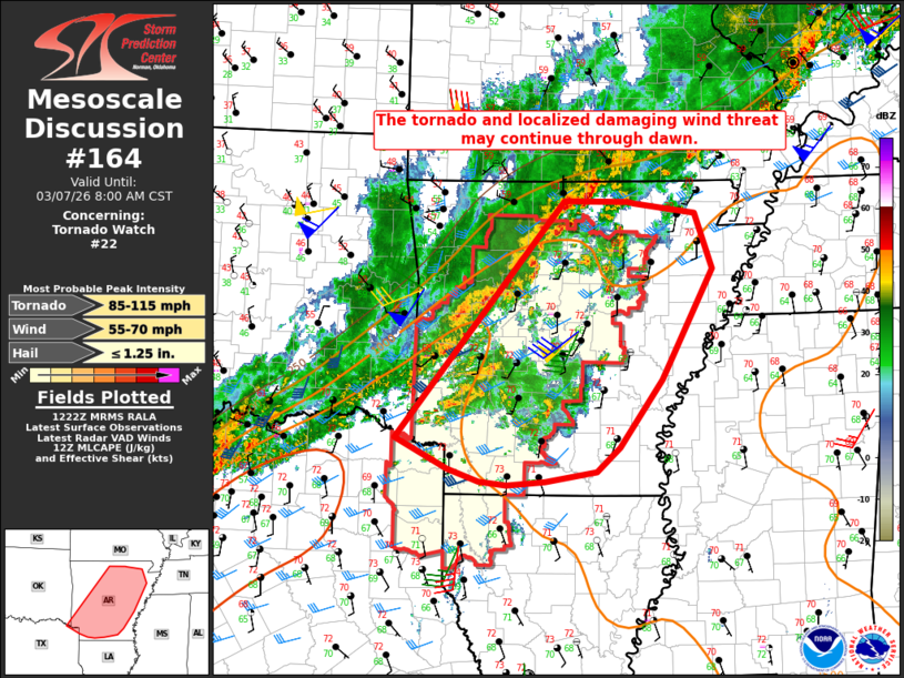
Mesoscale Discussion 0164 NWS Storm Prediction Center Norman OK 0624 AM CST Sat Mar 07 2026 Areas affected...Parts of western/central AR into extreme northeast TX Concerning...Tornado Watch 22... Valid 071224Z - 071400Z The severe weather threat for Tornado Watch 22 continues. SUMMARY...The tornado and localized damaging wind threat may continue through dawn. DISCUSSION...A long-lived supercell has recently produced an apparent tornado in southwest AR (Nevada County). While some weakening and veering of low-level flow has been noted in the KSHV and KLZK VWPs, low-level shear/SRH remains more than sufficient for tornado potential with any sustained supercell, given the presence of moderate buoyancy and a seasonably warm/moist boundary layer. Aside from the tornadic supercell, other storms across southwest AR have been relatively disorganized, though it remains possible that an additional tornadic supercell may evolve out of convection within the prefrontal warm-advection regime. Farther northwest, a cold front is surging southeastward across west-central/northwest AR. As this front impinges upon the favorable downstream environment and ongoing warm-sector convection, at least a brief uptick in damaging-wind and brief tornado potential will be possible across parts of central/northern AR, before the threat ends from northwest to southeast later this morning. Some severe threat is expected to persist beyond the 14Z expiration time of WW 22. Local watch extension and/or downstream watch issuance is possible, depending on short-term trends regarding convective intensity and organization as storms approach central/eastern AR. ..Dean/Gleason.. 03/07/2026 ...Please see www.spc.noaa.gov for graphic product... ATTN...WFO...MEG...JAN...LZK...SHV... LAT...LON 36289244 36279158 36249148 36139068 35519045 34289114 33549171 33269202 33159270 33129321 33159359 33309400 33649471 36289244 MOST PROBABLE PEAK TORNADO INTENSITY...85-115 MPH MOST PROBABLE PEAK WIND GUST...55-70 MPH MOST PROBABLE PEAK HAIL SIZE...UP TO 1.25 IN |
|
|
Top/All Mesoscale Discussions/Forecast Products/Home |
|
Source link