| Mesoscale Discussion 158 | |
| < Previous MD Next MD > | |

|
|
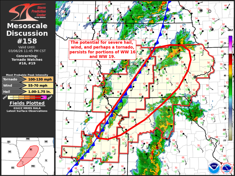
Mesoscale Discussion 0158 NWS Storm Prediction Center Norman OK 0943 PM CST Fri Mar 06 2026 Areas affected...Northeast Kansas into northern Missouri and eastern Iowa Concerning...Tornado Watch 16...19... Valid 070343Z - 070545Z The severe weather threat for Tornado Watch 16, 19 continues. SUMMARY...Some threat for severe hail, wind, and perhaps a tornado, persists across portions of WW 16 and WW 19 from northeast Kansas into northern Missouri and portions of eastern Iowa. DISCUSSION...Latest regional radar imagery depicts most of the ongoing convection across northeast KS and into western IA being undercut by a strong cold front. Despite this, GOES IR imagery has shown a few stronger updrafts developing over the past 30 minutes along the post-frontal convective line, and cooling cloud-top temperatures are noted with pre-frontal convection across central/eastern IA as well. While much of this activity is elevated in nature, it remains in a conditionally favorable environment for severe convection with MUCAPE remaining near 1500 J/kg and effective bulk shear near 50 knots. This will continue to support some potential for organized deep convection capable of producing sporadic large hail and perhaps damaging winds. Latest guidance hints that ongoing warm advection ahead of the front may support additional thunderstorms in the coming hours - particularly from northern MO into southern IA. If such convection emerges, the favorably sheared environment may support some tornado threat, though this potential is uncertain given no signs of imminent surface-based development within the pre-frontal regime. ..Moore.. 03/07/2026 ...Please see www.spc.noaa.gov for graphic product... ATTN...WFO...DVN...DMX...EAX...OAX...TOP... LAT...LON 39429616 39929557 42549320 42649240 42639178 42419142 42059134 41649150 40979201 40389280 39719375 39109498 38939563 38949589 38969613 39169630 39429616 MOST PROBABLE PEAK TORNADO INTENSITY...100-130 MPH MOST PROBABLE PEAK WIND GUST...55-70 MPH MOST PROBABLE PEAK HAIL SIZE...1.00-1.75 IN |
|
|
Top/All Mesoscale Discussions/Forecast Products/Home |
|
Source link