| Mesoscale Discussion 155 | |
| < Previous MD | |

|
|
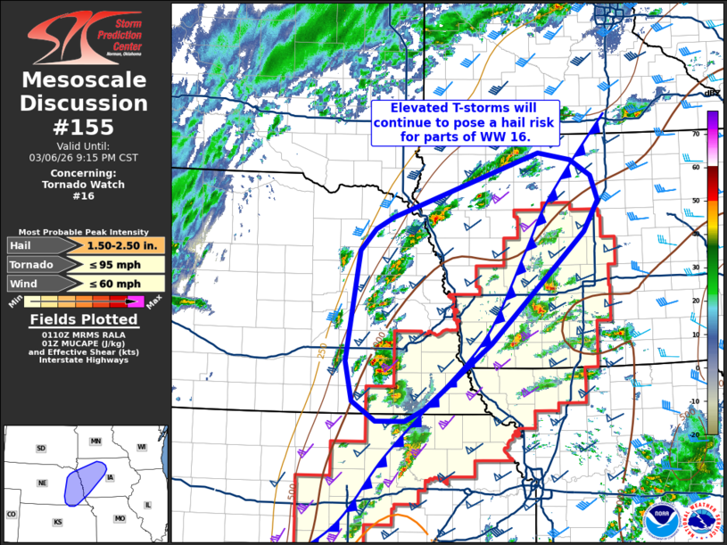
Mesoscale Discussion 0155 NWS Storm Prediction Center Norman OK 0712 PM CST Fri Mar 06 2026 Areas affected...Eastern Nebraska into western Iowa Concerning...Tornado Watch 16... Valid 070112Z - 070315Z The severe weather threat for Tornado Watch 16 continues. SUMMARY...Elevated thunderstorms to the north of a cold front will continue to pose a large to very large hail threat for the next several hours. DISCUSSION...Elevated thunderstorms developing to the north of a surging cold front have produced hail stones ranging from 1 to 2 inches over the past hour. Although radar presentation of these cells has been somewhat meager, the 00z OAX sounding sampled 1250 J/kg MUCAPE above the frontal surface and an elongated hodograph characterized by effective bulk shear on the order of 50 knots. This environment is very favorable for splitting supercells capable of producing large/very large hail. Per latest RAP mesoanalysis estimates, this environment extends eastward into western IA, and additional cells are noted developing within the post-frontal regime across eastern NE/western IA. These trends suggest that the threat for large hail is likely increasing, though it remains somewhat unclear how long storm mode will remain discrete/semi-discrete downstream. Regardless, additionally watch issuance may be needed in the coming hours to address this threat if the developing cells remain highly efficient at hail production. ..Moore.. 03/07/2026 ...Please see www.spc.noaa.gov for graphic product... ATTN...WFO...DMX...EAX...FSD...OAX...TOP...GID... LAT...LON 39919673 39909722 40159761 40669771 42049748 42329722 42469693 43269450 43189395 42979361 42679350 42289374 41969408 40889529 40059641 39919673 MOST PROBABLE PEAK TORNADO INTENSITY...UP TO 95 MPH MOST PROBABLE PEAK WIND GUST...UP TO 60 MPH MOST PROBABLE PEAK HAIL SIZE...1.50-2.50 IN |
|
|
Top/All Mesoscale Discussions/Forecast Products/Home |
|
Source link