| Mesoscale Discussion 153 | |
| < Previous MD | |

|
|
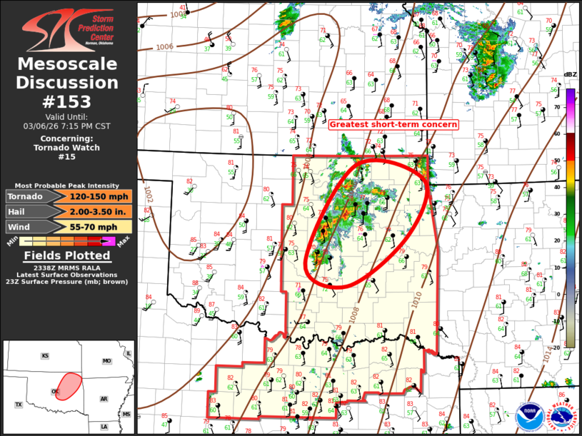
Mesoscale Discussion 0153 NWS Storm Prediction Center Norman OK 0541 PM CST Fri Mar 06 2026 Areas affected...Portions of central and northeast Oklahoma Concerning...Tornado Watch 15... Valid 062341Z - 070115Z The severe weather threat for Tornado Watch 15 continues. SUMMARY...Scattered supercells will spread northeast across east-central and northeast Oklahoma this evening. DISCUSSION...Roughly half a dozen supercells have evolved within a larger complex of convection across east-central into northeast Oklahoma. This activity has evolved along the eastern most plume of steeper low-level lapse rates where boundary layer remains moist and MLCAPE values are holding around 2000 J/kg. LLJ is currently focused across eastern OK, and some strengthening is expected during the evening hours. Current thinking is, for the next few hours, the greatest concentration of convection/supercells will be along a corridor from near Ada into the northeast corner of ww015. ..Darrow.. 03/06/2026 ...Please see www.spc.noaa.gov for graphic product... ATTN...WFO...TSA...OUN... LAT...LON 35179718 36849614 36589468 35609506 34789631 35179718 MOST PROBABLE PEAK TORNADO INTENSITY...120-150 MPH MOST PROBABLE PEAK WIND GUST...55-70 MPH MOST PROBABLE PEAK HAIL SIZE...2.00-3.50 IN |
|
|
Top/All Mesoscale Discussions/Forecast Products/Home |
|
Source link