| Mesoscale Discussion 152 | |
| < Previous MD | |

|
|
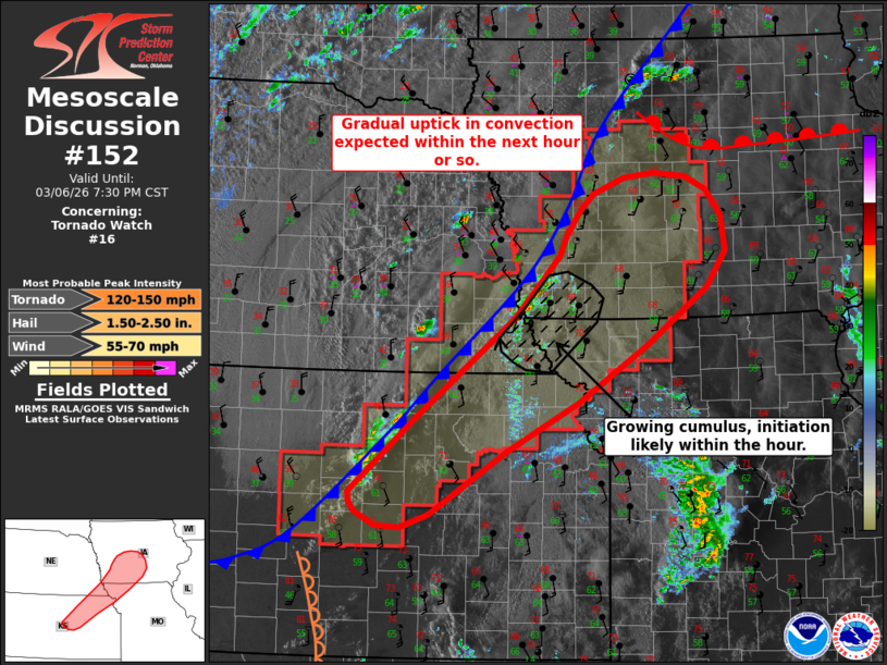
Mesoscale Discussion 0152 NWS Storm Prediction Center Norman OK 0523 PM CST Fri Mar 06 2026 Areas affected...Northeast Kansas into central Iowa Concerning...Tornado Watch 16... Valid 062323Z - 070130Z The severe weather threat for Tornado Watch 16 continues. SUMMARY...Convective coverage is expected to gradually increase over the next couple of hours with early stages of additional thunderstorm development noted along a surging cold front. Consequently, the overall severe threat will likely increase heading into the early evening hours. DISCUSSION...Thunderstorm development along the front has so far been lackluster - likely owing to a combination of undercutting from the cold front and residual capping across the warm sector. However, latest GOES one-minute imagery shows a cluster of deepening cumulus across far southeast NE/southwest IA just ahead of the front, and cooling cloud-top temperatures with an uptick in lighting counts is noted across northeast KS. These signs suggest that the severe threat remains in place across WW 16 and an uptick in strong/severe thunderstorm coverage is possible in the coming hours. Strong along-boundary flow coupled with the surging nature of the front casts considerable uncertainty on whether storms will remain rooted along the boundary or will be undercut quickly to the cool side of the boundary. Regardless, severe hail may be possible within initially semi-discrete storms before a transition to primarily a severe wind and tornado threat occurs - especially if storms can remain rooted on the warm side of the boundary. This appears most probable across southwest to central IA downstream of the ongoing cumulus development and where recent CAM output has suggested pre-frontal cells will be possible within a buoyant and strongly sheared environment. ..Moore.. 03/06/2026 ...Please see www.spc.noaa.gov for graphic product... ATTN...WFO...DMX...EAX...OAX...TOP...ICT... LAT...LON 38509704 38379742 38389777 38539804 38639812 38739813 39509724 40579589 40969552 41249527 41459517 41709498 41889480 42059438 42099397 42059354 41929324 41649305 41289299 40909325 40309407 39689501 39169601 38509704 MOST PROBABLE PEAK TORNADO INTENSITY...120-150 MPH MOST PROBABLE PEAK WIND GUST...55-70 MPH MOST PROBABLE PEAK HAIL SIZE...1.50-2.50 IN |
|
|
Top/All Mesoscale Discussions/Forecast Products/Home |
|
Source link