| Mesoscale Discussion 141 | |
| < Previous MD | |

|
|
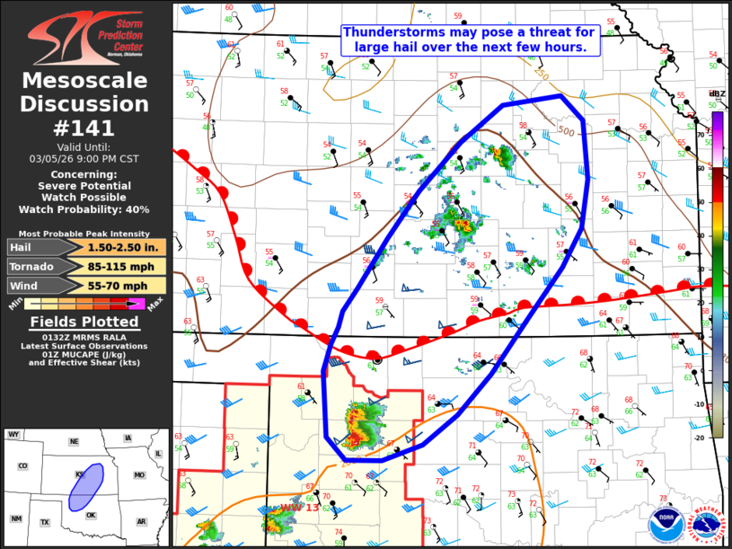
Mesoscale Discussion 0141 NWS Storm Prediction Center Norman OK 0735 PM CST Thu Mar 05 2026 Areas affected...portions of northern Oklahoma into central Kansas Concerning...Severe potential...Watch possible Valid 060135Z - 060300Z Probability of Watch Issuance...40 percent SUMMARY...Thunderstorms may pose a risk for large hail, and perhaps an isolated tornado, over the next 1-2 hours. Local watch extensions and potentially a new Severe Thunderstorm Watch may be needed. DISCUSSION...Isolated thunderstorms have developed across portions of northern Oklahoma into central Kansas over the past hour, including a stronger storm within the northern portions of WW0013. Some uncertainty remains regarding the persistence of these storms as they progress northeastward given rather weak synoptic-scale forcing. Should storms become better established along and north of a surface frontal boundary, however, they will pose a risk for large hail given MUCAPE of 1000-2000 J/kg and effective bulk shear of 30-40 kts amidst steep mid-level lapse rates of 7-7.5 C/km. As the surface warm front lifts farther north, increasing low-level moisture (dewpoints approaching 60 F along the KS/OK border) coupled with a strengthening low-level jet sampled by regional VWPs may support the potential for an isolated tornado with any surface-based storms along and south of the surface boundary. Trends will continue to be monitored, and local watch extensions or perhaps a new Severe Thunderstorm Watch may be needed. ..Chalmers/Moore/Hart.. 03/06/2026 ...Please see www.spc.noaa.gov for graphic product... ATTN...WFO...TOP...ICT...OUN...DDC... LAT...LON 37499892 37979855 38469816 38949762 39319708 39409634 39159605 38579600 38079610 37699635 37179680 36629724 36229766 35929809 35769859 35769905 35999929 36649934 36929925 37099916 37259910 37499892 MOST PROBABLE PEAK TORNADO INTENSITY...85-115 MPH MOST PROBABLE PEAK WIND GUST...55-70 MPH MOST PROBABLE PEAK HAIL SIZE...1.50-2.50 IN |
|
|
Top/All Mesoscale Discussions/Forecast Products/Home |
|
Source link