| Mesoscale Discussion 140 | |
| < Previous MD | |
|
|
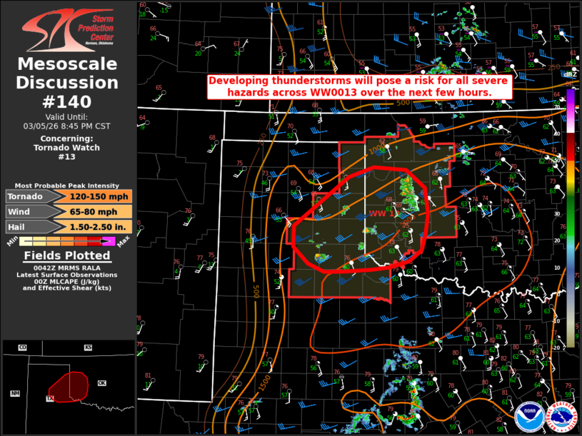
Mesoscale Discussion 0140 NWS Storm Prediction Center Norman OK 0645 PM CST Thu Mar 05 2026 Areas affected...portions of the eastern Texas Panhandle into western Oklahoma Concerning...Tornado Watch 13... Valid 060045Z - 060245Z The severe weather threat for Tornado Watch 13 continues. SUMMARY...Thunderstorms will pose a risk for all severe hazards over the next 1-2 hours as they progress east/northeastward across the eastern Texas Panhandle and into western Oklahoma. DISCUSSION...Developing thunderstorms have struggled to become better established across portions of the eastern Texas Panhandle over the past hour amidst residual capping and weak synoptic-scale forcing. While it remains unclear as to how many supercells will develop, the latest guidance and radar observations continue to suggest that at least a couple of supercells will become better established over the coming 1-2 hours as mid-level capping continues to erode. An unstable environment characterized by MLCAPE of 1500-2000 J/kg and effective bulk shear of 30-40 kts will then support a risk of all severe hazards. Steep mid-level lapse rates exceeding 7.5 C/km and an initial discrete storm mode will support the potential for large hail to 3" in diameter. With time, a strengthening low-level jet is expected to yielding enlarged low-level hodographs, which would bring an increased tornado threat into the early overnight hours. ..Chalmers/Moore.. 03/06/2026 ...Please see www.spc.noaa.gov for graphic product... ATTN...WFO...OUN...LUB...AMA... LAT...LON 35269867 34909874 34639881 34449909 34349948 34309986 34270039 34260084 34400117 34700149 35050148 35520086 35900034 36079981 36019912 35709873 35269867 MOST PROBABLE PEAK TORNADO INTENSITY...120-150 MPH MOST PROBABLE PEAK WIND GUST...65-80 MPH MOST PROBABLE PEAK HAIL SIZE...1.50-2.50 IN |
|
|
Top/All Mesoscale Discussions/Forecast Products/Home |
|
Source link