| Mesoscale Discussion 137 | |
| < Previous MD | |
|
|
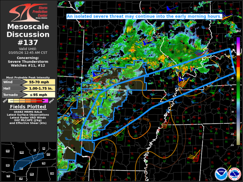
Mesoscale Discussion 0137 NWS Storm Prediction Center Norman OK 1051 PM CST Wed Mar 04 2026 Areas affected...Parts of the Ozarks into the Lower Ohio Valley Concerning...Severe Thunderstorm Watch 11...12... Valid 050451Z - 050645Z The severe weather threat for Severe Thunderstorm Watch 11, 12 continues. SUMMARY...An isolated severe threat may continue into the early morning hours. DISCUSSION...Widespread convection is ongoing late this evening from near the OK/AR border into parts of the Lower Ohio Valley, in advance of a mid/upper-level shortwave trough moving across the Lower Missouri Valley. A strengthening low-level jet (observed on recent VWPs from KLZK and KNQA) will sustain convection into the overnight hours from northern AR/southern MO into parts of southern IL/IN and western KY. Much of this convection will remain north of an outflow-reinforced cold front, where modest elevated buoyancy and sufficient effective shear will continue to support an isolated hail threat. Convection near/south of the front (such as the supercell in far southeast OK and the cluster of storms in far southern IL) may remain near-surface based into the early morning, and pose a threat of isolated hail, damaging gusts, and possibly a brief tornado (given the favorable low-level SRH). Some loosely organized upscale growth remains possible with time, though ongoing trends and most short-term guidance suggest that the severe threat will tend to remain isolated into the early morning. WW 11 and WW 12 are scheduled to expire at 05Z, and new watch issuance appears unlikely, unless an uptick in storm organization and intensity is observed. ..Dean/Hart.. 03/05/2026 ...Please see www.spc.noaa.gov for graphic product... ATTN...WFO...LMK...OHX...PAH...MEG...LSX...LZK...SGF...SHV... TSA... LAT...LON 36319365 36719280 37089145 37548954 37938803 38218656 37168632 35769080 35289156 34639272 34269382 34289459 34849447 36319365 MOST PROBABLE PEAK TORNADO INTENSITY...UP TO 95 MPH MOST PROBABLE PEAK WIND GUST...55-70 MPH MOST PROBABLE PEAK HAIL SIZE...1.00-1.75 IN |
|
|
Top/All Mesoscale Discussions/Forecast Products/Home |
|
Source link