| Mesoscale Discussion 126 | |
| < Previous MD | |

|
|
Mesoscale Discussion 0126
NWS Storm Prediction Center Norman OK
0529 AM CST Mon Mar 02 2026
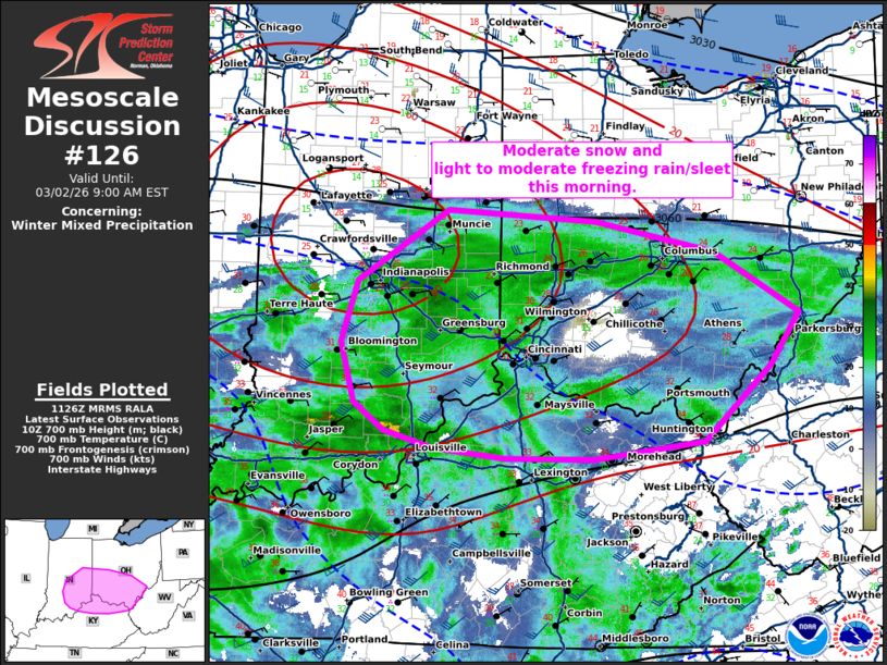
Areas affected...Eastern Indiana...central and southern Ohio...and
northern Kentucky.
Concerning...Winter mixed precipitation
Valid 021129Z - 021400Z
SUMMARY...Moderate snow and light to moderate freezing rain/sleet
will continue this morning.
DISCUSSION...Moderate isentropic ascent ahead of a weak mid-level
shortwave trough has resulted in a broad region of light to moderate
precipitation within the Ohio Valley. On the northern extent of this
precipitation shield, some frontogenetical banding (centered around
700mb) has resulted in moderate snow across portions of eastern
Indiana into central Ohio. South of this snow band, warmer
temperatures aloft have resulted in a combination of sleet and
freezing rain. The wet-bulb zero line is centered near I-64 this
morning and will likely delineate the area to the south with mostly
rain and the area to the north which could see some ice accretion
(up to 0.05 inches per hour) for a few hours this morning.
This combination of moderate snow across central Ohio and mixed
precipitation across southeast Indiana, southern Ohio, and northern
Kentucky will continue through mid morning, before temperatures warm
above freezing and it changes to all rain across most of the region
by late morning.
..Bentley.. 03/02/2026
...Please see www.spc.noaa.gov for graphic product...
ATTN...WFO...PBZ...RLX...JKL...ILN...LMK...IWX...IND...
LAT...LON 40388538 40288374 40018241 39478148 39038180 38368254
38228376 38228476 38318556 38478609 38708643 39228657
39768640 40388538
|
|
|
Top/All Mesoscale Discussions/Forecast Products/Home |
|
Source link