| Mesoscale Discussion 122 | |
| < Previous MD | |
|
|
Mesoscale Discussion 0122
NWS Storm Prediction Center Norman OK
0535 AM CST Sat Feb 28 2026
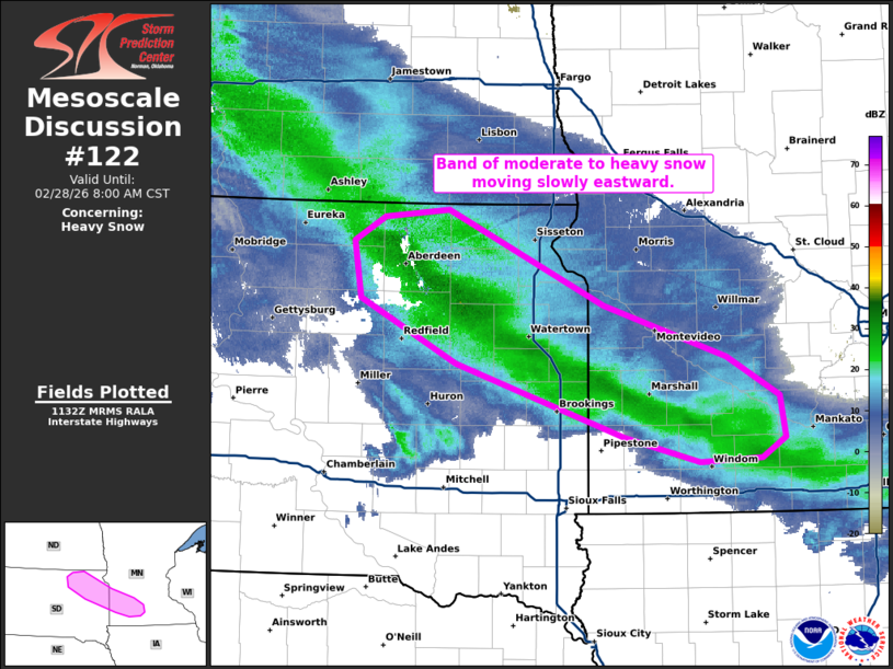
Areas affected...Northeast South Dakota into parts of southwest
Minnesota
Concerning...Heavy snow
Valid 281135Z - 281400Z
SUMMARY...A band of moderate to heavy snow is moving slowly eastward
across northeast South Dakota and into southwest Minnesota.
DISCUSSION...A narrow band of around 1 inch+ per hour snowfall rates
is moving slowly eastward across northeast South Dakota and into
southwest Minnesota. Observations are somewhat limited within this
narrow band, but where the heaviest snow has been observed, less
than 1/4 mile visibility was observed in Redfield, SD. This band is
associated with strong frontogenesis centered between 850 and 700mb.
This band will drift slowly eastward through the morning and will be
mostly across southern Minnesota by mid-day. Frontogenesis strength
should maintain through the afternoon. However, drier air across
Minnesota may lessen rates somewhat as this band shifts east.
..Bentley.. 02/28/2026
...Please see www.spc.noaa.gov for graphic product...
ATTN...WFO...MPX...FSD...ABR...
LAT...LON 44679791 45199896 45649904 45839870 45889800 45149628
44739493 44429434 44089429 43929455 43909523 44109605
44679791
|
|
|
Top/All Mesoscale Discussions/Forecast Products/Home |
|
Source link