| Mesoscale Discussion 119 | |
| < Previous MD | |

|
|
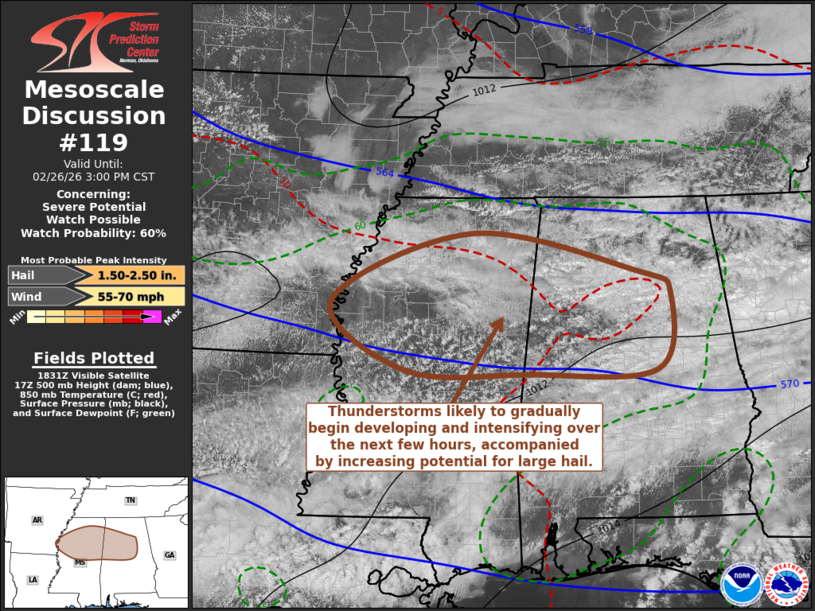
   Mesoscale Discussion 0119
   NWS Storm Prediction Center Norman OK
   1236 PM CST Thu Feb 26 2026

   Areas affected...parts of northern and central Mississippi and
   Alabama

   Concerning...Severe potential...Watch possible

   Valid 261836Z - 262100Z

   Probability of Watch Issuance...60 percent

   SUMMARY...Thunderstorms are likely to begin to initiate and
   intensify through 3-4 PM CST, accompanied by increasing risk for
   large hail which probably will persist into early evening while
   tending to propagate southeastward.

   DISCUSSION...Insolation within a moist boundary layer characterized
   by lower to mid 60s F dew points is contributing to destabilization,
   in the presence of modestly steep lower/mid-tropospheric lapse rates
   with cool mid-level temperatures.  CAPE is now increasing through
   the 500-1000 J/kg range, and slowly deepening convective development
   is evident along and south of the frontal zone advancing south of
   the southern Tennessee border vicinity.

   Rapid Refresh forecast soundings suggest that weak capping layers
   linger aloft, but it appears that these may gradually erode through
   20-22Z, aided by forcing for ascent downstream of low-amplitude
   mid/upper troughing digging across the southern Great Plains through
   lower Mississippi Valley vicinity.  As isolated to widely scattered
   thunderstorm development begins to initiate during the next couple
   of hours, deep-layer shear beneath strong cyclonic mid/upper flow
   may contribute to organizing supercell structures with potential to
   produce large hail.  Modest to weak low-level shear seems to limit
   the risk for tornadoes, and anything more than very localized
   downbursts would seem to await more substantive possible upscale
   growth later this afternoon or early evening.

   ..Kerr/Smith.. 02/26/2026

   ...Please see www.spc.noaa.gov for graphic product...

   ATTN...WFO...BMX...HUN...MEG...JAN...LZK...

   LAT...LON   34558913 34078665 33798617 32838637 32798828 32839010
               33689123 34558913

   MOST PROBABLE PEAK WIND GUST...55-70 MPH
   MOST PROBABLE PEAK HAIL SIZE...1.50-2.50 IN
|
|
|
Top/All Mesoscale Discussions/Forecast Products/Home |
|
Source link