| Mesoscale Discussion 118 | |
| < Previous MD | |

|
|
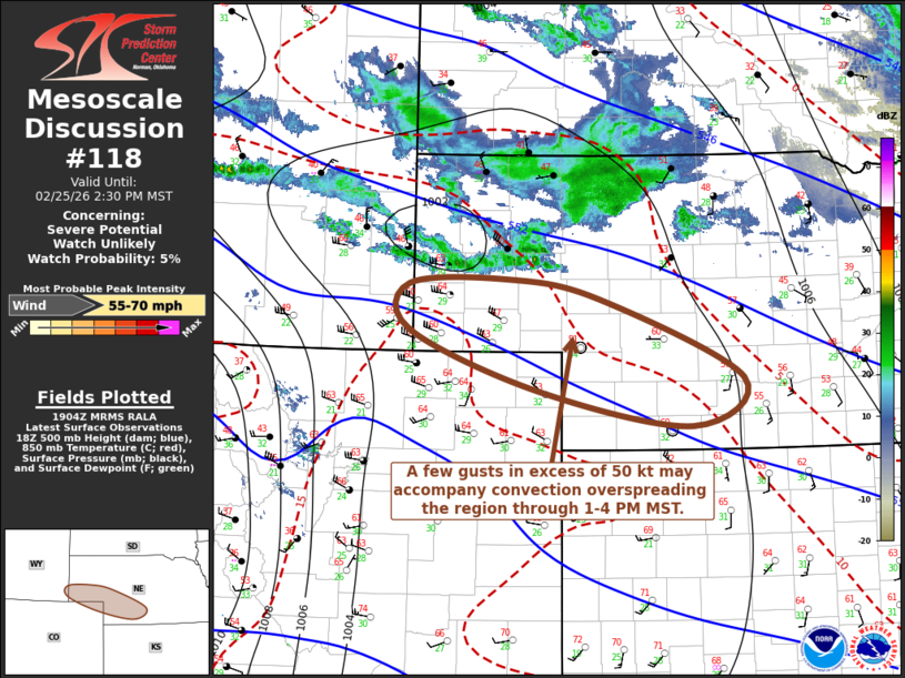
   Mesoscale Discussion 0118
   NWS Storm Prediction Center Norman OK
   0107 PM CST Wed Feb 25 2026

   Areas affected...parts of southwestern Nebraska and adjacent
   northeastern Colorado/southeastern Wyoming

   Concerning...Severe potential...Watch unlikely

   Valid 251907Z - 252130Z

   Probability of Watch Issuance...5 percent

   SUMMARY...A few strong surface gusts in excess of 50 kt may
   accompany otherwise weak thunderstorm activity overspreading the
   region through 1-4 PM MST.

   DISCUSSION...Near the southern periphery of a low-amplitude digging
   short wave perturbation, lower/mid-tropospheric lapse rates are in
   the process of becoming quite steep near the Cheyenne Ridge
   vicinity.  This is occurring in response to continuing insolation
   and deep boundary-layer mixing, beneath strong west-northwesterly
   flow which may include speeds increasing to 50+ kt as low as 700 mb
   during the next couple of hours.

   Despite boundary-layer moisture characterized by surface dew points
   around 30F, forecast soundings suggest the development of up to a
   few hundred J/kg of CAPE, which may maintain and perhaps support at
   least some further intensification of ongoing upstream convective
   development.   Some lightning is possible, but, more notably, this
   low-topped convection probably will enhance the downward transfer of
   the stronger momentum to the surface, before activity develops into
   a more stable environment deeper into the the Great Plains.

   ..Kerr/Smith.. 02/25/2026

   ...Please see www.spc.noaa.gov for graphic product...

   ATTN...WFO...GID...LBF...GLD...BOU...CYS...

   LAT...LON   41680410 41740279 41540154 40729960 40240029 40590235
               41210409 41680410

   MOST PROBABLE PEAK WIND GUST...55-70 MPH
|
|
|
Top/All Mesoscale Discussions/Forecast Products/Home |
|
Source link