| Mesoscale Discussion 111 | |
| < Previous MD | |
|
|
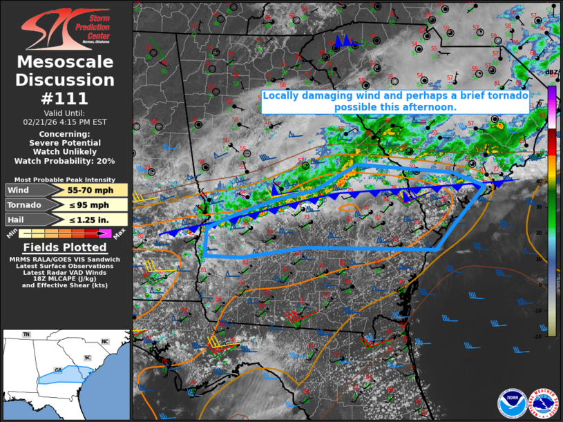
   Mesoscale Discussion 0111
   NWS Storm Prediction Center Norman OK
   1244 PM CST Sat Feb 21 2026

   Areas affected...Parts of central/southern GA into southern SC

   Concerning...Severe potential...Watch unlikely

   Valid 211844Z - 212115Z

   Probability of Watch Issuance...20 percent

   SUMMARY...Locally damaging wind and perhaps a brief tornado are
   possible this afternoon.

   DISCUSSION...A small bowing segment has recently become better
   organized across parts of east-central GA. Deep-layer flow/shear (as
   sampled by the KJGX and KCLX VWPs) remains favorable for organized
   convection, and MLCAPE has increased into the 1000-1500 J/kg range
   donwstream of this bowing segment, along/south of a cold front.
   However, while this bowing segment has taken on a somewhat more
   favorable north-south orientation, the front continues to sag
   southward immediately ahead of the most organized part of the line.
   This may temper severe-wind potential to some extent, though locally
   damaging wind remains possible, especially if the ongoing bowing
   segment can propagate along (rather than just north of) the front. A
   brief tornado also cannot be ruled out if any part of the line can
   persistently remain organized and surface-based, though generally
   front-parallel flow may continue to favor a general undercutting
   trend with time.

   ..Dean/Hart.. 02/21/2026

   ...Please see www.spc.noaa.gov for graphic product...

   ATTN...WFO...CHS...CAE...JAX...FFC...TAE...

   LAT...LON   31788093 31828320 31668432 31678496 32108494 32308446
               32528376 32688303 33068232 32938063 32728006 32158061
               31788093

   MOST PROBABLE PEAK TORNADO INTENSITY...UP TO 95 MPH
   MOST PROBABLE PEAK WIND GUST...55-70 MPH
   MOST PROBABLE PEAK HAIL SIZE...UP TO 1.25 IN
|
|
|
Top/All Mesoscale Discussions/Forecast Products/Home |
|
Source link