| Mesoscale Discussion 97 | |
| < Previous MD | |
|
|
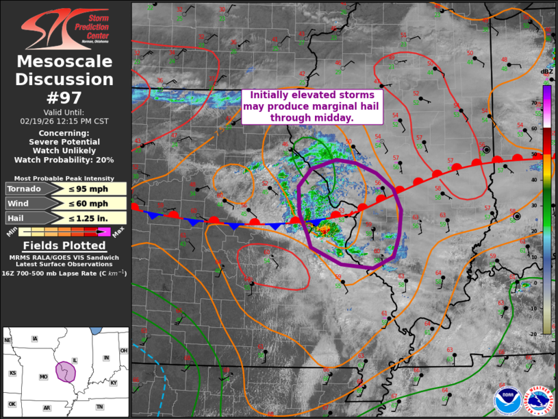
   Mesoscale Discussion 0097
   NWS Storm Prediction Center Norman OK
   1044 AM CST Thu Feb 19 2026

   Areas affected...east-central MO into west-central IL vicinity

   Concerning...Severe potential...Watch unlikely

   Valid 191644Z - 191815Z

   Probability of Watch Issuance...20 percent

   SUMMARY...Isolated storms may gradually increase in intensity over
   the next couple hours. Some small to marginally severe hail could
   accompany stronger cells in the short-term.

   DISCUSSION...Isolated elevated convection is persisting late this
   morning as storms approach the Mississippi River near the St. Louis
   Metro vicinity. These storms are occurring within warm advection in
   the vicinity of a warm front ahead of a shortwave impulse across
   southwest MO. Morning regional RAOBs show steep midlevel lapse
   rates, aided by cold temperatures aloft. While the boundary layer
   continues to moisten with time and eastward extent, instability will
   gradually increase. These storms will move into the improving
   thermodynamic environment downstream across IL. Given favorable
   vertical shear supporting organized convection, some gradual
   increase in intensity/organization is possible as convection spreads
   into west-central IL through midday, and isolated small to
   marginally severe hail is possible. The overall magnitude of the
   risk should remain limited over the MCD area, and a watch is not
   anticipated for this initial convection. Subsequent MCDs will
   address the expected downstream severe risk across southern/central
   IL/IN later this afternoon.

   ..Leitman/Mosier.. 02/19/2026

   ...Please see www.spc.noaa.gov for graphic product...

   ATTN...WFO...PAH...ILX...LSX...

   LAT...LON   38779124 39189127 39439103 39589055 39529018 39388979
               39158946 38828932 38468935 38138946 37968986 38039046
               38289102 38489110 38779124

   MOST PROBABLE PEAK TORNADO INTENSITY...UP TO 95 MPH
   MOST PROBABLE PEAK WIND GUST...UP TO 60 MPH
   MOST PROBABLE PEAK HAIL SIZE...UP TO 1.25 IN
|
|
|
Top/All Mesoscale Discussions/Forecast Products/Home |
|
Source link