| Mesoscale Discussion 2244 | |
| < Previous MD Next MD > | |
|
|
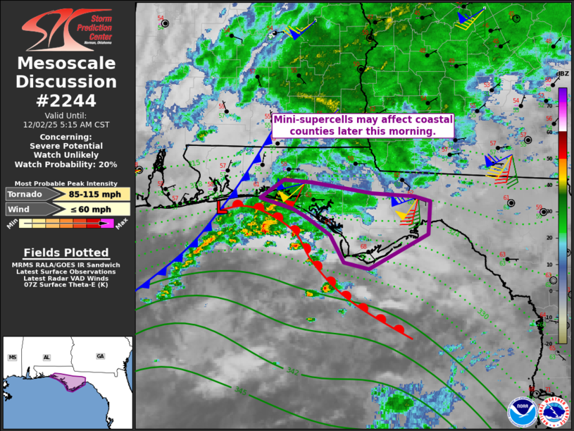
   Mesoscale Discussion 2244
   NWS Storm Prediction Center Norman OK
   0114 AM CST Tue Dec 02 2025

   Areas affected...the coastal Florida Panhandle

   Concerning...Severe potential...Watch unlikely

   Valid 020714Z - 021115Z

   Probability of Watch Issuance...20 percent

   SUMMARY...Mini-supercells may eventually move ashore, affecting
   primarily coastal counties of the Florida Panhandle. A brief tornado
   cannot be ruled out later tonight.

   DISCUSSION...Radar shows multiple small supercells over the
   northeastern Gulf of America, ahead of a cold front and along a warm
   front. The warm front is currently offshore as can be seen with
   backed surface winds over land and temperatures in the 60s F.

   Instability is currently weak, with minimal lightning detected even
   with the offshore activity. Conditionally, weak tornadoes may still
   occur assuming the warm front moves ashore.

   Recent hourly pressure falls over 1 mb indicate good column warming
   and likely erosion of the cooler air mass. Over the next few hours,
   surface winds will gradually veer, with temperatures likely jumping
   along the coast. Low-level shear will remain quite strong, again
   with instability being the limiting factor. However, any supercells
   that move onshore coincident with the warm front may result in
   localized brief tornado risk over a limited amount of inland area.

   ..Jewell/Mosier.. 12/02/2025

   ...Please see www.spc.noaa.gov for graphic product...

   ATTN...WFO...TAE...MOB...

   LAT...LON   30388653 30608620 30568581 30438497 30408437 30348416
               29948418 29528501 29598536 29938555 30158590 30248608
               30388653

   MOST PROBABLE PEAK TORNADO INTENSITY...85-115 MPH
   MOST PROBABLE PEAK WIND GUST...UP TO 60 MPH
|
|
|
Top/All Mesoscale Discussions/Forecast Products/Home |
|
Source link