|
|
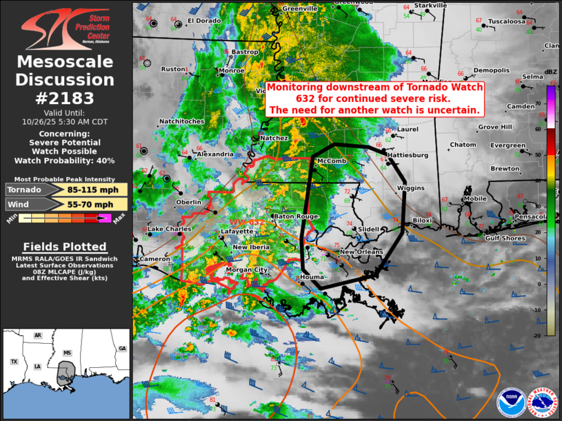
| Mesoscale Discussion 2183 | |

|
|
   Mesoscale Discussion 2183
   NWS Storm Prediction Center Norman OK
   0332 AM CDT Sun Oct 26 2025

   Areas affected...Parts of southeastern Louisiana and southern
   Mississippi

   Concerning...Severe potential...Watch possible

   Valid 260832Z - 261030Z

   Probability of Watch Issuance...40 percent

   SUMMARY...Monitoring parts of southeastern Louisiana and southern
   Mississippi for continued severe risk downstream of Tornado Watch
   632. The need for another watch is uncertain, though convective
   trends are being monitored.

   DISCUSSION...Storms have been struggling to organize/intensify as
   they track eastward across southern LA and southern MS in Tornado
   Watch 632. This is largely due to limited large-scale forcing for
   ascent and the lack of a low-level mass response amid poor lapse
   rates across the surface-based warm sector. Nevertheless, a
   conditionally favorable environment remains in place for rotating
   storms -- characterized by enlarged/clockwise-curved low-level
   hodographs (per HDC VWP) and lower 70s boundary-layer dewpoints.
   This environment will continue shifting eastward across southeastern
   LA and southern MS into the early morning hours. As a result, a
   continued conditional risk of a tornado or locally damaging gusts is
   being monitored. It is unclear if another watch will be needed,
   though convective trends are being monitored.

   ..Weinman/Smith.. 10/26/2025

   ...Please see www.spc.noaa.gov for graphic product...

   ATTN...WFO...MOB...JAN...LIX...

   LAT...LON   30209067 31369049 31559014 31508958 31398926 31018897
               30298903 29688947 29509036 29769064 30209067

   MOST PROBABLE PEAK TORNADO INTENSITY...85-115 MPH
   MOST PROBABLE PEAK WIND GUST...55-70 MPH
|
|
|
Top/All Mesoscale Discussions/Forecast Products/Home |
|
Source link