|
|
| Mesoscale Discussion 2177 | |
|
|
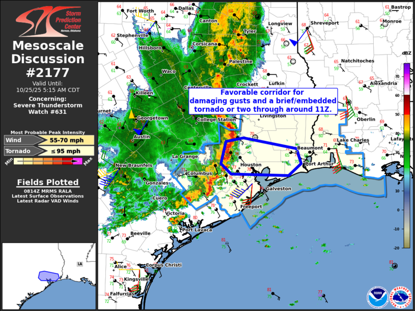
Mesoscale Discussion 2177 NWS Storm Prediction Center Norman OK 0316 AM CDT Sat Oct 25 2025 Areas affected...Parts of southeast Texas Concerning...Severe Thunderstorm Watch 631... Valid 250816Z - 251015Z The severe weather threat for Severe Thunderstorm Watch 631 continues. SUMMARY...Damaging wind gusts and a brief/embedded tornado or two remain possible in Severe Thunderstorm Watch 631 -- especially in a west-east corridor extending from parts of Harris County to Jefferson County through around 11Z. DISCUSSION...The latest radar data from KHGX and especially TIAH show several embedded/transient mesovortex structures within the convective line moving across southeast TX. As the line continues eastward, the combination of lower 70s dewpoints and enhanced low-level hodograph curvature (around 200 m2/s2 0-1km SRH per VWP data) will continue to support these transient/enhanced embedded circulations -- posing a risk of damaging gusts and possibly a brief tornado or two. The most favorable corridor appears to extend from parts of Harris County eastward to Jefferson County through around 11Z. ..Weinman.. 10/25/2025 ...Please see www.spc.noaa.gov for graphic product... ATTN...WFO...LCH...HGX... LAT...LON 29629427 29659553 29859576 30289566 30349526 30139408 29859398 29629427 MOST PROBABLE PEAK TORNADO INTENSITY...UP TO 95 MPH MOST PROBABLE PEAK WIND GUST...55-70 MPH |
|
|
Top/All Mesoscale Discussions/Forecast Products/Home |
|
Source link