|
|
| Mesoscale Discussion 2215 | |
| < Previous MD | |

|
|
   Mesoscale Discussion 2215
   NWS Storm Prediction Center Norman OK
   0706 AM CST Thu Nov 07 2024

   Areas affected...Northeast NM...Extreme Northwest TX Panhandle...Far
   Western OK Panhandle...Southeast CO

   Concerning...Heavy snow

   Valid 071306Z - 071700Z

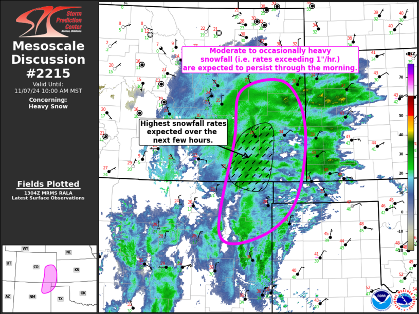
   SUMMARY...Moderate to occasionally heavy snowfall (i.e. rates
   exceeding 1"/hr.) are expected to persist across northeastern NM and
   eastern CO, and into adjacent portions of western KS and the western
   TX/OK Panhandle through the morning.

   DISCUSSION...Recent satellite imagery shows a notable baroclinic
   leaf across northeast NM and eastern CO, downstream of a deep upper
   low centered over AZ. This synoptic pattern is favoring strong
   mid-level warm-air advection across the warm sector of this cyclone,
   contributing to a broad area of precipitation across much of
   central/eastern NM and eastern CO, and into adjacent portions of
   western KS and the western TX/OK Panhandles. Thermodynamic profiles
   from east-central NM northward are cold enough for snow, and recent
   observations suggest moderate to occasionally heavy snow is ongoing
   across the region. The upper low is expected to drift slowly
   eastward throughout the day. With the slow motion of will keep much
   of this region in a favorable location for continued moderate to
   heavy snow, with snowfall rates occasionally topping 1" per hour
   across the lower elevations. The mid-level warm-air advection is
   currently maximized across northeast NM, suggesting the heaviest
   snowfall is most likely across southeast CO for the next few hours.

   ..Mosier.. 11/07/2024

   ...Please see www.spc.noaa.gov for graphic product...

   ATTN...WFO...GLD...AMA...PUB...BOU...ABQ...

   LAT...LON   37950413 39090394 39290264 38250206 36540236 35730337
               35760453 37950413
|
|
|
Top/All Mesoscale Discussions/Forecast Products/Home |
|


