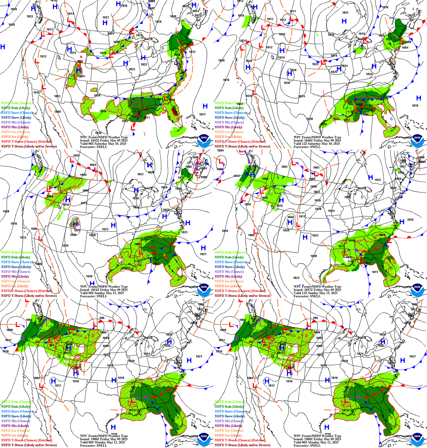
The forecasts depicted below combine WPC forecasts of fronts, isobars and high/low pressure centers with the NDFD depiction of expected weather type for days .5 to 2.5 ahead. Each frame represents 6 hours. A short range forecast discussion for the CONUS is available below the short term loop.
Short Term Forecast Frontal Systems and Isobars Loop

Short Range Forecast Discussion
FXUS01 KWBC 251905
PMDSPD

Short Range Forecast Discussion
NWS Weather Prediction Center College Park MD
304 PM EDT Wed Mar 25 2026

Valid 00Z Thu Mar 26 2026 - 00Z Sat Mar 28 2026

...Record-breaking heat continues to expand from the Southwest to
the Plains, Midwest, and Southeast...

...Wintry precipitation expected across the northern tier today
through Thursday...

...Severe thunderstorms likely across the Mid-Mississippi and Ohio
Valleys on Thursday...

Another record-breaking heat wave is underway, as a strong
upper-level ridge remains situated over the Southwest. The ridge
will shift east over the next couple of days, continuing to spread
into the Plains today, Midwest on Thursday, and Southeast on
Friday. Peak heat intensity is expected today into Thursday as
temperatures reach 25-35 degrees above seasonable average. High
temperatures in the 90s are expected from the Central/Southern
Plains to the Mid-Mississippi Valley. Intense heat will begin to
subside on Friday as the upper-level ridge weakens, although high
temperatures near 90 degrees will remain possible in the
Southeast. Numerous temperature records are expected to be tied or
broken during this heat wave.

A reprieve from the heat will arrive gradually from the north as a
strong cold front pushes across the country tonight through
Friday. Initially, an upper-level trough with an associated
Pacific frontal system will move in, which will round the top of
the ridge positioned over the Southwest and dig into the
north-central and northeastern U.S. on Thursday and Friday. A
stationary frontal boundary will continue to be in place across
the northern tier, and the progressive upper-level wave will drive
the front south across the central and eastern U.S. as a strong
cold front. Much colder air will arrive in the wake of the front,
with well below average temperatures expected for much of the
central and eastern U.S. Friday into Saturday. This frontal
boundary will be accompanied by wintry precipitation chances
across the northern tier today through early Thursday, with the
potential for several inches of snow in the Cascades and northern
Rockies.

Precipitation chances will also expand southward on Thursday, with
showers and thunderstorms expected from the central Plains to the
Mid-Atlantic. Scattered severe thunderstorms are expected across
the Mid-Mississippi and Ohio Valleys on Thursday afternoon and
evening. Severe storms are expected to bring a threat of very
large hail (2+ inches in diameter), severe wind gusts (some 70+
mph) and a few strong tornadoes. Precipitation chances will linger
in the Mid-Atlantic on Friday, with the front remaining mostly dry
as it moves across the South and Southeast. In addition to
precipitation chances, the frontal boundary will be accompanied by
strong winds, which will create Elevated to Critical fire weather
conditions across the northern/central Rockies and High Plains
today and central/southern Rockies and Plains Thursday.


Blanco-Alcala/Dolan


Graphics available at
https://www.wpc.ncep.noaa.gov/basicwx/basicwx_ndfd.php


$$
Depicted Weather Types
- NDFD Rain (Chance) – There is chance of measurable rain (≥0.01″) at the valid time.
- NDFD Rain (Likely) – Measurable rain (≥0.01″) is likely at the valid time.
- NDFD Snow (Chance) – There is chance of measurable snowfall (≥0.01″ liquid equivalent) at the valid time.
- NDFD Snow (Likely) – Measurable snow (≥0.01″ liquid equivalent) is likely at the valid time.
- NDFD Mix (Chance) – There is a chance of measurable mixed precipitation (≥0.01″ liquid equivalent) at the valid time. “Mixed” can refer to precipitation where a combination of rain and snow, rain and sleet, or snow and sleet are forecast.
- NDFD Mix (Likely) – Measurable mixed precipitation (≥0.01″ liquid equivalent) is likely at the valid time. “Mixed” can refer to precipitation where a combination of rain and snow, rain and sleet, or snow and sleet are forecast.
- NDFD Ice (Chance) – There is a chance of measurable sleet and/or freezing rain (≥0.01″ liquid equivalent) at the valid time.
- NDFD Ice (Likely) – Measurable sleet and/or freezing rain (≥0.01″ liquid equivalent) is likely at the valid time.
- NDFD T-Storm (Chance) – There is a chance of thunderstorms at the valid time. Areas are displayed with diagonal hatching enclosed in a dark red border.
- NDFD T-Storm (Likely and/or Severe) – Thunderstorms are likely and/or the potential exists for some storms to reach severe levels at the valid time.

