Yet another urban center has been seemingly laser-targeted with extraordinary cloudbursts in this strange U.S. summer of drought and flood. A series of “training” storms – well predicted by forecast models two days in advance – dropped torrential rain across the Dallas-Fort Worth metroplex from Sunday evening into midday Monday, August 20-21. At least one death was reported as of early Tuesday.
As discussed in a Saturday post at this site, the ingredients included a weak east-to-west frontal zone that straddled the DFW area, upper-level impulses traversing the front from west to east, and huge volumes of moisture drawn into northern Texas from the remnants of Potential Tropical Cyclone 4.
At Dallas-Fort Worth International Airport, the metro area’s main climate observing site, the total of 9.19 inches from 3 p.m. CDT Sunday to 3 p.m. Monday was the second heaviest on record for any 24-hour span, topped only by 9.57″ on September 4-5, 1932.
By itself, Monday was the metro area’s wettest day ever recorded in August, with 5.66″ swamping the 4.28″ observed on August 28, 1946. Official recordkeeping for the DFW area began in 1898.
Two other local airports notched similar totals from Sunday to Monday, according to Matt Moreland (National Weather Service/Southern Region Headquarters):
Fort Worth Meacham Field: 9.56“
Dallas Love Field: 9.14“
Even heavier totals were observed just east and south of downtown Dallas, on par with amounts one might expect in such a short period only about once every 1,000 years. The highest reported as of Monday night was 15.16″ at a gauge within the Dallas Area Flood Alert System located at White Rock Creek and Scyene Road. At least two CoCoRaHS stations, which typically report once each morning, recorded more than a foot of rain for the entire event, including 12.42″ near Mesquite and 12.31″ just northeast of downtown Dallas.


The period between about 1 and 2 AM Monday was the wettest hour in 69 years of hourly data at DFW Airport, as 3.01″ of rain fell. It was more rain than DFW had in any entire month this year, from January through July, as noted by Maxar/WeatherDesk.
A rain gauge on Ash Creek in Dallas, just south of Love Field, picked up an even higher one-hour total – 3.50″ — early Monday morning.
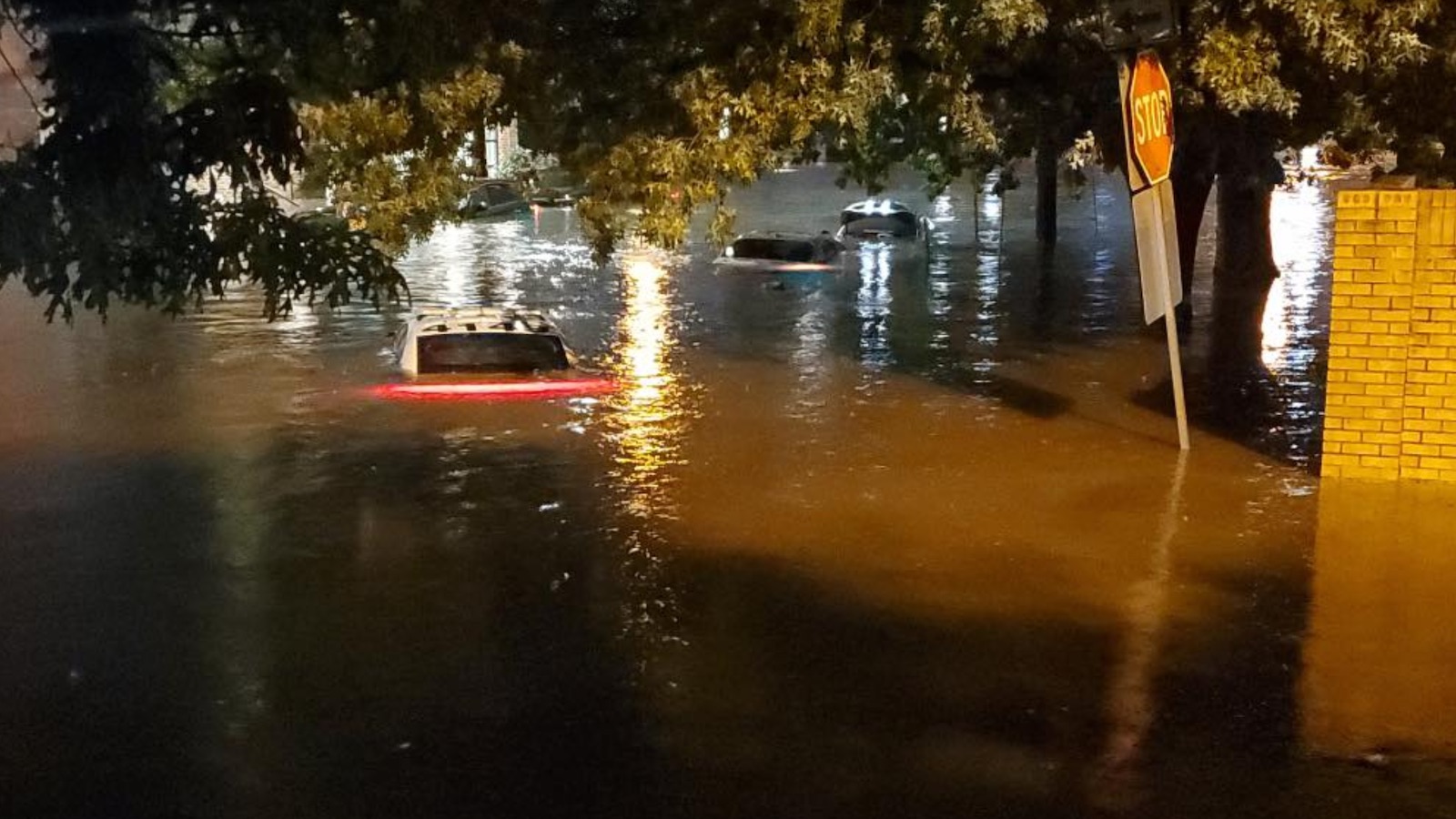
Major flash flooding was reported throughout the DFW area on Monday morning, with countless cars disabled and nearly 200 water rescues in Dallas alone. However, the waters receded quickly in most areas as the rains shifted south and east. The Trinity River at downtown Dallas spiked to moderate flood levels by Monday night, but higher crests have been observed many other times, including as recently as 2018.
Through August 9, DFW Airport had had no measurable rain for 67 days — the second longest dry spell in 126 years of record keeping for the urban area. Although immediate runoff and flash flooding can be accentuated over drought-parched land, the most intense rains in this case appeared to be localized enough to limit any broader river flood threat across the thirsty landscape.
2022 a ‘summer of floods‘
The string of exceptional rains and inundations in the United States this summer has gained notice from the UK-based Guardian, which dubbed 2022 “America’s summer of floods.”
The recent event most akin to the DFW gully-washer was the record rainfall in St. Louis, Missouri, on July 26. The city smashed its rainfall records for any 24-hour period (9.07″, far outpacing the old record of 7.02″) and for spans of one, two, and three calendar days. Much like the DFW event, training storms shifted from west to east along a weak stationary front, with impulses of energy from an upper-level trough to the north and rich moisture flowing in from the south. As with DFW, the heaviest rains across an entire region happened to be focused in and near a major metro area. In both cases, these were urban flash floods that hit highways and motorists the hardest, without causing catastrophic structural flooding despite the magnitude of the quick-hitting rains. Two lives were lost in the St. Louis area.
Far more destruction occurred in eastern Kentucky, when torrential rains along the same stationary front that affected St. Louis – this time in a rugged, mountainous landscape – led to devastating floods in late July. At least 39 deaths were reported, which appears to be the largest toll from a U.S. flash flood unrelated to a tropical cyclone since the late 20th century. The widespread damage from the Kentucky floods, which ripped through historic downtowns and rural homes alike, is still being assessed.
Another dramatic flash flood played out across a starkly different setting on August 6 in Death Valley, California. Here, 1.46″ in just three hours (the second largest daily rain total on record, by a mere 0.01″) engorged normally dry washes, caused catastrophic damage to the Cow Creek water system, and stranded some 1,000 people.
Alongside these torrents, intense drought has been scattered across other parts of the United States, from the Southern Plains to parts of the Missouri Valley and even coastal New England. It can seem as if the nation’s usual allotment of summer rainfall has gotten concentrated into a few high-profile local episodes.
The many meanings of a ‘thousand-year rainfall‘
Scientists know with confidence – from decades of research, much of it drawing on gold-standard climate stations – that the heaviest downpours are getting heavier in many parts of the world, and it’s a trend solidly attributed to human-produced climate change. For example, the amount of rain falling in the heaviest 1% of short-term precipitation events jumped significantly across the United States in the period from 1958 to 2016, increasing by 42% in the Midwest and 55% in the Northeast.
Rainfall is naturally variable, of course, making it harder to assess what this year’s widely dispersed U.S. flash floods signify as a group.
Each of the summer’s marquee downpours included totals that qualified in one way or another as a “1,000-year rainfall,” or an amount that would be expected to fall only on average once every thousand years (the so-called recurrence interval). That’s a hugely impressive — and disturbing — amount of rain for any particular spot.
What we don’t really know is how many 1,000-year events would tend to occur in an area the size of the U.S. in a year like this one, versus some other recent year, because they aren’t tracked in any organized way.
As Rutgers Dankers, a climate impacts researcher at Wageningen University (The Netherlands), put it on Twitter, “You can have multiple extreme, ‘unlikely’ events over a large area within a short period of time; in fact, some clustering is probably expected.”
Extreme rains can be assessed over differing time spans (such as three hours for Death Valley and 12 hours for Dallas), expanding the range of candidates. Extreme rain amounts can now be estimated on the fly using high-resolution radar data at many thousands of points around the country. And multiple weather and climate watchers are now hunting for such events more closely. So improved detection of 1,000-year events may be part of what’s happening, just as the number of U.S. tornadoes reported per year rose dramatically in the late 20th century as many more people began looking for tornadoes and videotaping them.
But it can’t be merely that extreme rain events are being identified and publicized more nimbly. The databases of past rainfall, such as NOAA’s Atlas 14, used to assess recurrence intervals, are based on the assumption that climate is fixed – clearly not the case. For most locations in today’s ever-more-downpour-friendly climate, what used to be a rainfall one might expect to occur every 100 or 1,000 years tends now to occur more often and more frequently still in the future.
It’s a stark reminder of the need to adapt more effectively to the current climate, but also to become more far-sighted in preparing for the even heavier downpours that will inevitably arrive.
Jeff Masters contributed to this post. Website visitors can comment on “Eye on the Storm” posts (see comments policy below). Sign up to receive notices of new postings here.
Source link