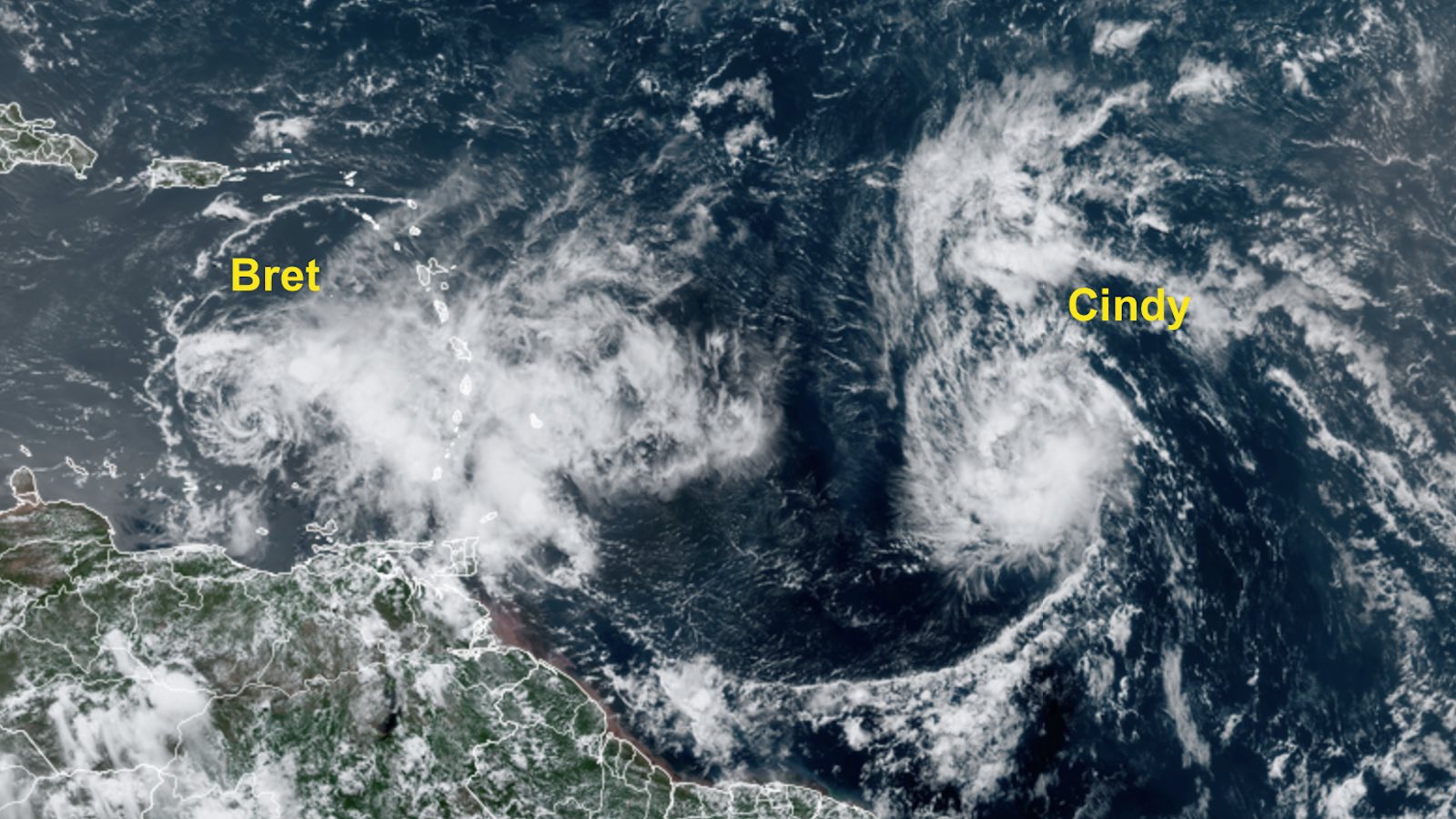
Tropical Storms Bret and Cindy are expected to have little impact over the next several days – except on the Atlantic’s hurricane-season annals – as they spin on either side of the Lesser Antilles.
Bret swept across the Windward Islands on Thursday night, June 22. After a slight southward jog before reaching the islands, the center of Bret passed about 15 miles north of Barbados and directly over St. Vincent. Hurricane-hunter flights pegged Bret’s top sustained winds at 60 miles per hour during its passage. Sustained winds of 44 mph gusting to 59 mph were reported at 5 a.m. Friday at Grantley Adams International Airport in Barbados. A gust to 69 mph was reported at 1 a.m. Friday at Hewanorra International Airport, on the south end of St. Lucia and just north of Bret’s center.
About 60% of the electrical grid on St. Lucia was knocked out by Bret, according to St Lucia Electricity Services Limited. Several homes were damaged or destroyed in St. Vincent and the Grenadines, as reported by journalist Anselm Gibbs. There were scattered reports of flash flooding into Friday from squalls and rainbands that continued to extend well east of Bret’s center, including on Trinidad.
As of 11 a.m. EDT Friday, Bret was located about 300 miles east-northeast of Curacao, accelerating to a forward speed of 21 mph as it continues moving west across the Caribbean. Bret’s top sustained winds remained pegged at 60 mph. However, Bret’s low-level center was fully exposed at times, as westerly wind shear was shoving much of Bret’s showers and thunderstorms (convection) well east of the storm.
Forecast for Bret
Bret’s future as a tropical cyclone looks increasingly dim. Although Bret will continue to track over very warm waters, the storm will experience increasing northwesterly wind shear that will drive dry air into the system and further compromise its already-jeopardized structure. The National Hurricane Center predicts that Bret will weaken below tropical-storm strength on Saturday night and dissipate by Sunday, though this may well occur even sooner. Some of Bret’s moisture and energy might manage to traverse Central America next week and feed into new development over the Northeast Pacific, as implied in Figure 1 below.

Tropical Storm Cindy joins the June club
Invest 93L was upgraded to become Tropical Storm Cindy on Thursday. Cindy is the fourth tropical or subtropical storm of the year, following a belatedly recognized subtropical storm from January and Tropical Storms Arlene and Bret. The average date of formation of the Atlantic’s fourth storm (1991-2020) is August 15. The record-earliest date is June 20 (Danielle in 2016); Cindy is now the second-earliest.
Cindy is also this month’s second named storm to develop east of the Caribbean – a first for any June on record. Moreover, it’s highly unusual to have two simultaneous named storms roaming anywhere in the Atlantic during June. On average, the month sees a named storm about every year or two. However, across NOAA hurricane data extending back to 1851, there have only been four instances of simultaneous tropical or subtropical cyclones in June, according to Phil Klotzbach (Colorado State University):
- 1909: June 27-30 (Tropical Storm Two and Tropical Storm/Hurricane Three)
- 1959: June 18 (Tropical Storm Beulah and Tropical Storm/Hurricane Three)
- 1966: June 30 (Tropical Storm Two and a subtropical storm that became Hurricane Becky)
- 1968: June 23-24 (Hurricane Brenda and Tropical Storm Candy)
At 11 a.m. EDT Friday, Cindy was located about 900 miles east of the Lesser Antilles at nearly the same latitude as Bret, moving west-northwest at 16 mph. Cindy’s top sustained winds were up to 50 mph, and the storm may intensify further over the next couple of days, as it takes advantage of light to moderate wind shear (5 to 10 knots) and the record- and near-record-warm June waters that now prevail over the tropical Atlantic. Cindy is also a smaller storm than Bret, which could allow it to strengthen as well as weaken more rapidly than Bret.
Cindy had a well-structured outflow pattern on satellite as of midday Friday, and convection was gradually consolidating around the center.

Forecast for Cindy
Steering currents will be fairly straightforward with Cindy over the next several days, taking the storm on a steady northwest course. As shown in Figure 2 above, forecast models are in strong agreement that Cindy will bypass the Caribbean islands, although swells could affect areas from the Lesser Antilles to the Bahamas over the coming days.
The sea surface temperatures along Cindy’s path will increase to 28-29 degrees Celsius (82-84 degrees Fahrenheit) as Cindy heads northwestward. In addition, the mid-level environment around Cindy will be moistening (relative humidity rising to around 60 percent). However, wind shear will also be increasing. NHC is now predicting that Cindy will plateau short of hurricane strength on Saturday and gradually weaken thereafter, though it wouldn’t be shocking to see Cindy make a brief run at category 1 hurricane strength.
There is some uncertainty over Cindy’s longer-term future. If Cindy survives the wind shear expected early next week, then conditions could then favor some reintensification over the subtropics beyond the official forecast period, as suggested by some of the GFS ensemble members in Fig. 2 above, as well as several runs of the operational GFS (though not the European model). The Atlantic waters ahead of Cindy around latitude 30 degrees north are exceptionally warm for late June, and many storms in recent years have vaulted to surprising strength while over the Atlantic subtropics.
Jeff Masters contributed to this post. Website visitors can comment on “Eye on the Storm” posts (see comments policy below). Sign up to receive notices of new postings here.
Source link