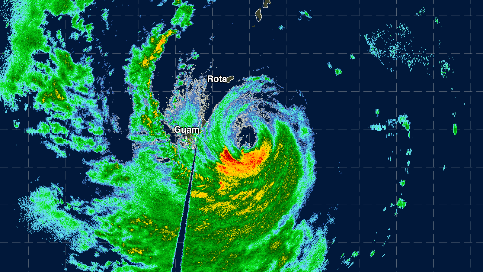
Ferocious Typhoon Mawar delivered a brutal pounding to the U.S. islands of Guam and Rota Wednesday as the storm’s center passed through the channel between the islands. At the time of its closest approach, between 6-12 UTC Wednesday, the Joint Typhoon Warning Center rated Mawar a category 4 storm with 130-140 mph winds. Mawar’s center passed about 15 miles north of the northern tip of Guam.
Guam caught a lucky break in the hours leading up to Mawar’s closest approach, when an eyewall replacement cycle caused the inner eyewall to collapse, weakening the typhoon’s peak winds from 155 mph to 130 mph. However, the storm’s typhoon-strength winds expanded and extended out 40 miles from the center to encompass the entire island of Guam. In addition, Mawar slowed down to just 6-8 mph as it passed the island.
Mawar’s southern eyewall moved over the northern portion of Guam for an extended period, and damage will be substantial there (the northern half of this island of 171,000 people is the more heavily developed portion). Damage to structures was likely limited somewhat by Guam’s unusually high prevalence of sturdy, reinforced concrete buildings. Because the highest storm surge from the typhoon was on the northern side of the eye, Guam avoided what would have been a large and very damaging storm surge. The center of Mawar passed about 25 miles south of the island of Rota (population 3,300), and that island likely received typhoon-force winds and a damaging storm surge.
The last wind reading from Guam International Airport was Wednesday at 7:54 p.m. local time (9:54 UTC): sustained winds of 71 mph, gusting to 105 mph. The station has continued to report rainfall and pressure, and the pressure bottomed out two hours later, at 970.9 mb. The airport received 12.54 inches of rain in the 53 hours ending at 12:38 a.m. Thursday local time. The weather station at Andersen Air Force Base, on the north end of Guam, stopped reporting early in the storm. The last observation was at 10:40 a.m. local time (0:40 UTC): sustained winds of 58 mph, gusting to 64 mph.
At 12Z Wednesday (8 a.m. EDT), Mawar was a category 4 storm with 140 mph winds (1-minute average), moving west at 6 mph, according to the Joint Typhoon Warning Center. The Japan Meteorological Agency, the official agency responsible for typhoon warnings in the Northwest Pacific, estimated that Mawar’s central pressure was 940 mb, with 110 mph winds (10-minute average, which is normally substantially lower than the 1-minute average). Rains were beginning to ease on Guam, though outer rainbands from the typhoon will bring several more inches of rain as the storm moves away.

Forecast for Mawar
Mawar is recovering from its eyewall replacement cycle, and satellite loops show that the typhoon has cleared out and symmetrized its eye, which had formerly been cloud-filled and irregularly shaped. Mawar has favorable conditions for intensification for the remainder of the week, with moderate wind shear of 10-20 knots and warm sea surface temperatures of 29-30 Celsius (84-86°F). Warm waters extend to great depth along Mawar’s track, giving it plenty of heat energy to draw upon for intensification. The Joint Typhoon Warning Center is predicting that Mawar will peak as a category 5 storm with 160 mph winds on Friday, then gradually weaken as it turns northwest over cooler waters. The Japan Meteorological Agency predicts that Mawar will peak with 10-minute sustained winds of 125 mph and a central pressure of 905 mb on Saturday. The 6Z Wednesday run of the HWRF model predicted Mawar’s peak intensity would be at 18 UTC Friday, as a category 4 storm with 150 mph winds and a central pressure of 921 mb.
Mawar is expected to track generally west-northwest for the remainder of the week, and potentially turn to the northwest early next week. It is too soon to dismiss a potential threat to the Philippines’ Luzon Island, whose northeastern portion now lies in the Joint Typhoon Warning Center and Japan Meteorological Agency five-day cones of uncertainty. Taiwan, Japan’s Ryukyu Islands, or mainland Japan could be a target for Mawar next week. Once the typhoon moves north of about 22 degrees north latitude (roughly parallel with Taiwan), the storm will encounter water temperatures below 26 degrees Celsius (79°F), which would cause substantial weakening.
Storm chasers Jim Edds and James Reynolds are on Guam and will likely provide updates once communications are reestablished.
Bob Henson contributed to this post. No post on Mawar is planned for Thursday.
Website visitors can comment on “Eye on the Storm” posts (see comments policy below). Sign up to receive notices of new postings here.
Source link