Hurricane Lisa was steadily intensifying in the Caribbean waters just east of Belize late Wednesday morning and is expected to make landfall in northern Belize on Wednesday afternoon as a category 1 hurricane. Meanwhile, Hurricane Martin reached hurricane status on Wednesday morning, giving the Atlantic two simultaneous November hurricanes for just the third time on record.
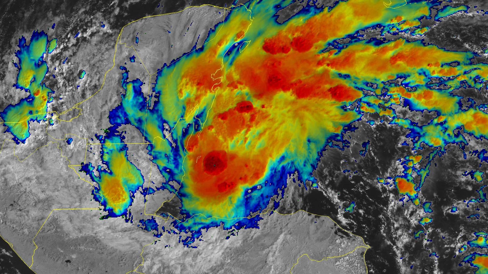
At 11 a.m. EDT Wednesday, Lisa was centered about 55 miles east-southeast of Belize City, Belize, heading west at 14 mph, with top sustained winds of 80 mph and a central pressure of 987 mb. Satellite images late Wednesday morning showed that Lisa’s heavy thunderstorms were bringing heavy rains to Belize, northern Guatemala, and Mexico’s Yucatán Peninsula.


Forecast for Lisa
The track forecast for Lisa is straightforward, with a strong ridge of high pressure to the northeast forcing a mostly westward motion, bringing Lisa to a landfall in Belize between 2-5 p.m. EDT Wednesday. Lisa will weaken as it crosses the Yucatán Peninsula and will likely be at tropical depression status when it emerges into the southern Gulf of Mexico’s Bay of Campeche on Friday morning. High wind shear of 20-30 knots is predicted on Friday over the Bay of Campeche, and the models predict that this shear will be high enough to cause Lisa to dissipate by Sunday or Monday without re-intensification occurring over the Gulf of Mexico.
Conditions will be favorable for intensification until Lisa makes landfall, with sea surface temperatures of 29 degrees Celsius (84°F) and moderate wind shear of 15-20 knots. Lisa will probably be an upper-end category 1 storm with 85-90 mph winds at landfall. Lisa is a relatively small hurricane, with hurricane-force winds that extend out just 10 miles from the center, and its most severe impacts – heavy rains of 4-6 inches, a storm surge of 4-7 feet, and damaging hurricane-force winds – will be restricted to a relatively small area near where the eyewall moves inland.
Belize has only been hit by two tropical storms and one hurricane in the month of November since records began in 1851. The only hurricane was an unnamed category 2 storm which made landfall on Nov. 9, 1942. The second-latest hurricane on record to hit Belize was category 4 Hurricane Hattie, which made landfall on Oct. 31, 1961.


Martin becomes a hurricane in the central Atlantic
Hurricane Martin took advantage of unusually warm sea surface temperatures of 25 degrees Celsius (77°F) – over two degrees Celsius (3.6°F) above average – to intensify into the Atlantic’s seventh hurricane of the 2022 season on Wednesday morning. At 11 a.m. EDT Wednesday, Martin was located about 790 miles south-southeast of Cape Race, Newfoundland, heading east-northeast at 26 mph, with top sustained winds of 75 mph and a central pressure of 983 mb.
Conditions are favorable for continued intensification of Martin, with cold air aloft expected to create enough instability to allow Martin to become a category 2 hurricane with 105-mph winds by Thursday morning. Martin will be short-lived, though – steering currents will take the storm to the northeast at a forward speed increasing to 40 mph by Thursday, carrying the hurricane over waters of just 12 degrees Celsius (54°F) by Thursday night. These cold waters are expected to cause Martin to transition to a hurricane-strength extratropical storm on Thursday night. Martin is not a threat to any land areas.
The ascension of Lisa and Martin to hurricane status brings this season’s activity to 13 named storms, seven hurricanes, and two major hurricanes, with an Accumulated Cyclone Energy (ACE) index 76% of average for the date. The 1991-2020 averages for Nov. 2 are 13.5 named storms, 6.7 hurricanes, and three major hurricanes, so 2022 is now near-average for the number of named storms and hurricanes, but below average for ACE and major hurricanes.
New tropical disturbance may soak the Southeast U.S. next week
A large and very unusual low-pressure system is forecast to form next week, as the counterclockwise flow around a sprawling low near the Bahamas is predicted to cause the trade winds over much of the central Caribbean to reverse from their usual easterly direction to blow out of the west. This nontropical low may acquire some tropical or subtropical characteristics early next week as it wobbles to the northwest toward the Southeast U.S. coast. The low is likely to bring a multiday period of strong onshore flow and intermittent heavy rains to much of the coast from Florida to North Carolina Monday through Thursday. The large size of the low, combined with marginal upper-level winds and temperatures, should make any development of the system slow to occur. In its 8 a.m. EDT Wednesday Tropical Weather Outlook, the National Hurricane Center gave the system 2-day and 5-day odds of development of 0% and 20%, respectively.
Website visitors can comment on “Eye on the Storm” posts (see comments policy below). Sign up to receive notices of new postings here.
Source link