When it comes to recent tropical cyclones in the Atlantic, it’s been quantity over quality lately. Over the last four days, the basin has churned out three named storms, yet it’s unlikely that any of these will approach hurricane strength. Still another disturbance, 98L, now organizing in the far eastern Atlantic, has a better shot.
Tropical Storm Peter angling away from Lesser Antilles
Tropical Storm Peter posed no major threat to the Caribbean on Monday as it angled northwest on a track that kept it well north of the northern Leeward Islands. Peter’s active weather was concentrated on its north and east sides, further reducing any potential impact. As of 11 a.m. EDT, Peter was centered about 170 miles northeast of Anguilla. Top sustained winds were 50 mph, but National Hurricane Center analysis showed that only the northeast quadrant of Peter with any substantial winds of tropical storm strength.


Peter’s asymmetry was the result of relentless 25-to-30-knot southwesterly wind shear from a nearby upper low that was keeping the storm dramatically tilted toward the northeast with height. On Monday morning, the storm’s low-level center was marooned roughly 100 miles west of Peter’s showers and thunderstorms. This distortion will keep Peter from any major strengthening, and model ensembles agree that Peter is destined to weaken, apart from the slight chance of a minor resurgence after it moves north of the strongest shear by midweek.
The National Hurricane Center forecast brings Peter to tropical-depression status by late Wednesday. If Peter somehow hangs together, it may approach the vicinity of Bermuda in about a week.
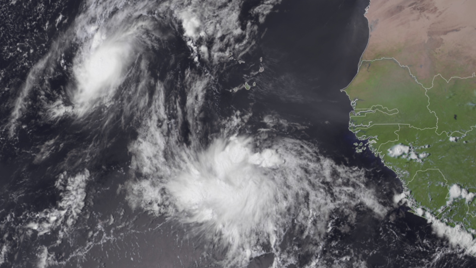
Rose likely to be a ‘fish’ storm
Tropical Storm Rose formed on Sunday afternoon in the far eastern tropical Atlantic. As of 11 a.m. EDT Monday, Rose was a minimal tropical storm with top sustained winds of 40 mph. Rose was about 600 miles west-southwest of the Cabo Verde Islands, moving northwest at 16 mph. This track is expected to continue for the next several days, taking Rose into the central tropical Atlantic, far from any land areas. So Rose is expected to be a “fish” storm – one concerning marine interests and not impacting land.
Conditions for intensification were marginal on Monday afternoon, with moderate wind shear of 10-20 knots, cool sea surface temperatures of 27 degrees Celsius (81°F), and a dry atmosphere. The NHC forecast calls for Rose to peak with 45 mph winds on Monday night, then steadily weaken as the system heads northwest and encounters cooler SSTs, higher wind shear, and a steadily drier atmosphere. Rose is expected to become a tropical depression by Wednesday if not sooner. If nothing else, Rose is giving the NHC hurricane specialists a chance to arrange some flowery prose in their forecast discussions.
Two other systems to watch
On the heels of Rose, another tropical wave that emerged off the African coast late Sunday could develop later in the week. This wave, which the NHC designated 98L, was about 300 miles south-southeast of the Cabo Verde Islands on Monday morning. Satellite images showed 98L growing more organized, with a pronounced spin and an expanding area of heavy thunderstorms. The wave will move westward at 10-15 mph this week across the tropical Atlantic at a lower latitude than Rose, potentially giving it more chance of entering the Caribbean.
98L has strong model support for development, and conditions appear quite favorable for 98L to intensify throughout the week. Wind shear is predicted to remain below 10 knots except from Tuesday into Wednesday, when it could reach 10-15 knots, and SSTs along 98L’s path are expected to remain at or above 28 degrees C (82°F). Moreover, mid-level relative humidity will remain high, above 70%, through at least Thursday. The 12Z Monday run of the SHIPS model makes 98L a tropical storm by Wednesday, as did the 06Z Monday runs of the HWRF and HMON models.
in its tropical weather outlook issued at 2 p.m. EDT Monday, the NHC gave it 2-day and 5-day odds of development of 30% and 80%, respectively. The next name on the Atlantic list of storms is Sam.
Meanwhile, it’s still possible that remnants of Tropical Storm Odette, declared post-tropical south of Nova Scotia on Saturday evening, will regroup later this week as a subtropical cyclone as they arc southeastward atop warmer waters. In that case, the name Odette would most likely be revived. The NHC gave 10% odds of such development by Wednesday and 30% odds between Thursday and Saturday. By the end of the week, Odette is expected to move northward over colder waters and finally lose any of the tropical characteristics that it could briefly reacquire.
Entering uncharted territory on this year’s list of Atlantic names
According to Phil Klotzbach of Colorado State University, since accurate satellite records began in 1966, only two other seasons have had as many as 17 named storms by September 19: 2020 and 2005. So far in 2021, the Atlantic has had 17 named storms, six hurricanes, and three major hurricanes. The 1991-2020 averages were 14.4 named storms, 7.2 hurricanes, and 3.2 major hurricanes, so by several metrics, 2021 already has had a full season of activity – and there’s over 40% of the season to go! This makes it likely that we will run through the full list of 21 names for the second year in a row.
Only four names remain in the 2021 list of storms: Sam, Teresa, Victor, and Wanda, none of them ever used in Atlantic tropical history (as was the case with Rose until it was used for the first time on Sunday).
Website visitors can comment on “Eye on the Storm” posts. Please read our Comments Policy prior to posting. Comments are generally open for 30 days from date posted. Sign up to receive email announcements of new postings here. Twitter: @DrJeffMasters and @bhensonweather
Source link