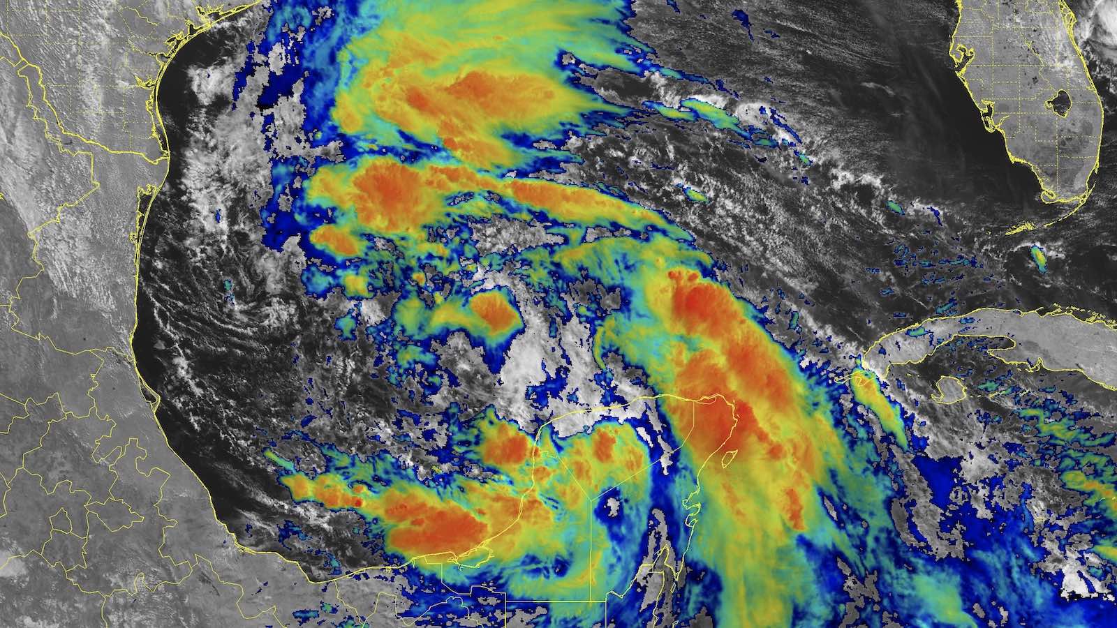
The first tropical storm warnings of the Atlantic hurricane season are up for portions of the coasts of southern Texas and northeastern Mexico, as Potential Tropical Cyclone 1 (PTC 1) heads toward a potential landfall in the warned area on Wednesday night. PTC 1 will likely organize into the season’s first tropical storm by Wednesday as it moves west to west-northwest at less than 10 mph toward the coast. A hurricane hunter aircraft was investigating the system Tuesday afternoon.
At 11 a.m. EDT Tuesday, PTC 1 was located about 410 miles southeast of Brownsville, Texas, headed north at 5 mph with a central pressure of 999 mb and top sustained winds of 40 mph. Although these winds were already at minimal tropical storm strength, PTC 1 did not yet have the focused circulation required to merit being classified as a tropical storm. In fact, gale-force winds extended up to 250 nautical miles (287 miles) north of PTC 1’s ill-defined center but were nearly absent to the west, east, and south. Satellite images on Tuesday afternoon showed PTC 1 as a broad area of rotation in the Bay of Campeche. Heavy thunderstorm activity was clumpy and scattered but was slowly growing more organized.
Conditions in the southern Gulf of Mexico were quite favorable for development. Sea surface temperatures were near record-warm for mid-June, about 30 degrees Celsius (86°F); wind shear was a light 5-10 knots; and the atmosphere was very moist, with a midlevel relative humidity of 75%. The sprawling nature of the system will initially keep development slow to occur, but the topography of the surrounding coast can help get PTC 1 spinning.


Forecast for PTC 1
The GFS and European models and their ensembles remain in strong agreement that PTC 1 will develop into a tropical storm over the southern Gulf of Mexico’s Bay of Campeche by Wednesday, then move onto the coast of northeast Mexico a few hundred miles south of the Texas border by Wednesday night. Increasing wind shear and a short time over water will likely prevent much intensification, but the system has favorable enough conditions to become Tropical Storm Alberto, if only for a few hours before landfall. The average date of the arrival of the Atlantic’s first named storm is June 20, based on the 1991-2020 period; however, it has been a full decade (2014) since an Atlantic season made it as far as today (June 18) without its first named storm.
Regardless of whether or not PTC 1 gets named, its primary threat will be heavy rains in excess of four inches that will fall along a large swath of coasts of Mexico and Texas through Thursday. Lesser rains of one to four inches are likely along the southwestern Louisiana coast. Heavy rains from PTC 1 are already being blamed for 11 deaths in El Salvador, and two in Guatemala.
Highly destructive winds are not expected from PTC 1, but because of its starkly asymmetric structure, winds above the tropical storm threshold (39 mph) could reach the Texas coast far to the north of the expected landfall on the Mexican coast – perhaps even farther north than official predictions, as noted by the National Hurricane Center in its 11 a.m. EDT Tuesday forecast discussion.
The PTC 1 disturbance is part of a larger area of disturbed weather called a Central American Gyre spinning over Central America. This week the counterclockwise flow of air around the Central American Gyre will be pulling copious amounts of moisture over Central America and southeastern Mexico from portions of the Eastern Pacific where water temperatures are about 1 degree Celsius (1.8°F) above average. Most of Central America and Mexico experienced their hottest spring (March-May) on record, heating the surrounding waters to record levels. These record-warm waters will be able to supply a record amount of moisture to the atmosphere. This moisture-laden air will be forced upward by the high terrain along the coast, resulting in torrential rains along the Pacific coasts of El Salvador, Guatemala, and southern Mexico. NHC is predicting total rainfall amounts of up to 20 inches for some of these mountainous regions (Fig 2).


Rinse and repeat?
The GFS and European models and their ensembles are predicting that another disturbance will develop in the southern Gulf of Mexico’s Bay of Campeche late this week, and then potentially develop into a tropical storm that would bring additional heavy rains to South Texas and northeastern Mexico early next week. In its Tropical Weather Outlook issued at 8 a.m. EDT Tuesday, NHC gave this future system 2-day and 7-day odds of development of 0% and 20%, respectively.
Also being monitored is a disturbance east of the Bahamas, along the tail end of a decaying front, that is moving slowly toward the Southeast U.S. coast. This disturbance is enmeshed in a weak upper low, an unfavorable setup for tropical cyclone formation, and the European and GFS forecast model ensembles as of early Tuesday were providing very little support for development. The latest NHC outlook gave this system 10% and 20% odds of development in the 2- and 7-day periods, respectively.
The next two names on the 2024 Atlantic list after Alberto are Beryl and Chris.
We help millions of people understand climate change and what to do about it. Help us reach even more people like you.
Source link


