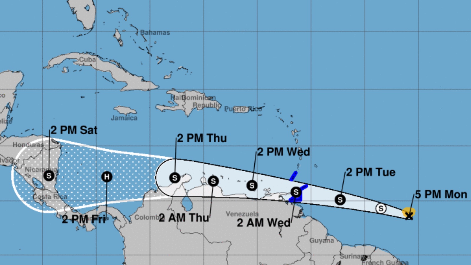
Tropical storm warnings have been hoisted for Trinidad, Tobago, and Grenada and its dependencies as of 5 p.m. EDT Monday, in advance of a slow-developing disturbance designated Potential Tropical Cyclone 2 by the National Hurricane Center. Moving west-northwest about 18 mph, PTC 2 is expected to cross the southernmost Lesser Antilles early Wednesday as a tropical depression or weak tropical storm, with additional strengthening predicted as it moves across the southern Caribbean. PTC 2’s top sustained winds as of 5 p.m. Monday were 40 mph.
A reconnaissance mission on Monday afternoon found tropical-storm-strength winds on the north side of an elongated wave centered at 5 p.m. at 8.6°N, 50.9°W, or about 720 miles east of Trinidad. However, the system did not have the distinct closed low-level circulation (including westerly winds on its south side) needed to classify it as a tropical cyclone.
A large shield of showers and thunderstorms (convection) cradled PTC 2 on Monday afternoon. The convection may intensify on Monday night during the nighttime peak of convection typical for systems in the deep tropics.


Forecast for PTC 2
PTC 2 is expected to gradually organize over the next couple of days as it remains embedded in a favorable environment: warm sea surface temperatures (SSTs) of around 28 degrees Celsius (81°F), light wind shear below 10 knots, and a moist mid-level atmosphere (relative humidity of 65-70%). The strong wind shear that typifies the eastern Caribbean during June will be notably scarce this week, giving PTC 2 an unusually high chance of development for the location and time of year.
As discussed in our Sunday post, only three tropical depressions, two tropical storms, and two hurricanes have been recorded between the eastern Caribbean and Africa during the month of June in 172 years of recordkeeping; none of these systems originated as a tropical cyclone in the eastern Caribbean.
The operational GFS and European computer models and their ensemble members were in close agreement Monday morning that PTC 2 would move across the southern half of the Caribbean late this week, perhaps approaching the coast of Nicaragua this weekend. At first, any strengthening will be gradual, as PTC 2 will be moving near or even over the coast of South America. Rainfall of 4-6” is possible across the southermost Lesser Antilles and in far northern Venezuela and Colombia. The chance of more extreme rains in South America will be lower the more the center remains just offshore, as the coast would then be on the weaker left-hand side of PTC 2.
Assuming it holds together, PTC 2 will have a chance at more robust strengthening late this week, after it clears South America and heads toward Central America. The NHC outlook issued at 5 p.m. Monday projects that PTC 2 will strike Nicaragua at hurricane strength on Saturday.
Short-range intensity models such as HWRF and HMON will become much more helpful after PTC 2 becomes a tropical cyclone (assuming it does). The extent of land interaction with South America will be crucial in determining PTC’s future beyond Wednesday.


The wave behind PTC 2
A rich field of moisture stretching across the intertropical convergence zone from the eastern Caribbean to Africa (see Figure 2) was peppered with multiple disturbances on Monday, resembling late August or September more than late June. Dust and dry air from the Saharan Air Layer were displaced well north of this belt, allowing PTC 2 to take shape.
Right on the heels of PTC 2, there’s another energetic tropical wave centered around latitude 8°N, longitude 38°W, with a smaller concentration of convection. Any development should be slow to occur, especially with PTC 2 taking shape just to the west, but NHC tagged this disturbance on Monday afternoon with a 10% chance of development into at least a tropical depression by Wednesday and a 20% chance through Saturday.
If this wave does develop, it could be just close enough to PTC 2 to raise consideration of the Fujiwhara effect – the tendency of two tropical cyclones separated by less than 800 mi (1300 km) to rotate around each other or to merge with each other. Models are suggesting that any such influence would be subtle, tending to displace the more eastern tropical wave slightly north of PTC 2’s track as the former moves west-northwest. There is modest support among the GFS and European ensemble runs for this wave (perhaps merging with yet another vigorous wave just behind it) to become a tropical depression or weak tropical storm late this week as it nears the Lesser Antilles.
The environment for this wave should be comparable to that of PTC 2 – plenty of mid-level moisture, relatively low wind shear, and warm SSTs – so development is certainly possible, especially once PTC 2 is far enough away to minimize any suppressing influence. Residents of the Leeward Islands will want to monitor this system, especially later this week.
A drought-easing disturbance will move along the northwest Gulf Coast
NHC has also been keeping tabs on a complex of showers and thunderstorms working their way along the Louisiana coast on Monday afternoon. The convection is at the southward end of a decaying cold front, but as it drifts southwest, it may organize into a more distinct area of low pressure. A few members of the GFS and European ensemble angle this system northwest as a weak disturbance into the Texas coast by Thursday. Regardless of development, several inches of rain will be possible along and near the Texas and Louisiana coasts this week. These rains likely will be more beneficial than harmful, as much of the region’s coastal plain is currently plagued by moderate to extreme drought.
On Monday afternoon, NHC gave this system a 10% chance of development through Thursday and a 20% chance through Saturday. Especially given that SSTs are exceptionally warm for late June off the Texas and Louisiana coast, tropical cyclone development here is possible, but ensemble models suggest anything that might form is likely to remain on the weak side.
A thunderstorm complex spins over the Bahamas
An upper-level area of low pressure over the eastern Bahamas is yet another area to watch this week. The spin from this low was clearly evident on visible satellite loops, with southwesterly shear pushing convection toward its northeast side. Such systems do not typically develop into tropical cyclones unless the low pressure can “drill down” to the surface, and none of the reliable models or ensembles are predicting development. However, the system may enhance typical summertime convection over Florida as it drifts south and west.
Jeff Masters contributed to this post.
Website visitors can comment on “Eye on the Storm” posts. Please read our Comments Policy prior to posting. Comments are generally open for 30 days from date posted. Sign up to receive email announcements of new postings here. Twitter: @DrJeffMasters and @bhensonweather
Source link