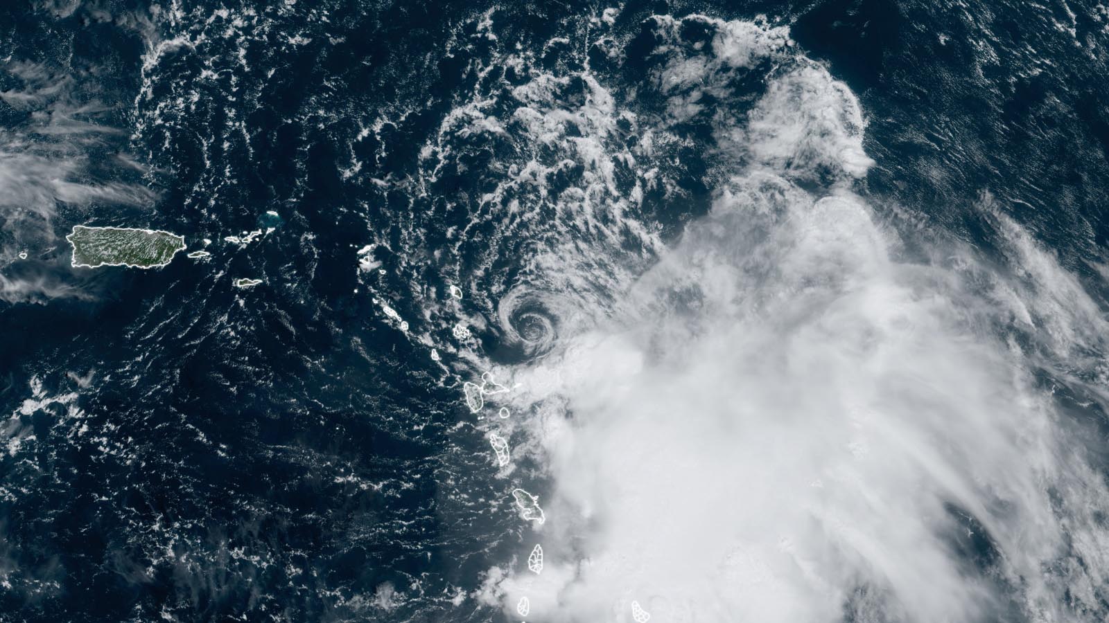
A Tropical Storm Warning is up for Barbuda and a Tropical Storm Watch for Antigua in the Leeward Islands, where Tropical Storm Philippe is expected to dump heavy rains capable of causing damaging flash flooding and landslides over the next two days.
At 11 a.m. EDT Monday, Tropical Storm Philippe was located about 80 miles east-southeast of Barbuda in the northern Leeward Islands, headed west-northwest at 7 mph, with top sustained winds of 50 mph and a central pressure of 1000 mb. Barbados radar showed that Philippe was bringing bands of heavy rains to portions of the Lesser Antilles.
Satellite images showed an unhealthy tropical storm, with a low-level center fully exposed to view and high wind shear keeping all of Philippe’s heavy thunderstorms confined to the southeast side of the storm.
Forecast for Philippe
The forecast for Philippe is relatively straightforward thanks to the demise of Tropical Storm Rina, which was declared post-tropical on Sunday night. Phillipe is expected to move west-northwest to north-northwest through Tuesday, bringing the center very close to the northern Leeward Islands on Monday night. The main threat to the islands will be heavy rains, with four to six inches predicted for Antigua and Barbuda, with lesser amounts elsewhere in the islands. The heaviest rains will likely occur Tuesday afternoon. Intensification of Philippe is not expected through Tuesday because of high wind shear, fortunately. If Philippe angles a bit more westward than predicted along its track — which was the case throughout the weekend — then it would not be a surprise if some of Philippe’s heavier squalls nudged into or near Guadeloupe, Dominica, and/or Martinique.
Beginning on Wednesday, when Philippe will be pulling away from the islands, wind shear is predicted to relax, allowing for some modest strengthening. The National Hurricane Center, or NHC, forecast calls for Philippe to become a hurricane on Friday, when it will be in the remote central Atlantic. The eventual fate of Philippe is unclear, with the European model predicting a continued northerly track and eventual threat to Atlantic Canada early next week but the GFS model predicting a turn to the east, keeping the storm far away from Canada. A stronger storm is more likely to turn east and miss Canada, while a weaker storm is more likely to head north and affect Canada.
Eastern Pacific heating up
As is often the case, when the Atlantic tropical storm activity gets quiet, the Eastern Pacific heats up. That’s expected to be the case this week. Forecasters are watching an area of disturbed weather located a few hundred miles off the Pacific coast of Mexico, designated Invest 98E. This system is expected to become a tropical depression on Monday and could become a landfall threat for Mexico by early next week. In their 8 a.m. EDT Monday Tropical Weather Outlook, NHC gave 98E two-day and seven-day odds of development of 90% and 100%, respectively.
Long-range forecast models are predicting development of another system in the eastern Pacific later this week in the waters a few hundred miles south of the region near the Mexico-Guatemala border. In their 8 a.m. EDT Monday Tropical Weather Outlook, NHC gave this future disturbance two-day and seven-day odds of development of 0% and 60%, respectively. The next two names on the eastern Pacific list of storms are Lidia and Max.
It’s been a near-average hurricane season in the eastern Pacific so far in 2023, with 11 named storms, seven hurricanes, five major hurricanes, and an accumulated cyclone energy (ACE) index of 122.5. The 1991-2020 averages for this point in the season are 14 named storms, 7.6 hurricanes, four major hurricanes, and an ACE index of 113.8.
Typhoon Koinu takes aim at Taiwan
In the western Pacific, powerful Typhoon Koinu is headed for Taiwan. According to the Joint Typhoon Warning Center, at 8 a.m. EDT Monday, Koinu’s top sustained winds were 125 mph, making it a high-end category 3 storm. Koinu, which means “puppy” in Japanese, has likely peaked in strength, as dry air and higher wind shear were beginning to affect the typhoon, and will increase through Wednesday. The Joint Typhoon Warning Center is predicting a landfall in southern Taiwan on Wednesday morning (U.S. Eastern Time) as a Category 2 storm with 105 mph winds.
It was an unusually quiet September in the western Pacific, which tied its record for fewest named storms for the month, with just two (see Tweet above). By most measures, though, it’s been a near-average typhoon season in the western Pacific so far in 2023, with 13 named storms, 10 typhoons, seven major typhoons, and an accumulated cyclone energy (ACE) index of 217. The 1991-2020 averages for this point in the season are 18.8 named storms, 11.4 typhoons, 6.3 major typhoons, and an ACE index of 201.
Last month, the western Pacific and eastern Pacific generated a mere 19 and 18 units of ACE, respectively, whereas the Atlantic — turbocharged by record and near-record sea surface temperatures — pumped out 74 units, according to Phil Klotzbach at Colorado State University. As Klotzbach pointed out on Twitter/X: “Definitely not a typical #ElNino signal when the Atlantic generates double the Pacific ACE during September!”
Bob Henson contributed to this post. Website visitors can comment on “Eye on the Storm” posts (see comments policy below). Sign up to receive notices of new postings here.
Source link


