Tropical Storm Sam formed at 11 a.m. EDT Thursday, and it is predicted to intensify into a powerful long-track Cape Verde-type hurricane that could threaten the Caribbean by the middle of next week. It is too early to know if Sam might threaten the U.S. or Canada.
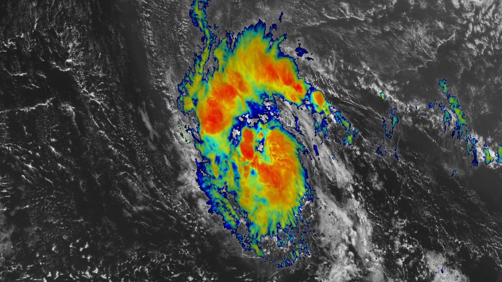
At 11 a.m. Thursday, Sam was in the central tropical Atlantic about 1,745 miles east-southeast of the Leeward Islands, headed west at 16 mph with top winds of 50 mph and a central pressure of 1003 mb. Satellite images showed Sam becoming well-organized, with a concentrated area of heavy thunderstorms wrapping around a well-defined surface circulation.
Intensity forecast for Sam
Sam has strong model support for intensification, and conditions appear quite favorable for it to intensify throughout the next three days. Wind shear is predicted to be light (5-10 knots), sea surface temperatures (SSTs) will be at least 28.5 degrees Celsius (83°F), and the atmosphere is predicted to be reasonably moist, with a mid-level relative humidity of 50-60%. The National Hurricane Center (NHC) forecast is aggressive, calling for Sam to become a hurricane on Friday and a major hurricane on Sunday. The 12Z Thursday run of the SHIPS model gave a 39% chance that Sam would intensify into a 120-mph category 3 hurricane by Sunday morning; the experimental DTOPS model gave that prospect a 51% chance of occurring.


Track forecast for Sam
Sam is predicted to track west to west-northwest at 10-15 mph and gradually slow down over the next week, potentially making it a threat to the Lesser Antilles Islands in six to seven days. The future track will depend heavily on how quickly Sam develops, and how strong it gets. A stronger storm is more likely to feel steering currents aloft that will tug Sam farther to the north and miss the Lesser Antilles; a weaker and slower-to-organize storm will track farther to the west and potentially pass through the islands.
Sam’s future track will depend also on the timing and strength of troughs of low pressure passing to the north along the jet stream next week. One wild card in this forecast is the potential perturbations to the jet stream created by Tropical Storm Mindulle in the Northwest Pacific. Mindulle is predicted to intensify into a powerful category 4 typhoon that will recurve to the north near Japan next week. When Mindulle merges with the jet stream, it is likely to cause a major ripple effect in the jet that could influence the steering of Sam.
The 0Z and 6Z Thursday runs of the GFS and European model ensembles showed Sam a potential threat to the Leeward Islands by the middle of next week, with the storm likely making its closest approach to the northeastern Leeward Islands on Wednesday. Thursday’s model runs showed less of a threat to the Leeward Islands than they did on Wednesday, with Sam’s core more likely to pass to the northeast. The models have been consistently showing that a stronger storm will track more to the north, missing a direct impact to the islands. If Sam does intensify into a major hurricane, as the NHC has predicted, its track would more likely carry it to the north of the islands.
Entering uncharted territory on this year’s list of Atlantic names
According to Phil Klotzbach of Colorado State University, only the 2020 season has had as many as 18 named storms by September 23. In that insanely active year, we’d already burned through the full list of 21 names by September 23, and were two letters into the Greek alphabet (Beta). So far in 2021, the Atlantic has had 18 named storms, six hurricanes, and three major hurricanes, compared to 1991-2020 averages of 14.4 named storms, 7.2 hurricanes, and 3.2 major hurricanes. On average, we should expect to see six more named storms after September 23, making it likely we will run through the full list of 21 names for the second year in a row. Only three names remain in the 2021 list of storms: Teresa, Victor, and Wanda, none of them ever used in Atlantic tropical history.
Ex-Odette close to regaining its name
Tropical Storm Peter and Tropical Storm Rose both met their demise overnight, and the only other system of concern to become a tropical cyclone over the next two days is the remnants of Tropical Storm Odette, located about 600 miles west-northwest of the Azores Islands. Ex-Odette was over marginally warm waters of 23-24 degrees Celsius, warm enough to help generate an increasing amount of heavy thunderstorm activity, as seen on satellite imagery.
In its 8 a.m. EDT Thursday Tropical Weather Outlook, the NHC gave ex-Odette 2-day and 5-day odds of regeneration of 60%. This weekend, Odette is expected to encounter high wind shear and finally lose any of the tropical characteristics it could briefly reacquire.
Next week, watch for tropical wave to emerge from coast of Africa
A new tropical wave is expected to emerge from the coast of Africa by Sunday. This wave has strong model support for development next week, when the system will be moving west at 10-15 mph over the eastern tropical Atlantic. In its 8 a.m. EDT Thursday Tropical Weather Outlook, the NHC gave the new wave 2-day and 5-day odds of development of 0% and 20%, respectively.
Bob Henson contributed to this post.
Website visitors can comment on “Eye on the Storm” posts. Please read our Comments Policy prior to posting. Comments are generally open for 30 days from date posted. Sign up to receive email announcements of new postings here. Twitter: @DrJeffMasters and @bhensonweather
Source link