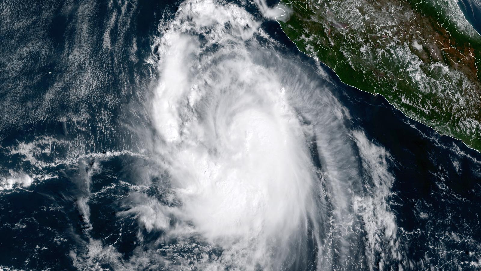
A Hurricane Watch is up for the west-central coast of Mexico as rapidly strengthening Tropical Storm Pamela grows more organized over the unusually warm waters off the Pacific coast of Mexico. Pamela is expected to brush the southern tip of the Baja Peninsula on Tuesday night and be a dangerous landfalling major hurricane in mainland Mexico on Wednesday.
At 11 a.m. EDT Monday, Pamela was about 455 miles south-southwest of Mazatlan, Mexico, headed northwest at 8 mph, with top winds of 65 mph and a central pressure of 995 mb. Conditions were favorable for development, with moderate wind shear near 10-15 knots, a moist atmosphere, and very warm waters near 30 degrees Celsius (86°F). Even more favorable conditions are expected Monday night through Tuesday morning, when an upper-level wind pattern with lower wind shear and improved outflow is expected to develop.


Pamela is expected to respond to the steering influence of a trough of low pressure passing to its north by recurving to the northeast, passing just south of the southern tip of the Baja Peninsula on Tuesday night. It appears that the core of the storm will pass well to the south of Baja, but in its 11 a.m. EDT Monday wind probability forecast, the National Hurricane Center gave San Jose del Cabo on the southern tip of Baja a 3% chance of receiving hurricane-force winds, and a 46% chance of tropical storm-force winds.
As Pamela approaches the coast of mainland Mexico on Wednesday morning, the waters beneath it will warm to a scorching 31 degrees Celsius (88°F) – over one degree Celsius above average. This ocean warmth results, in large part, from an exceptional heat wave that has brought near-record heat to western Mexico in recent weeks. Warm water along portions of Pamela’s path extend to a substantial depth, with a total ocean heat content in excess of 100 kilojoules per square centimeter, a value commonly associated with rapid intensification of hurricanes.
Although this hot water will favor intensification, Pamela will be wrapping a substantial amount of dry air off the deserts of Mexico into its circulation beginning on Tuesday, and there may be enough wind shear present to allow this dry air to penetrate the core of the storm and weaken it. Many of the top intensity models show Pamela intensifying to a category 2 or 3 hurricane, and category 4 strength is not out of the question, as predicted by the 6Z Monday run of the HWRF model. The experimental intensity density forecast from MIT using the GFS ensemble model predicted that a reasonable peak intensity for Pamela would be between 105 and 140 mph winds.
Pamela is predicted to make landfall Wednesday within 100 miles of Mazatlán, with the National Hurricane Center forecast calling for a category 3 storm with 120 mph winds just before landfall. In its 11 a.m. EDT Monday wind probability forecast, NHC gave Mazatlán a 28% chance of receiving hurricane-force winds, and an 85% chance of tropical storm-force winds. Mazatlán has a population of about 500,000.
The first hurricane hunter mission into Pamela is scheduled for Tuesday morning.


Disturbance 93L in tropical Atlantic headed toward the Lesser Antilles
A tropical wave about 350 miles east-southeast of the Windward Islands at 8 a.m. EDT Monday was headed west-northwest at roughly 15 mph. This system, designated 93L, had marginal conditions for development, with high wind shear of 20-25 knots. Satellite images on Monday afternoon showed 93L had developed some rotation at mid-levels of the atmosphere, but no surface circulation was evident. The system had a modest number of heavy thunderstorms but was struggling with dry air ingestion.
On Tuesday and Wednesday, when 93L will be near the Lesser Antilles Islands, steering currents are predicted to be weaker, causing a slow motion at roughly 5 mph to the northwest or north. 93L has little model support for development, but it will bring heavy rains and gusty winds to much of the Lesser Antilles Islands on Tuesday and Wednesday. In its 8 a.m. EDT Monday Tropical Weather Outlook, NHC gave 93L 2-day and 5-day odds of development of 20%.
Eastern Caribbean disturbance not expected to develop
A tropical wave in the eastern Caribbean a few hundred miles south of the Dominican Republic on Monday afternoon was headed northwest at about 5-10 mph. This system had not yet been labeled by the NHC, and it had marginal conditions for development, with high wind shear of 25-30 knots. Satellite images on Monday afternoon showed the system had developed some rotation at low levels of the atmosphere, but had very little heavy thunderstorm activity.
By Wednesday, when the system will be over the southeastern Bahamas, wind shear may decrease enough to support development. However, the wave has little model support for development, and in its 8 a.m. EDT Monday Tropical Weather Outlook, NHC gave the system 2-day and 5-day odds of development of 0% and 20%, respectively.
Southern Plains walloped by tornadoes, high wind, hail on Sunday
A stout “second season” episode of severe weather tore across the Plains landscape from northern Texas to southwest Missouri on Sunday night. No catastrophic damage or serious injuries were reported, but an intense tornadic supercell thunderstorm rolled across southwest Oklahoma into the Oklahoma City metro area, merging into a powerful squall line by late evening. Around 14,000 customers in Oklahoma lost power on Sunday night, according to the Oklahoman and Oklahoma Gas & Electric.
After filtering out duplicate reports, NOAA’s National Weather Service Storm Prediction Center reported 12 tornadoes from Sunday evening into early Monday morning, all causing mostly minor damage. Confirmation of all of these twisters would be enough to meet one informal definition of a tornado outbreak: six tornadoes separated by no more than six hours each.
As it happens, there is no “official” definition of a tornado outbreak. In a paper on this long-debated topic published this April in the Bulletin of the American Meteorological Society, Paulina Cwik and colleagues concluded, “Perhaps to the dismay of some scholars, there is no one consistent, unequivocal definition of a tornado outbreak – nor, we believe, should there be.”
Sunday’s priciest damage likely came from a swath of large hail (up to 3 inches in diameter) that swept across northern parts of Norman, Oklahoma, home to the Storm Prediction Center.
Only six months earlier, on April 28, a major hailstorm had shredded some of the same parts of Norman. It was part of a two-day hail-dominated severe weather outbreak that wreaked $3.2 billion in damage in Texas and Oklahoma, the nation’s third costliest weather disaster so far this year behind the February cold wave and Hurricane Ida.
More severe weather ahead
The active October pattern will continue for several more days, as a powerful upper-level trough reloads in the western United States. All severe hazards, including tornadoes, are possible Monday from eastern Missouri and Illinois into northern Michigan ahead of a cold front sweeping from the Plains into the Midwest. The Storm Prediction Center has placed this area under a slight risk (fourth highest of the five categories), implying that the coverage of severe weather will likely not be widespread.
As Monday’s front washes out, a new surface low and front will rapidly take shape on Tuesday in the Southern Plains. An enhanced risk (third highest category) is in effect, mainly for a wind-generating squall line expected to form by late evening from southern Nebraska to north Texas.
Website visitors can comment on “Eye on the Storm” posts. Comments are generally open for 30 days from date posted. Sign up to receive email announcements of new postings here. Twitter: @DrJeffMasters and @bhensonweather
Source link