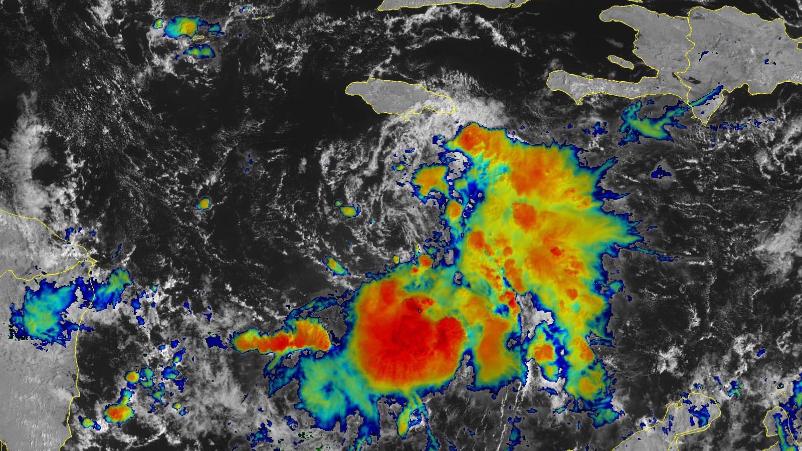
Tropical Storm Lisa, the 12th named storm of the 2022 Atlantic hurricane season, formed at 11 a.m. EDT Monday, Oct. 31, in the waters a few hundred miles south of Jamaica. Lisa is predicted to hit Belize on Wednesday as a category 1 hurricane.
At 11 a.m. EDT Monday, Lisa was centered about 175 miles south of Kingston, Jamaica, heading west at 14 mph, with top sustained winds of 40 mph and a central pressure of 1003 mb. Satellite images and Cayman Islands radar showed that most of Lisa’s heavy thunderstorms were limited to the east side of the center, with a low-level spiral band bringing heavy rains to Jamaica. The lack of heavy thunderstorms on the storm’s west side resulted from strong upper-level winds out of the west that were creating a moderate 15 knots of wind shear.
Lisa’s formation comes almost two weeks after the average development date of the Atlantic’s 12th named storm of the year, October 11. This season’s activity now stands at 12 named storms, five hurricanes, and two major hurricanes, with an Accumulated Cyclone Energy index only 73% of average for the date. The 1991-2020 averages for October 31 are 13.4 named storms, 6.6 hurricanes, and three major hurricanes. So despite the catastrophic rampage of Hurricane Ian, the Atlantic as a whole is having a less active season than usual by most metrics.
Forecast for Lisa
The track forecast for Lisa is relatively uncomplicated, with a strong ridge of high pressure to its north forcing a mostly westward motion this week, bringing Lisa to a landfall in Belize. The models are in good agreement on Lisa’s forward speed, with the storm expected to make landfall late afternoon or early evening on Wednesday.
Conditions will be mostly favorable for intensification until Lisa makes landfall, with sea surface temperatures of 29-30 degrees Celsius (84 – 86°F) and low to moderate wind shear of 5-15 knots. However, the atmosphere surrounding the storm is relatively dry (a midlevel relative humidity of 60%, forecast to increase to 70% by Wednesday), and this dry air should limit Lisa’s potential for rapid intensification. The 12Z Monday run of the SHIPS and DTOPS models gave Lisa just an 8% by Tuesday morning of meeting the definition of rapid intensification – a 35-mph increase in winds in 24 hours. These models did, however, give Lisa a 17% chance of becoming a major hurricane with 115 mph winds before landfall on Wednesday.
Lisa a modest heavy rain threat by Central American standards
Lisa is a relatively small storm and is not expected to dump much rain compared to a typical tropical storm or hurricane affecting Central America. Larger storms can tap into the eastern Pacific and draw moisture from both the Pacific and the Atlantic to generate dangerously high rainfall amounts. Lisa’s circulation is too small to do that. The National Hurricane Center is predicting peak rainfall amounts of 3-5 inches with isolated amounts of up to 8 inches in Belize and lesser amounts in surrounding nations. Most of Belize has experienced below-average rainfall over the past month, so saturated soils that would encourage rapid flooding are not present.
Central America still cleaning up from Hurricane Julia
Lisa is predicted to track to the north of where Hurricane Julia had the most impact earlier this month, and Lisa is unlikely to be as deadly or destructive as Julia. Julia made landfall in northeastern Nicaragua on Oct. 9 as a category 1 hurricane with top sustained winds of 85 mph. Widespread flooding hit the Nicaraguan capital of Managua when Julia passed only about 20 miles north of town, and Nicaragua suffered over $400 million in damage and five deaths. Julia brought heavy rains and deadly flooding to much of Central America, with 35 deaths being blamed on the storm in five Central American nations.
Two days after Julia brought heavy rain to northern Venezuela, a subsequent burst of rain led to severe flash flooding on a mountainside whose soils had been destabilized by Julia’s heavy rains, unleashing a major landslide in Las Tejerías (population 54,000). The landslide killed 54 and left eight missing.
Website visitors can comment on “Eye on the Storm” posts (see comments policy below). Sign up to receive notices of new postings here.
Source link


