Tropical Storm Lee rapidly intensified by 35 mph in the 24 hours ending at 11 a.m. EDT Wednesday, and by Friday is expected to become a classic long-track Cabo Verde-type major hurricane – the most powerful and dangerous class of Atlantic hurricanes.
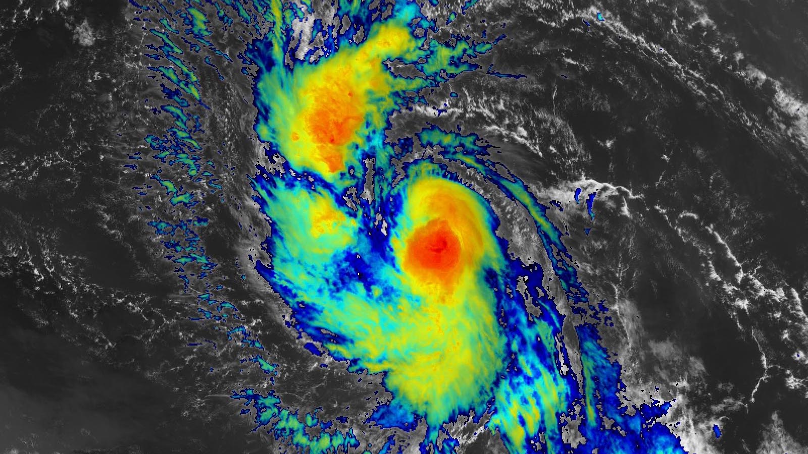
At 11 a.m. EDT Wednesday, Lee was located about 1200 miles east of the northern Leeward Islands, moving west-northwest at 14 mph with top sustained winds of 70 mph and a central pressure of 994 mb. Satellite images early Wednesday afternoon showed a large system with improving organization, with low-level spiral bands developing and heavy thunderstorm activity growing more concentrated. Given the steadily improving appearance of Lee, it is likely to be a hurricane later on Wednesday.
Track forecast for Lee
Lee is expected to move west-northwest at a steady forward speed of 13 – 16 mph this week, driven by the clockwise circulation around the Azores-Bermuda High to the north. On this track, the system should pass a few hundred miles to the northeast of the northernmost Leeward Islands Saturday and Sunday. This would be close enough for the outer spiral bands to bring heavy rains and gusty winds to these islands, but the damaging winds of the eyewall would stay out to sea. However, since these northernmost islands are just south of the edge of the NHC cone of uncertainty, more substantial impacts are still a possibility. NHC is forecasting about a 20-30% chance of tropical storm-force winds in these islands, and a 0-5% chance of hurricane-force winds.
By Tuesday, a trough of low pressure moving off the eastern coast of North America will likely tug Lee to the north-northwest. While this turn is currently predicted to keep the core of Lee away from the southeastern Bahamas and Turks and Caicos Islands, these islands may experience heavy rains from the outer spiral bands of Lee, and should be alert to the potential for Lee to come closer than currently forecasted.
After turning to the northwest and then north next week, Lee is expected to make its closest approach to Bermuda around September 14. However, long-range forecast skill so far in the future is poor, and the threat to Bermuda is unclear. An eventual landfall in the Canadian Maritime provinces or the U.S. East Coast north of Florida is possible after Lee passes Bermuda, as is a recurvature to the northeast, out to sea. One impact seems guaranteed, though: Lee will bring a prolonged period of high surf and dangerous rip currents along the entire eastern seaboard late next week, and to the northern shores of the islands of the northeastern Caribbean beginning early next week.

Intensity forecast for Lee
Lee currently has favorable conditions for intensification, with warm waters of 29 degrees Celsius (84°F), moderate wind shear of 10-15 knots, and a reasonably moist atmosphere (a mid-level relative humidity of 60-65%). Conditions will grow more favorable through the weekend along Lee’s path, as the system encounters lower wind shear and steadily warming waters (including an increase in the total heat content of the ocean waters). The intensity models are in unanimous agreement that Lee will become a major hurricane by week’s end, and the National Hurricane Center continues to make aggressive intensity forecasts, calling for a Category 4 hurricane with 150 mph winds Saturday and Sunday.
The 12Z Wednesday run of the SHIPS model gave Lee a 33% chance of rapidly intensifying by 35 mph over the next 24 hours, and a 29% chance of intensifying by 75 mph over the next three days. Based on the atmospheric and oceanic conditions expected Friday through Sunday, the model predicted that Lee’s maximum potential intensity would be a category 5 hurricane with 190-195 mph winds. The 6Z Wednesday run of the HAFS-B model put Lee’s intensity not far below that, predicting Lee would peak with 180 mph winds and a 901 mb central pressure early Sunday morning. The 6Z Wednesday runs of the HWRF, HMON, and HAFS-A models predicted Lee would peak with 145 mph, 160 mph, and 175 mph winds, respectively.
Once Lee turns north-northwest over the waters between the Bahamas and Bermuda next week, conditions for intensification will grow less favorable, as the storm will have to cross the cool water wakes left behind by Hurricane Franklin and Hurricane Idalia. It is uncertain what wind shear might be so far into the future.
Invest 96L bringing heavy rains to the Cabo Verde islands
A tropical wave designated 96L was centered a few hundred miles southeast of the Cabo Verde islands on Wednesday afternoon. Satellite images showed that 96L had a respectable amount of heavy thunderstorm activity and spin. This wave was headed west-northwest at 10-15 mph, and will bring heavy rains and gusty winds to the Cabo Verde islands on Wednesday and Thursday. After 96L moves past these islands, no other land areas lie in its projected path, which will take it into the remote central Atlantic. In their 8 a.m. EDT Wednesday Tropical Weather Outlook, NHC gave 96L two-day and seven-day odds of formation of 30% and 60%, respectively. The next name on the Atlantic list of storms is Margot.
Ex-Franklin has low odds of regeneration
The remains of Hurricane Franklin, which were swirling a few hundred miles east-northeast of the Azores on Wednesday afternoon, are expected to move north to northeast into cooler waters late this week, giving a brief window of time for a tropical or subtropical storm to form. In their 8 a.m. EDT Wednesday Tropical Weather Outlook, NHC gave ex-Franklin two-day and seven-day odds of formation of 10%.
Next tropical wave
The GFS and European model are showing development could occur by the middle of next week in the central tropical Atlantic of a tropical wave predicted to move off the coast of Africa this weekend. This wave is not yet being highlighted by NHC in their Tropical Weather Outlook. This wave is predicted to come off of Africa at a low enough latitude so that it might be a long-range threat to the Caribbean.
Website visitors can comment on “Eye on the Storm” posts (see comments policy below). Sign up to receive notices of new postings here.
Source link