Hurricane Hunters made their first flights into Tropical Storm Idalia on Sunday, launching what will be one of the largest sequences of flights and weather-balloon launches carried out in years to monitor a potential Atlantic hurricane. Tropical Depression 10 was upgraded to Tropical Storm Idalia at 11:15 a.m. EDT Sunday after a NOAA reconnaissance flight found that surface winds had increased to 40 mph. Tropical Storm Warnings were in effect for far western Cuba and the northeast Yucatan Peninsula of Mexico. Storm surge and wind watches will likely be issued later on Sunday for parts of the Florida West Coast, and additional watches and warnings for Florida will follow if Idalia develops as expected.
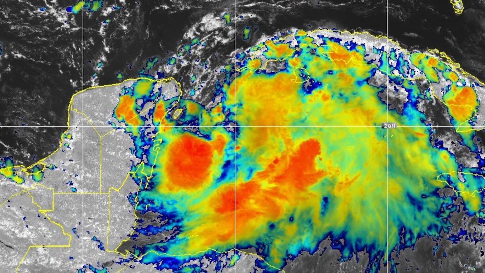
Satellite imagery and radar loops early Sunday afternoon depicted showers and thunderstorms (convection) erupting near a distinct low-level center spinning about 80 miles east-southeast of Cozumel, Mexico. A much larger field of convection extended well east of Idalia’s center across the northwest Caribbean. Idalia’s overall circulation was weak but expansive, already covering a large part of the Gulf of Mexico and western Caribbean. Outflow from Idalia was gradually improving at upper levels, especially east of the center.
The reconnaissance plan issued on Saturday a included a flurry of NOAA and Air Force flights that began on Sunday to monitor Idalia as well as potent Hurricane Franklin, which will remain well east of the United States (see below). The biggest question marks on Sunday were how large and strong Idalia will be at landfall and where exactly on the Florida Gulf Coast it will arrive.
Track forecast for Idalia
From late Saturday into Sunday, Idalia’s center moved little, carving out a tight loop just east of the Yucatan Peninsula within the broader circulation. Steering currents around Idalia should remain weak for a while longer, but by Monday an upper-level low will be dipping from the Central Gulf Coast into the northeast Gulf, which should start tugging Idalia northward. A larger, stronger upper low now in Canada will dive into the eastern U.S. by Tuesday, accelerating Idalia north-northeastward into the Florida Gulf Coast by late Tuesday or Wednesday.
Track forecasts along the west coast of Florida are notoriously challenging because tropical cyclones are typically approaching from the southwest, i.e., at an oblique angle. That means only a slight nudge in trajectory to the right or left can change the landfall location by 50 or 100 miles. As of Sunday morning, forecast models were in general agreement on a landfall Tuesday night or Wednesday morning somewhere between the central Florida Panhandle and the Tampa Bay area. The bulk of ensemble members from the GFS and European models, as well as most of the 12Z dynamical models, depicted a landfall in the Big Bend area, roughly between Apalachicola and Crystal River. Although this general track would make sense given the steering currents at hand, the outlying ensemble members still show a wide range of possibilities (see Figure 1 below), and it is too soon to take any precise landfall forecast as gospel.

Starting late Sunday, NOAA G-4 missions will sample the large-scale environment around Idalia, gathering data that will help forecast models refine their prognoses starting with the late-Sunday model runs (0Z Monday). NOAA will also be launching extra weather balloons (radiosondes) along the eastern Gulf of Mexico coastline, further enhancing the available data. For now, it would be wise to be remain on alert for a broad range of possible landfall locations along Florida’s Gulf Coast, at least until the more data-rich model runs are in hand starting late Sunday night.
After landfall, Idalia should be carried northeastward near or along the Southeast U.S. coast on Wednesday and Thursday before it angles eastward away from the coast around Friday.
Intensity forecast for Idalia
Idalia will remain a weak tropical storm until it manages to consolidate convection atop and near its low-level circulation. The sooner this happens, the more potential Idalia will have to intensify well before reaching Florida. The very warm waters of the Northwest Caribbean (sea surface temperatures around 30 degrees Celsius or 86 degrees Fahrenheit) will provide ample fuel. These warm waters extend to great depths, providing high oceanic heat content and reducing the chance that Idalia’s slow movement will cause major upwelling of cooler water. The eastern Gulf of Mexico is even warmer, with widespread sea surface temperatures of 31°C (88°F) extending to well below 100 feet. These record-warm conditions will be exceptionally dangerous “rocket fuel”, assuming that Idalia reaches the eastern Gulf as a well-organized system.
Idalia’s large circulation entrained some pockets of dry air from the northern and western Gulf of Mexico and from the Yucatan Peninsula this weekend, helping lead to the storm’s broad but scattered convective pattern. Overall, though, atmospheric conditions are quite favorable for Idalia to intensify. A fairly moist mid-level atmosphere (65-70 percent) are expected to prevail through at least Monday night. Moderate to strong wind shear (15-20 knots) was keeping most of Idalia’s convection east of the center, as shown in the top image, while helping to enlarge the storm’s overall envelope. The shear should gradually abate by Monday night or Tuesday, when we should pay particular attention to the chance of rapid strengthening.
The National Hurricane Center predicted at 11 a.m. EDT Sunday that Idalia would become a hurricane by midday Tuesday and peak at category 1 strength (90 mph sustained winds), roughly in line with the most recent dynamical model guidance available at that point. The subsequent 12Z Sunday runs of the short-range HMON, HWRF, HAFS-A, and HAFS-B models were considerably stronger, agreeing on the scenario of Idalia arriving in or near the Florida Big Bend as a major category 3 hurricane on Tuesday night. These short-range intensity models will be especially important to monitor once they can draw on the enhanced large-scale reconnaissance and radiosonde data that will be available from Sunday night onward.
Wind shear will increase sharply by late Tuesday as Idalia is pulled into the eastern Gulf, but the storm will be moving along with that shear, which will help limit its effect. In fact, the shear could end up providing a powerful outflow jet at upper levels, as seen in several recent eastern-Gulf hurricanes that intensified sharply before landfall. There have been far too many cases in the past of western Caribbean disturbances entering the Gulf which ended up far exceeding model expectations. This includes Hurricane Michael from 2018, which also originated near the Yucatan Peninsula. Just 72 hours ahead of its Florida Panhandle landfall, while it was still a tropical depression near the Yucatan, Michael was predicted to peak at category 1 strength, whereas it ended up striking as a category 5. We should not be surprised if Idalia makes landfall as a powerful, rapidly intensifying hurricane.
Florida Gulf Coast storm surge
Idalia will pose a significant storm-surge threat over parts of the Florida Gulf Coast, mainly near and to the right of where the center makes landfall. All else being equal, a larger hurricane will deliver a greater storm surge, so the large circulation already associated with Idalia could pose an enhanced storm surge assuming that it maintains its size.
The Florida Gulf Coast has a wide continental shelf with shallow waters, providing an ideal situation for high storm surges to build up. Furthermore, because of the unique bathymetry of the region, hurricanes tracking from south to north off the west coast of Florida can create a “shelf wave” of higher surge that can propagate northwards along the coast, inundating the coast over 100 miles to the east of where the hurricane tracks. Even a category 1 hurricane can deliver a storm surge over seven feet high to the Big Bend area – as occurred during Hurricane Hermine of 2016.

Hurricane Hermine of 2016
The most recent hurricane to hit the Big Bend region of Florida was Hurricane Hermine, which hit just east of St. Marks as a Category 1 hurricane with 80 mph winds on September 2, 2016. Hermine broke a 10-year hurricane landfall drought for Florida that had extended back to October 2005 (Hurricane Wilma). Hermine killed one person and did $550 million in damage (2016 dollars), mostly from storm surge and high winds.
Hermine’s highest measured storm surge was 7.5 ft above normal tide levels at Cedar Key, which lay about 100 miles to the east of Hermine’s path. Hermine’s storm tide (the combined effect of the surge and tide) was 5.98 feet above the high tide mark (Mean Higher High Water, or MHHW), setting an all-time record there – an impressive feat for a site that has records going back to 1914. Hermine produced maximum inundation levels of four to seven feet above MHHW to the east of the landfall location, along the immediate coasts of Jefferson, Taylor, Dixie, and Levy Counties, and two to four feet above ground level south of Cedar Key to Ft. Myers, including Tampa Bay. Inundation levels of two to four feet above ground level also occurred west of Hermine’s landfall point from St. Marks westward to Cape San Blas (Wakulla, Franklin, and Gulf Counties). Hermine produced heavy rainfall across much of western and northern Florida, extending northward across coastal sections of Georgia, South Carolina, and North Carolina, with a maximum of 22.36 inches near Tarpon Springs, Florida. Flooding occurred on several rivers in northern Florida, although only the Anclote River reached major flood stage.
If Idalia becomes as strong and large as models and current conditions are implying it could, there will be a risk of significant storm surge as far south as the Tampa-St. Petersburg area even if Idalia makes landfall well to the north. Residents should pay close attention to NHC storm surge watches and warnings as well as hurricane watches and warnings. In 2022’s Hurricane Ian, 6 to 12 feet of destructive surge extended all the way to the Naples area, which was placed in a storm surge warning 24 hours before it was in a hurricane warning.
High/low tide this week
The difference between low tide and high tide at Cedar Key, Florida is relatively large – about four feet – and there are two low tides and two high tides per day, so the precise timing of the storm surge with respect to the tide matters a great deal. The highest high tide is about 1.5 feet higher than the lower of the two high tides. The highest high tide during the approach of Idalia is at 1:45 p.m. EDT Wednesday; the lower high tide is at 2:35 a.m. EDT Wednesday. Low tide is at 7:50 a.m. Wednesday. Unfortunately, this month’s full moon occurs Wednesday night, so the tides that day are among the highest of the month.
Flooding threat from Idalia
Idalia’s expansive circulation will bring heavy rains to a large part of the Florida Peninsula. Widespread 1-inch to 4-inch totals can be expected statewide, with a corridor of 4-12” rains (and even higher amounts in isolated areas) along Idalia’s eventual track from its landfall location northeastward to the Carolinas. Substantial flooding close to Idalia’s track can be expected, and outer rainbands may also produce localized flash flooding. The central Gulf Coast of Florida, including Tampa-St. Petersburg, is in extreme to exceptional drought, so at least some rain would be beneficial there.
Franklin becomes a powerhouse well east of the United States
Hurricane Franklin vaulted to category 2 strength early Sunday east of the Bahamas, and it is now predicted to peak as a category 4 storm by Monday night. The only populated area at risk of direct impacts from Franklin is Bermuda. The island is predicted to be on Franklin’s more dangerous right-hand side on Wednesday as the hurricane passes about 100-150 miles to the northwest, close enough to bring strong winds and squalls. Probabilistic guidance showed a 70 percent chance of Bermuda receiving tropical-storm strength winds on Tuesday and Wednesday. Ensemble models depict a slight risk of an eastward turn around Tuesday that could bring Franklin closer to the island, so residents should monitor the forecast closely. The only other area in the Atlantic of note is a tropical wave that could slowly develop after it moves off the coast of Africa this week.
Source link