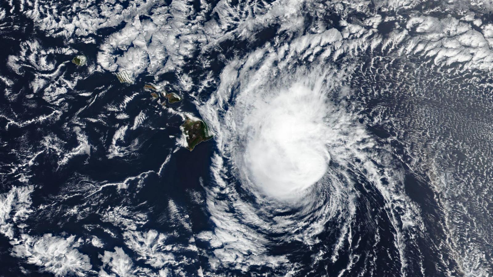
Tropical storm warnings were flying for Hawai’i’s Big Island and Maui on Wednesday morning as Tropical Storm Calvin’s center passed just south of the Big Island. At 11 a.m. EDT Wednesday, Calvin was located about 100 miles southwest of the southern tip of the Big Island, moving west at 20 mph. Calvin’s top sustained winds had weakened to 45 mph, down from 50 mph six hours previously.
Widespread 24-hour rainfall amounts of 2-6 inches had fallen on the northeast side of the Big Island as of 10 a.m. EDT Wednesday, and Calvin is predicted to bring the Big Island storm total rainfall amounts of 4-8 inches, with isolated amounts up to 10 inches. Lesser rains were affecting Maui, where 1-3 of rain at higher elevations had fallen. Flash flooding is the primary hazard from Calvin for Hawai’i.
Calvin’s impact on Hawai’i will be relatively short-lived. Wind shear and dry air are expected to reduce the storm to a tropical depression by Thursday morning, and Calvin will likely dissipate by Thursday evening.

Calvin is the third tropical cyclone to affect the U.S. and its territories so far in 2023. The others:
- Typhoon Mawar passed along the northern coast of Guam on May 24 as it traversed the Rota Channel as a category 4 storm with 140 mph winds. Mawar killed two people on Guam, and according to Gallagher Re, total damage from the typhoon was $530 million, with most of that occurring on Guam (lesser damages occurred in the Philippines, Taiwan, and Japan).
- On June 2, Tropical Storm Arlene peaked with 40 mph winds in the Gulf of Mexico, then decayed to a post-tropical cyclone the next day. Arlene brought heavy rains of 2-6 inches to Florida, which helped alleviate drought conditions. No damage or casualties were reported.
Hawai’i hurricane history
Simply making landfall in Hawai’i is no small achievement for a tropical cyclone, and ultimately Calvin was not able to find such a small target in a big ocean. Only five named systems at tropical storm strength or higher have made landfall in Hawai’i:
- Hurricane Dot made landfall on Kauai as a Category 1 hurricane on August 6, 1959, about two weeks before Hawai’i gained statehood. Dot caused 6 indirect deaths and $6 million in damage (1959 dollars).
- Hurricane Iniki made landfall in Kauai as a Category 4 hurricane on September 11, 1992, killing 6 and causing $1.8 billion in damage (1992 dollars.)
- Tropical Storm Iselle, which, like Darby, made landfall along the southeast shore of the Big Island, arrived as a 60-mph tropical storm on August 8, 2014. Iselle killed one person and did $79 million in damage (2014 dollars).
- Tropical Storm Darby made landfall along the southeast shore of Hawai’i’s Big Island on July 23, 2016, with sustained winds of 40 mph. Damage was minimal and there were no deaths.
- Tropical Storm Olivia made landfall on the north shore of both Maui and Lanai on September 12, 2018 with sustained winds of 45 mph. Olivia was blamed for $25 million in damage (2018 dollars).
In addition, Post-Tropical Cyclone Linda hit on Molokai on August 23, 2021 with sustained winds of 40 mph. There were no reports of casualties or damage from Linda.
As defined by NHC, landfall requires the center of a tropical cyclone to pass over land. Other hurricanes and tropical storms, most notably Lane in 2018 ($250 million in damage) and Iwa in 1992 ($312 million in damage), have had significant impacts without making landfall. It’s worth noting that five of the six landfalls now on the books for Hawai’i (counting the two from Olivia) have occurred in just the last ten years. A 2016 modeling study found that we could expect to see a significant increase in hurricanes near Hawai’i in coming decades due to climate change; see also Jeff Masters’ August 2014 post, Climate Change May Increase the Number of Hawaiian Hurricanes.
Tropical Storm Don continues to wander in the central Atlantic
After making the transition from a subtropical depression to a tropical depression at 11 a.m. Monday morning, Don is now a tropical storm in the central Atlantic. At 11 a.m. EDT Wednesday, Don had top sustained winds of 40 mph, and was headed west-southwest at 5 mph. Don is in the process of a completing a clockwise 360-degree loop over the open ocean, and is expected to become a post-tropical cyclone on Monday aver the cold Atlantic waters east of Newfoundland, Canada. Don is not a threat to any land areas.
A new tropical wave to watch emerged from the coast of Africa Wednesday, and was located a few hundred miles south of the Cabo Verde Islands on Wednesday morning. This wave will have formidable barriers to development – dry air to the north and at least moderate wind shear because of the system’s rapid forward motion – as it speeds west at 15-20 mph over the next week. The wave has relatively poor model support for development, and in their 8 a.m. EDT Tropical Weather Outlook, the National Hurricane Center gave the wave 2-day and 7-day odds of development of 0% and 20%, respectively.
Asia on the lookout for disturbance 98W
The most significant tropical cyclone threat next week is likely to come from disturbance 98W, located on Wednesday morning in the western Pacific about 500 miles east of the Philippines. Model forecasts have consistently predicted that this disturbance will develop into a typhoon by early next week, with a potential threat to the Philippines, Taiwan, and/or China.
Bob Henson contributed to this post.
Website visitors can comment on “Eye on the Storm” posts (see comments policy below). Sign up to receive notices of new postings here.
Source link