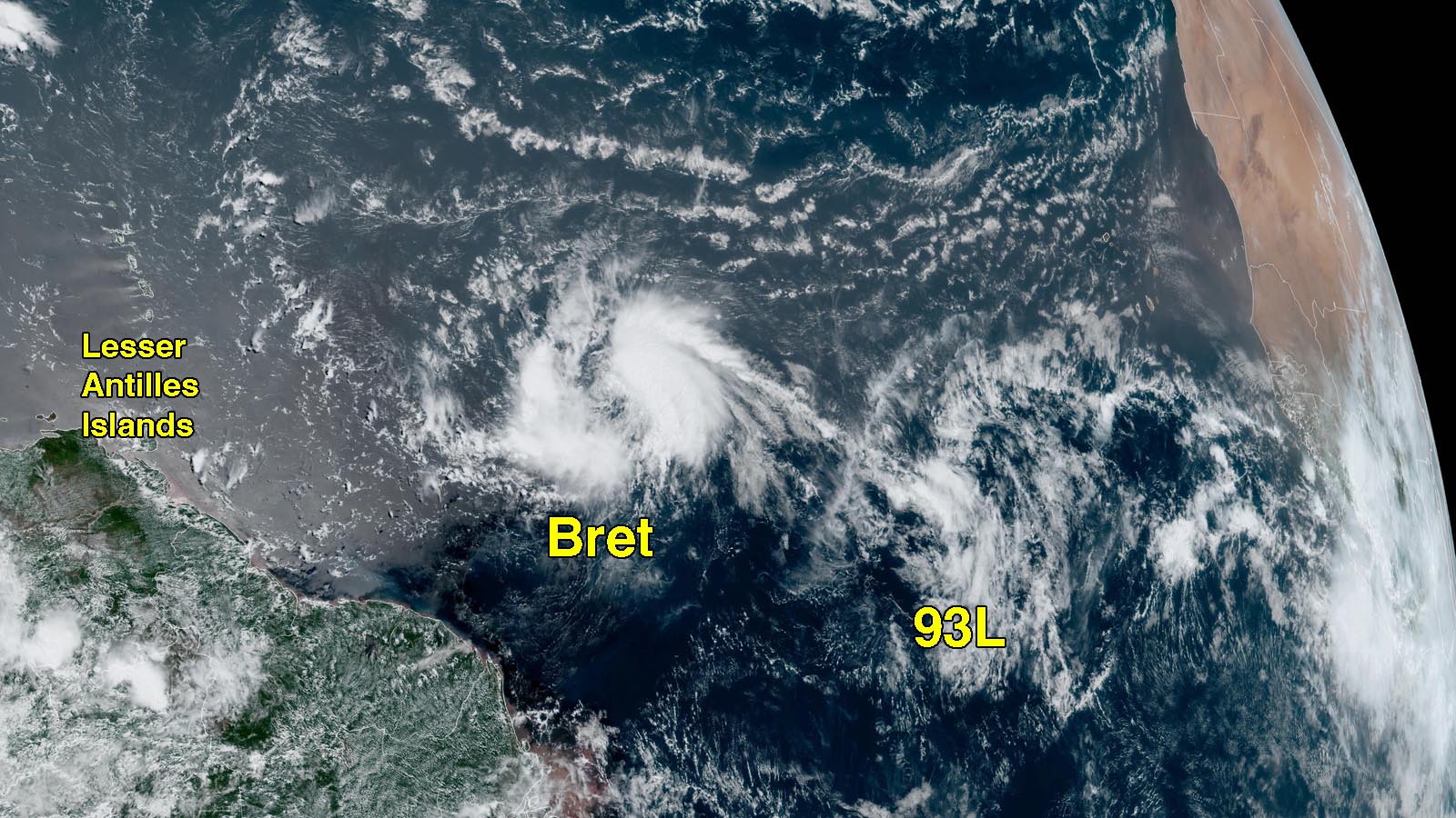
Tropical Storm Bret has encountered significant wind shear and has not intensified as much as predicted, and is no longer expected to be a hurricane when it passes through the Lesser Antilles Islands on Thursday and Friday. At 11 a.m. EDT Tuesday, Bret was headed west at 21 mph with a central pressure of 1008 mb and top sustained winds of 40 mph. This rapid forward speed was likely partially responsible for the wind shear affecting Bret and the storm’s disheveled appearance.
Satellite images on Tuesday morning showed the classic signs of a tropical cyclone struggling with wind shear: a low-level circulation mostly exposed to view, and most of the storm’s heavy thunderstorms displaced to one side. In this case, most of Bret’s heavy thunderstorms were on the east side of the circulation center, although there is some convection to the west.
Track forecast for Bret
The computer models have come into better agreement on Bret’s track, with a mostly westward path taking the storm through the Lesser Antilles on Thursday and Friday, then into the eastern Caribbean. The European model and its ensembles predicted a faster forward speed, with Bret moving through the islands on Thursday afternoon. The GFS model had a slower-moving storm that would not arrive in the islands until Friday morning.
A turn more to the west-northwest as the system approaches the Lesser Antilles is no longer expected, since this turn would only occur with a stronger storm that would “feel” steering currents pulling it more to the west-northwest. With the intensity forecasts now trending down, this turn to the west-northwest is looking unlikely.


Intensity forecast for Bret
Conditions are expected to be generally favorable for development for Bret through Wednesday night, with moderate wind shear, a moderately moist atmosphere, and record-warm sea surface temperatures for late June near 28-29 degrees Celsius (82-84°F). However, as the system approaches the Lesser Antilles, an upper-level trough will bring higher wind shear, and the storm will encounter dryer air. These factors should cause weakening. The intensity models have more agreement, showing Bret will likely be a tropical storm when it passes through the Lesser Antilles. The HWRF model was a significant outlier, predicting a major hurricane, but the model has a known high bias in this region (see tweet by Andy Hazelton below).

Once Bret moves into the Eastern Caribbean, high wind shear and dry air will continue to affect the storm – as is so often the case in this “hurricane graveyard” area during June and July – and none of the models show Bret surviving very long. At this time, it does not appear that Bret poses a long-range threat to the western Caribbean or the U.S.
The first hurricane hunter mission into Bret is scheduled for Wednesday afternoon.
Bret is the third Atlantic storm of the year, following the formation of Tropical Storm Arlene on June 2 and an unnamed subtropical storm on January 16. Bret formed at 5 p.m. EDT June 19 at longitude 42.2 degrees west, which is the farthest east in the tropical Atlantic that any named storm has developed so early in hurricane season. Bret’s formation date comes well before the typical formation date of the season’s third storm of Aug. 3. The record-earliest formation date of the season’s third named storm was June 2, 2020, when Tropical Storm Cristobal formed. That year had a record 30 named storms and holds 26 of the 30 earliest formation date records.
Tropical wave 93L off the coast of Africa expected to develop
A tropical wave that emerged from the coast of Africa over the weekend was located a few hundred miles southwest of the Cabo Verde Islands on Tuesday morning. This wave, designated 93L by the National Hurricane Center, was headed west at 10-15 mph. Satellite images on Tuesday morning showed that 93L did not yet have a well-defined surface circulation, and its heavy thunderstorm activity was relatively sparse. Conditions are expected to be favorable for development over the next three days, though, with moderate wind shear of 10-20 knots, a moist atmosphere, and record-warm sea surface temperatures near 28 degrees Celsius (82°F).
This system has strong support for development by late this week from the GFS and European models. Since the centers of Bret and 93L are only about 700 miles (1100 km) apart, they may feel some influence from the Fujiwhara effect, which makes closely spaced tropical cyclones tend to rotate around each other. In this case, the Fujiwhara effect would tend to nudge Bret a bit further south and 93L a bit further north than the larger-scale steering currents would otherwise dictate.
In their 8 a.m. EDT Tuesday Tropical Weather Outlook, the National Hurricane Center gave 93L 2-day and 7-day odds of development of 70% and 80%, respectively. The next name on the Atlantic list of storms is Cindy. The typical formation date of the season’s fourth storm is Aug. 15. The record-earliest formation date of the season’s fourth named storm is Jun. 20, 2016, when Tropical Storm Danielle formed.
Bob Henson contributed to this post.
Website visitors can comment on “Eye on the Storm” posts (see comments policy below). Sign up to receive notices of new postings here.
Source link


