For the first time on record in June, we have two tropical cyclones prowling the Atlantic east of the Caribbean at the same time. On Thursday, June 22, Tropical Storm Bret was approaching the central islands of the Lesser Antilles. Meanwhile, newborn Tropical Depression Four – predicted to become Tropical Storm Cindy – was gathering strength in the central tropical Atlantic.

As of 11 a.m. EDT Thursday, Bret was located about 130 miles east-northeast of Barbados and about 220 miles east of St. Lucia. The tropical storm was continuing on a steady course just north of due west at about 14 mph, and the National Hurricane Center (NHC) predicted little change in Bret’s track before it reaches the islands. On this course, Bret should pass near or over St. Lucia or Martinique on Thursday night.
Martinique would likely experience the strongest winds from Bret, as the storm’s westward motion would put the highest winds on its north side. Gusts of 50-70 mph are possible just north of Bret’s track. Tropical storm force winds extend out up to 115 miles to the north of Bret’s center, so gale-force squalls could easily extend north as far as Guadeloupe. The main threat from Bret will be spells of torrential rain and the potential for flash flooding from Bret’s envelope of showers and thunderstorms (convection). Rainfall totals of 3-6 inches could extend from St. Vincent and the Grenadines to Guadeloupe, and localized amounts of 10 inches are possible.
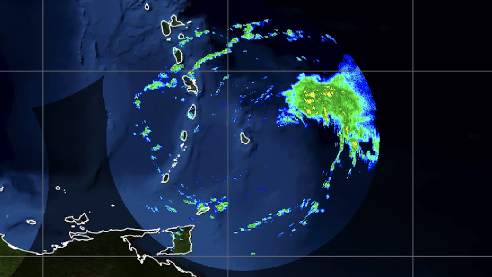
Reconaissance flights showed that Bret’s top winds had strengthened from Wednesday to Thursday. However, Bret remained a complex, far-from-textbook system, with convection often displaced well away from Bret’s center and pulsating in erratic fashion.
At one point, satellite images on Thursday morning showed a fanning cirrus pattern on Bret’s western side, indicative of outflow developing at upper levels that could help Bret to strengthen. However, it also appeared that westerly wind shear was still present in between that level and the surface, pushing dry air into Bret’s west side. As a result, most of Bret’s convection was arcing around it east side, as shown in the image at top. With these issues, Bret is not expected to vault to hurricane strength before reaching the islands.

Once it moves into the Caribbean, Bret will face an increasingly hostile environment of wind shear that’s expected to weaken the storm into a tropical depression by this weekend, and perhaps force it to dissipate shortly thereafter, as predicted by NHC. As seen in Figure 1, some model ensemble members depict a weakened Bret hanging on for several more days and perhaps reaching the coast of Central America as it crosses the warm, supportive waters of the Caribbean. The chance of any major re-intensification appears remote at present.
Tropical Depression Four expected to become Tropical Storm Cindy
As Bret begins to weaken in the “hurricane graveyard” of the eastern Caribbean, all eyes will be turning back to the Main Development Region, the open expanse of tropical Atlantic waters between the Lesser Antilles and Africa. In the middle of that region is a system designated Tropical Depression 4 on Thursday morning. As of 11 a.m. EDT, TD 4 was located nearly 1300 miles east of the islands, moving west-northwest at 15 mph. The depression has a distinct low-level circulation evident on satellite, but most convection is being shunted west of TD 4’s center by easterly wind shear.
As TD 4 gradually accelerates to the west-northwest, it should help lessen the easterly shear effect and give the system a chance to organize atop the unusually warm waters (sea surface temperatures of 27-28 degrees Celsius or 81-82 degrees Fahrenheit).
There’s a solid consensus among forecast models (see Figure 2 below) that TD 4 will strengthen into Tropical Storm Cindy, as predicted by NHC to happen as soon as Thursday night. If so, it’ll be history in the making. Across NOAA hurricane records that go back to 1851, only a handful of tropical cyclones have formed in the Main Development Region during June, and no June has spawned two tropical cyclones there. Sea surface temperatures over the region are typically too cool to support tropical development until later in the summer, and it’s usually too early for the sequence of easterly waves streaming from Africa into the region to get rolling. But the surface waters have been record-warm this year, and a robust wave train has set up well ahead of schedule.

Assuming it evolves into Cindy as expected, TD 4 should feel a northward tug from steering flow around a large low across the western North Atlantic, thus causing it to angle more toward the northwest over time and most likely miss the Caribbean Islands. It could survive as a tropical storm or tropical depression for most or all of the next week, though, which would be an unusual occurrence in June.
The Northeast Pacific may get its first tropical cyclone after a much-delayed start
In its Tropical Weather Outlook for the Northeast Pacific on Thursday morning, NHC gave 70 percent odds that at least a tropical depression will form well off the southwest Mexican coast, most likely early next week.
So far in 2023, there have been no tropical cyclones whatsoever in the Northeast Pacific. If a tropical storm does not form there through Monday, June 26, it will set a new record for the latest start to activity in the basin in satellite-based records going back to 1970.
Jeff Masters contributed to this post. Website visitors can comment on “Eye on the Storm” posts (see comments policy below). Sign up to receive notices of new postings here.
Source link