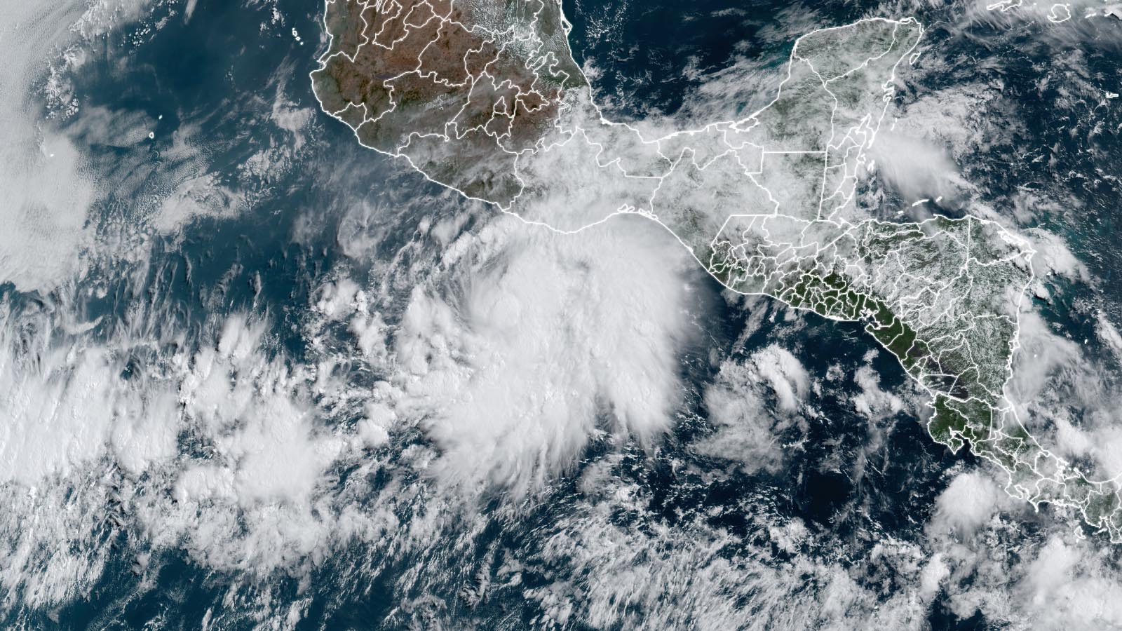
Hurricane watches are posted for portions of the southern coast of Mexico as the first named storm of the 2022 eastern Pacific hurricane season, Tropical Storm Agatha, gathers strength in the warm waters about 200 miles offshore. Agatha formed at 5 a.m. EDT Saturday, May 28, and it is poised to intensify into a rare early-season category 2 hurricane before landfall.
At 11 a.m. EDT Saturday, Agatha was located about 215 miles southwest of Puerto Angel, Mexico, moving west-northwest at 5 mph with top sustained winds of 45 mph and a central pressure of 1002 mb. Agatha was benefiting from very favorable conditions for intensification, with very warm waters of 30-31 degrees Celsius (86-88°F), light wind shear of 5-10 knots, and a moist atmosphere with a mid-level relative humidity of 75%. These favorable conditions are predicted to persist through landfall. Steering currents favor a track bending to the northeast Sunday and Monday, with landfall in southeastern Mexico occurring Monday afternoon or evening. Destructive winds, a large storm surge, and torrential rains of 10-16 inches will all present significant hazards for Mexico. The first hurricane hunter mission into Agatha is scheduled for Sunday afternoon, if an airplane is available.


Agatha’s remnants may bring year’s first Atlantic named storm
Agatha is expected to dissipate over the high terrain of Mexico about a day after making landfall, but remnants of the storm will be caught up in a southwesterly flow that will bring the storm’s moisture and spin over the southern Gulf of Mexico and western Caribbean on Wednesday and Thursday. A number of the ensemble members of the GFS and European models show Agatha regenerating into the Atlantic’s first named 2022 storm in the Atlantic by the middle of the week.
If Agatha were able to maintain a well-defined circulation and reform over the Gulf of Mexico, like the 0Z Saturday run of the European model indicated is possible, it would likely retain the name Agatha. Otherwise, any storm that formed from Agatha’s remnants in the Atlantic would be named Alex. The 6Z Saturday run of the GFS model favored the latter scenario, with a potential Tropical Storm Alex forming in the western Caribbean near central Cuba on Thursday. In its 8 a.m. EDT Saturday Tropical Weather Outlook, the National Hurricane Center gave five-day odds of tropical cyclone formation over the southern Gulf of Mexico of 20% to Agatha (or its remnants). Preliminary forecasts suggest that any storm that does form in the Gulf or western Caribbean would suffer high wind shear that would keep it weak, making it primarily a heavy rain threat.


Landfalling eastern Pacific hurricanes are rare in May
Hurricanes are uncommon in May in the eastern Pacific, with 14 on record over the 51-year period 1971-2021 (Figure 2). May landfalling hurricanes are very rare in the eastern Pacific. NOAA’s hurricane history database lists only two: a previous incarnation of Hurricane Agatha on May 24, 1971 (85 mph winds at landfall), and Hurricane Barbara on May 29, 2013 (80 mph winds at landfall). The latest NHC forecast has the 2022 version of Hurricane Agatha making landfall as a category 2 storm with 100 mph winds, which would make it the strongest landfalling Pacific hurricane on record so early in the year.
Major hurricanes are also rare in the eastern Pacific during May, with only five recorded and none making landfall:
Andres, May 31, 2015, 125 mph winds (Cat 3);
Amanda, May 25, 2014, 155 mph winds (Cat 4);
Bud, May 25, 2012, 115 mph winds (Cat 3);
Alma, May 24, 2002, 115 mph winds (Cat 3); and
Adolph, May 29, 2001, 145 mph winds (Cat 4)


No evidence Eastern Pacific hurricane season is getting longer
Agatha’s formation date of May 28 comes nearly two weeks earlier than the average June 10 formation date of the eastern Pacific’s first named storm of the season (for the period 1991-2020). And last year, the basin experienced it earliest-ever first named storm, Tropical Storm Andres, on May 9. So, is the season getting longer?
One might expect that hurricane season will start earlier and end later in coming decades as warming of the oceans allows more storms to form when ocean temperatures are marginally warm for tropical cyclone formation. However, hurricane genesis also requires low wind shear, high levels of moisture at mid-levels of the atmosphere, and something to get the low-level atmosphere rotating. In some ocean basins, climate change may inhibit early-season genesis events by decreasing these other factors needed for a hurricane to get started. Looking at the longer-term statistics for the eastern Pacific, there is no evidence that hurricane season is starting earlier (Figure 3).
No research has been published thus far showing a change in the length of the Eastern Pacific hurricane season. A 2015 study of how climate change might be expected to influence season length in climate models, led by MIT’s John Dwyer, yielded mixed results for the Eastern Pacific, depending upon which model was used to simulate hurricane activity. Most models, but not all, projected an increase in the length of the Eastern Pacific hurricane season in a future warmer climate.
The Atlantic hurricane season does appear to be getting longer in the region south of 30°N and east of 75°W, according to a 2008 paper in Geophysical Research Letters published by Dr. James Kossin of the University of Wisconsin and titled, “Is the North Atlantic hurricane season getting longer?” A 2016 analysis by Dr. Ryan Truchelut of WeatherTiger also supported this idea. However, Juliana Karloski and Clark Evans of the University of Wisconsin-Milwaukee found no trend in tropical cyclone formation dates when looking at the entire Atlantic for the period 1979–2014.
NOAA predicts below-average season in the central and eastern Pacific
In its May 24 seasonal forecast, NOAA predicted a below-average 2022 hurricane season in both the eastern Pacific (for storms affecting Mexico) and the central Pacific (for storms affecting Hawaii). NOAA in its eastern Pacific outlook called for a 70% probability of 10-17 named storms, with 4-8 expected to become hurricanes, including 0-3 major hurricanes. An ACE of 45% – 100% of the median was also predicted. Using the midpoint of these ranges, NOAA called for 13.5 named storms, 6 hurricanes, and 1.5 major hurricanes, falling below the 1991-2020 averages of 15 named storms, eight hurricanes, four major hurricanes.
The central Pacific outlook called for a 70% probability of 2-4 tropical cyclones (which includes tropical depressions, tropical storms, and hurricanes). A near-average season there has 4-5 tropical cyclones. La Niña conditions typically lead to relatively quiet hurricane seasons in both the eastern and central Pacific as a result of cooler-than-average ocean temperatures and higher wind shear.
Below-average activity in eastern Pacific in 2021
As is often the case when the Atlantic has an active hurricane season, tropical cyclone activity in the eastern Pacific was below average in 2021, with 19 named storms, eight hurricanes, two major hurricanes, and an ACE index of 94, which is 71% of average.
However, five of 2021’s eastern Pacific named storms hit Mexico, and a sixth, Enrique, did $50 million in damage. The five eastern Pacific named storm landfalls are the most in the nation since 2018, when six named storms hit. A summary of the 2021 Pacific named storms to do damage in Mexico:
- Hurricane Rick made landfall as a category 2 storm with 105 mph winds in the state of Guerrero, Mexico, on October 25; damage estimates are in the tens of millions.
- Hurricane Pamela made landfall as a category 1 storm with 75 mph winds 40 miles northwest of Mazatlán, Mexico, on October 13, killing two; damage estimates are in the tens of millions. Pamela’s remnants swept into Texas, causing flooding that killed two people.
- Hurricane Olaf made landfall in Mexico’s Baja California Sur on September 9 as a category 2 storm, killing one and causing tens of millions of dollars in damage. Moisture from Olaf also brought flood damage to the states of Jalisco and Colima.
- Tropical Storm Dolores made landfall near the border of Mexico’s Michoacán and Colima states on June 19 with 70 mph winds, killing three and causing $50 million in damage.
- Category 1 Hurricane Enrique moved parallel to the southwestern coast of Mexico June 25-30, eventually dissipating in the Gulf of California without making landfall. Flooding from Enrique killed two and caused $50 million in damage.
- Hurricane Nora made landfall on August 28 in Mexico’s Jalisco state near Puerto Vallarta as a category 1 storm, killing three and causing $125 million in damage.
Two major hurricanes occurred in the eastern Pacific in 2021 – Hurricane Felicia, which peaked as a category 4 storm with 145 mph winds in July, and Hurricane Linda, which peaked as a category 4 storm with 130 mph winds in August. Neither hurricane affected land.
Our next post on Agatha is scheduled for no earlier than Monday, May 30.
Bob Henson contributed to this post.
Website visitors can comment on “Eye on the Storm” posts (see below). Please read our Comments Policy prior to posting. (See all EOTS posts here. Sign up to receive notices of new postings here.)
Source link