On cue with climatology, a multi-day outbreak of severe weather that could include several strong tornadoes will push from Texas on Monday evening across Louisiana and into Mississippi and Alabama by late Tuesday. As of midday Monday, the NOAA Storm Prediction Center (SPC) had issued “moderate risk” areas (the second highest of its five risk levels for severe weather) in east central Texas for Monday and from east central Louisiana into southern Mississippi for Tuesday.
Severe weather could progress into the Southeast on Wednesday, possibly extending as far north as the furthest west part of Virginia. By this point, the odds of significant tornadoes likely will be lower than on Monday and Tuesday. The SPC Day 3 outlook issued Monday put much of the southeastern U.S. in a slight-risk area.


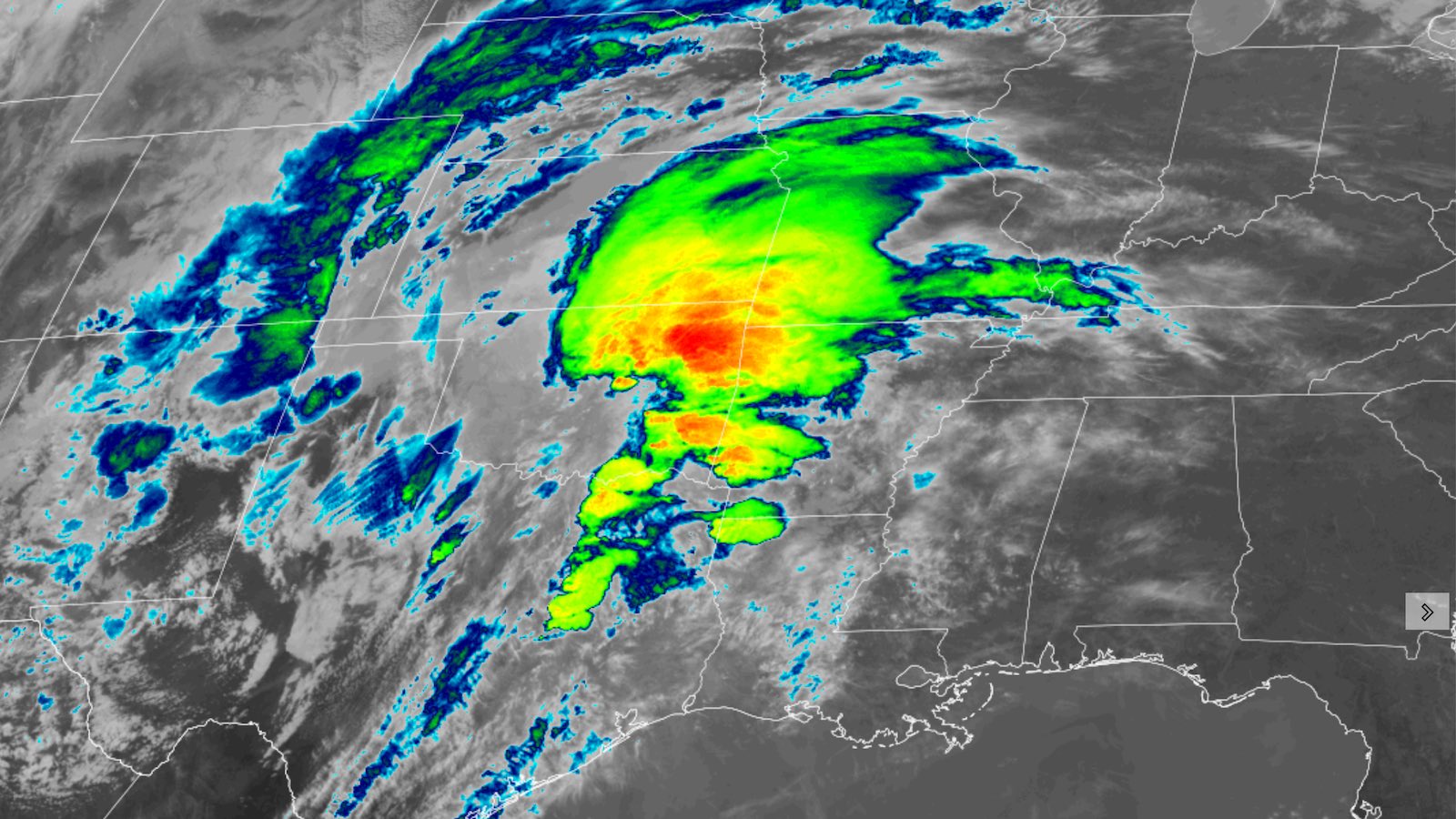
Central and eastern Texas were undergoing classic springtime weather whiplash on Monday. A strong warm front was bringing cloudy, damp, mild air from the Gulf in place of the sunny, dry air mass that had prevailed on Sunday, when strong south winds pushed multiple wildfires across the drought-parched landscape of Texas and Oklahoma.
As noted by SPC, the extensive clouds on Monday morning put a damper on the daytime heating that could intensify severe storms. However, they also allowed unstable air to flow into position relatively undisturbed – in effect setting the table.


One of the key factors for severe weather on Monday and Tuesday is the strength of a powerhouse upper-level low moving across the region. Fierce upper-level winds spinning around the low will lead to very strong vertical wind shear, which favors severe weather. Warm, moist low-level air should lead to more than enough instability.
However, the strong upward motion induced by the low may end up generating an intense thunderstorm squall line, rather than the more isolated supercells that produce the most violent tornadoes.
Therefore, it may be the first several storms that develop Monday evening in the Texas Triangle (the area between Dallas–Fort Worth, Austin–San Antonio, and Houston), and any isolated storms that form over southern Mississippi or Alabama well ahead of the expected squall line on Tuesday afternoon, that prove the most dangerous for strong long-track tornadoes (and potentially giant hail, especially on Monday). Nevertheless, damaging tornadoes are possible over the entire area outlined by SPC, and residents throughout should remain on guard.
Torrential rains can be expected with the main line of storms. Damaging straight-line winds will also be a concern, along with chances of brief line-embedded tornadoes.
A somber start to March
Tornado season tends to peak in late winter along the Gulf Coast, then migrate northward and westward through the spring into the central and northern Great Plains and Midwest by June and July. So the impending outbreak is hewing closely to the climatological playbook (unlike the Minnesota storm from March 2021 pictured in the tweet above).
This week’s outbreak is also consistent with the tendency of La Niña events to heighten the risk of severe weather in early spring, especially from the Southern Plains into the mid-South. We’re now in the second consecutive year of La Niña conditions.
It’s already been a tragic month for tornadoes, with seven people dying in Iowa on March 5. This localized outbreak included an EF4 tornado that struck central Iowa just south and east of Des Moines. It was one of the most intense tornadoes ever recorded so far north so early in the year, barreling across a track 69.5 miles long and up to 800 yards wide (almost a half mile) with estimated peak winds of 170 mph.


From 1991 through 2010, the United States saw an average of 7.6 tornado fatalities in March. But it’s one of the most variable months of the year for severe weather. In most years, nobody is killed by a U.S. tornado in March, but every few years there will be 20 or more tornado-related deaths (see graphic above).
Seven tornado fatalities were reported in March a year ago, but that month’s preliminary tornado count of up to 191 ranks second behind only the 192 twisters in 2017 in March records dating back to 1950.
Website visitors can comment on “Eye on the Storm” posts. Comments are generally open for 30 days from date posted. Sign up to receive email announcements of new postings here. Twitter: @DrJeffMasters and @bhensonweather
Source link