For the first time since the 2010s, a high-risk outlook for severe weather (level 5 of 5) has been issued for parts of the Great Plains. The outlook was put in place at 8 a.m. EDT Monday, May 6, and updated at 12:30 p.m. EDT Monday by the NOAA/National Weather Service Storm Prediction Center, as a busy few days of severe weather moved into high gear. Dozens of tornadoes could erupt by midweek, including in and near Oklahoma on Monday and across a broad swath of the mid-Mississippi and lower Ohio River valleys on Wednesday.
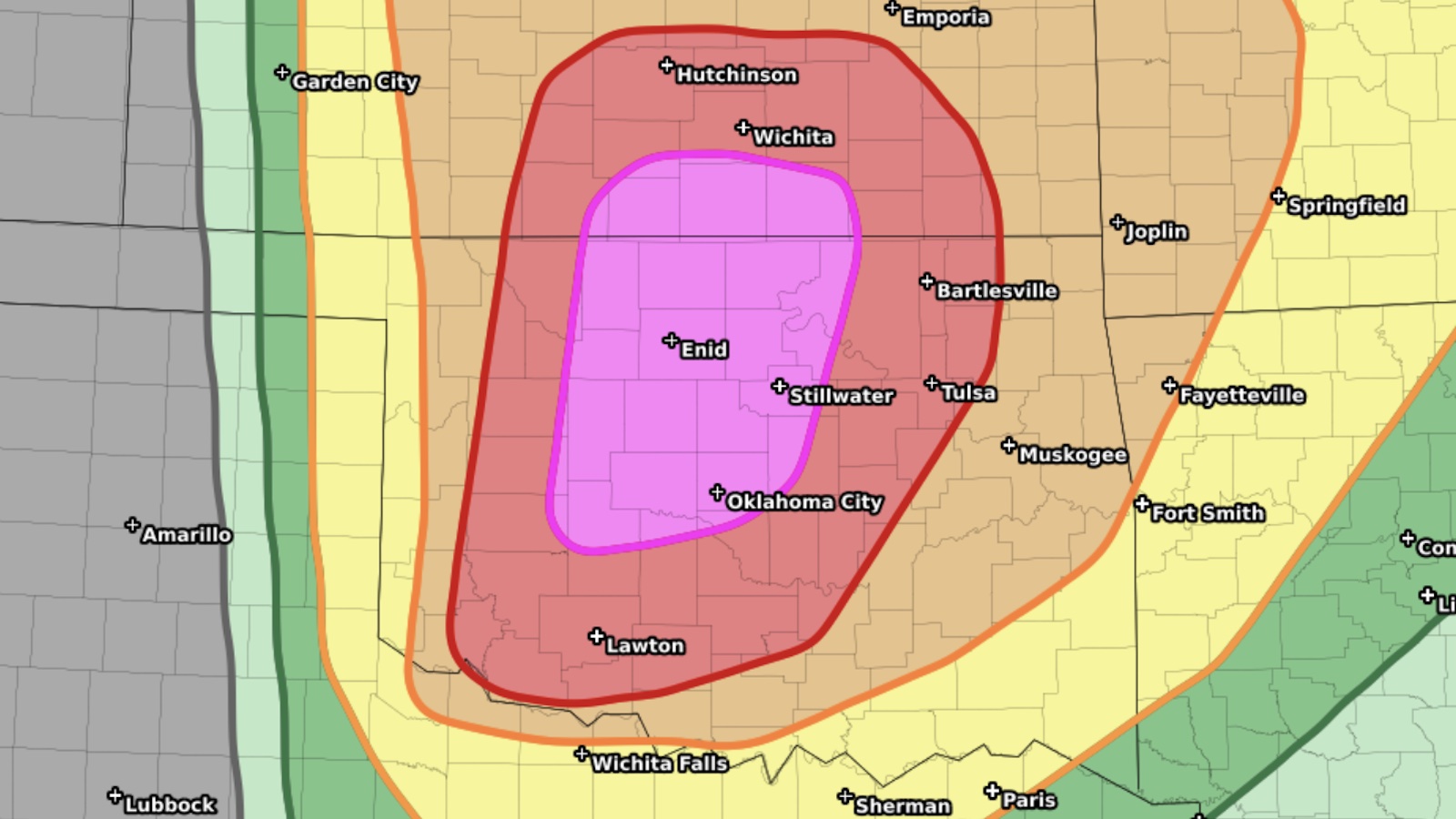
Much of Oklahoma and southern Kansas — including the cities of Oklahoma City, Tulsa, and Wichita — were included in the high-risk area.
Rick Smith, the warning coordination meteorologist for NWS/Norman, stressed in a tweet: “A couple of key messages: 1) most people will not see a storm, but if you do, it will probably be very bad; 2) the tornado potential will go UP after dark.”
Many of the worst tornado U.S. outbreaks of recent years have played out across the Mississippi Valley and Southeast, but multiple rounds of twisters have hammered the Plains since late April, taking at least seven lives and wreaking what will no doubt be hundreds of millions of dollars in damage. One late-night tornado in Oklahoma on April 27 was rated EF4 on the Enhanced Fujita Scale, and at least nine EF3 twisters have been recorded nationwide from April 26 through May 5.
Oklahoma’s preliminary tornado total for last month of 36 was the state’s second-highest on record for April, topped only by 44 in April 2012.
An ominous setup for Oklahoma and southern Kansas
The key ingredients for a top-end tornado outbreak were rapidly moving into place on Monday. Warm surface air with summerlike amounts of moisture (dew points of 70 degrees Fahrenheit and higher) was sweeping north from the Gulf of Mexico into Texas and Oklahoma, just as a potent impulse in the jet stream was barreling toward the Plains, bringing cold air aloft. That upper-level energy passed over Colorado in the predawn hours, pushing downslope wind gusts above 90 mph into the Boulder area late Monday morning.
The juxtaposition of muggy surface air and cold upper air will lead to extreme instability across Oklahoma, and strong west-northwest upper winds atop southerly surface winds will lead to ample wind shear for tornadic supercells producing giant hail (baseball to softball size). The initial storms will form along and ahead of a sharp dry line pushing into the high-risk region by late afternoon. Low-level wind shear may intensify further by evening, heightening the risk of strong after-dark tornadoes.
Even in storm-savvy Oklahoma, where severe weather is part of the backdrop of daily life, this outbreak could be a rare beast. Software developed at Saint Louis University that compares predicted conditions to those from past outbreaks pointed to some unsettling analogues, including the destructive outbreaks of April 26, 1991, and May 3, 1999.
One of the most eye-opening parts of the Monday setup is the extreme upper-level diffluence projected as the nose of the jet stream pushes into Oklahoma. The associated upper-level trough at this point has a strong negative tilt, meaning that it extends from northwest to southeast, and this is a hallmark feature of major U.S. tornado outbreaks.

As shown in Fig. 1, the jet stream winds will diverge dramatically across the high-risk area, making it easier for low-level air to ascend in thunderstorm updrafts. Moreover, the strong contrast in wind direction from surface to upper levels will help keep storms from interfering with each other, raising the odds of individual tornadic supercells that could persist for hours after dark.
The strong jet stream will remain in place across the central U.S. through midweek, so more severe weather is in the cards. The main threat on Tuesday is clusters of severe storms bearing heavy rain, strong winds, and hail across the Ohio Valley from southern Illinois and Indiana across northern Kentucky, but tornadoes are possible, according to the Storm Prediction Center Day 2 outlook issued early Monday for Tuesday.
As another strong upper-level impulse moves into the area on Wednesday, the atmosphere should have a chance to “reload,” and all modes of severe weather — including tornadoes, some possibly strong — will become a serious concern across an expansive area from Arkansas and southern Missouri into the Ohio Valley. The Storm Prediction Center issued an enhanced risk in its Day 3 outlook for Wednesday, and a more focused area of greater risk could emerge by then.
A couple of terms to watch for this week
“Violent tornado”: Many storm chasers and armchair chasers now refer to a tornado on radar or in video as “violent.” That adjective may fit in a layperson sense, but it has a more specific meaning for meteorologists: Only tornadoes rated EF4 or EF5 qualify as “violent.” Likewise, a “strong” tornado is one rated at least EF2, and an “intense” tornado is at least EF3. And as we’ve discussed in prior posts, those EF ratings are not assigned until after tornado damage has been surveyed and classified. One tornado in southwest Oklahoma on April 30 produced jaw-dropping radar imagery that wouldn’t have looked out of place for an EF5 tornado, but surveyors found no items that could confirm EF5 damage in the field that was struck, so it was rated EF1.
EF5: The top-end EF rating of EF5 corresponds to surface winds estimated at 200 mph or more. The last U.S. tornado rated EF5 struck Moore, Oklahoma, on May 20, 2013, so it’s been almost 11 years since then — the longest span free of F5 or EF5 tornadoes in modern U.S. record-keeping.
Jeff Masters contributed to this post.
We help millions of people understand climate change and what to do about it. Help us reach even more people like you.
Source link