Subtropical Storm Wanda formed in northern Atlantic late Saturday night, becoming the 21st named storm of the highly active 2021 Atlantic hurricane season. The season had gone eerily cold during October; prior to Wanda, the Atlantic had had no named storm activity since October 5, when Sam become post-tropical. Since the current active Atlantic hurricane period began in 1995, only one other year has had no named storm activity between October 6-30: the El Niño year of 2006. It is very unusual to see such a quiet October during a year when La Niña conditions are present, as is the case in 2021.
Wanda’s formation gives the 2021 Atlantic hurricane season 21 named storms, seven hurricanes, and four major hurricanes. The 1991-2020 averages for an entire season were 14.4 named storms, 7.2 hurricanes, and 3.2 major hurricanes.
The only Atlantic seasons with more named storms than 2021 were 2020 (30) and 2005 (28). The year 2020 had two named storms form after October: Tropical Storm Theta, and category 4 Hurricane Iota. In 2005, four named storms formed after October: Tropical Storm Gamma, Subtropical Storm Delta, Hurricane Epsilon, and Tropical Storm Zeta.
Wanda originated from a very unusual source: a nor’easter which brought heavy rainfall, damaging winds, and coastal flooding to parts of New England and the Northeast between October 25-27. The nor’easter caused at least $200 million in damage, according to Aon. It is uncommon for an extratropical storm to transition to a named storm, and it may be unprecedented for a damaging nor’easter to make the transition to a named Atlantic storm.
A “fish” storm called Wanda
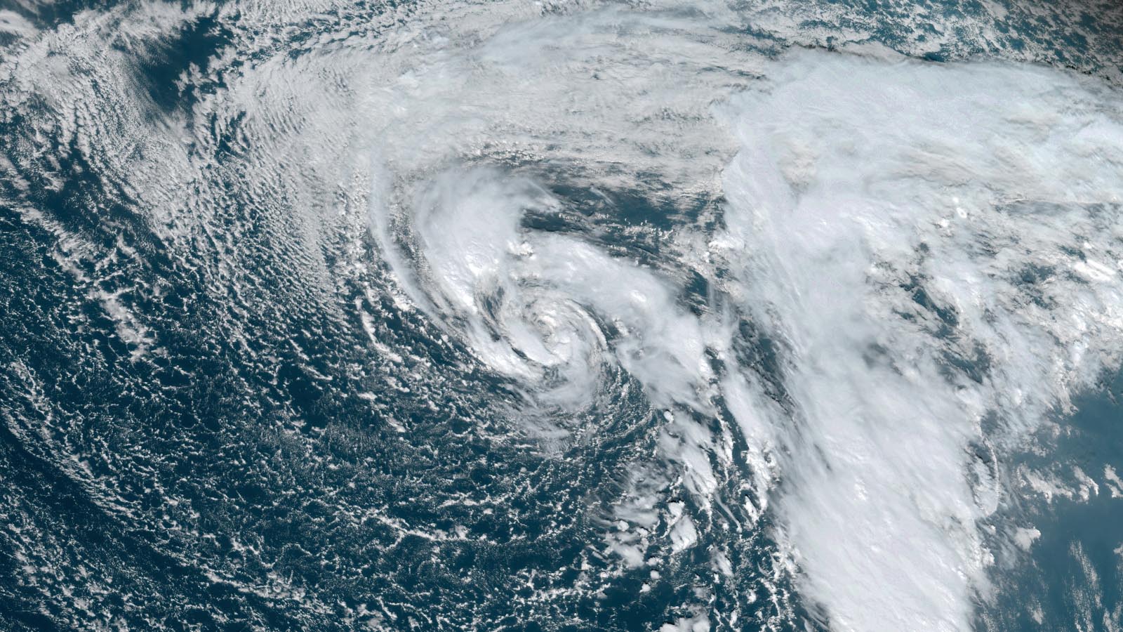
At 11 a.m. EDT Sunday, Wanda was located about 895 miles west of the Azores Islands, headed east at 8 mph with top sustained winds of 50 mph and a central pressure of 987 mb. Wanda was over chilly waters of 23 degrees Celsius (73°F), and was experiencing high wind shear of 20-30 knots. Wanda was embedded within an upper-level low pressure system, which was supplying very cold air aloft, creating high instability which allowed Wanda to generate the heavy thunderstorms needed to be classified as a subtropical storm.
Wanda is expected to move to the southeast Sunday night through Monday morning, which will carry the storm over warmer waters of 24 degrees Celsius (75°F). This may allow Wanda to make the transition from a subtropical to a tropical storm. The main factor that forecasters will be watching for is a transition from a cold core to a warm core, as suggested in analyses by Florida State University based on GFS model forecasts of Wanda.
By Tuesday, Wanda will be moving north to northeast over cooler waters, and by Friday, Wanda will be over cold waters of 18 degrees Celsius (64°F). These cold waters should make Wanda post-tropical by Saturday. Wanda’s projected path will keep it away from any land areas, making Wanda a “fish” storm, of concern only to marine interests.


A late-season Cabo Verde system could develop
An unusually late tropical disturbance in the eastern Atlantic, designated by the National Hurricane Center as 95L, could undergo some short-lived development over the next several days around a broad center of low pressure located a few hundred miles southwest of the Cabo Verde Islands. The system will be moving over warm waters (around 27-28 degrees Celsius, or 81-82°F) amid moderate wind shear (around 10-15 knots) in a moist surrounding environment (mid-level relative humidity of 60-70%).
Despite these modestly favorable conditions, 95L has only limited model support for development, and its 2 p.m. Sunday Tropical Weather Outlook, NHC gave 95L a 30% chance of developing into at least a tropical depression by Tuesday. Technically, the 5-day odds are also 30%, but 95L will be encountering cooler waters and much higher wind shear starting on Tuesday, so any development would likely occur before that point. Satellite images on Sunday afternoon showed that 95L was close to developing a well-defined surface circulation, but had only a limited amount of heavy thunderstorms near its center.
If 95L did manage to become a named storm, its name would be Adria – the first name on the new supplemental list adopted by the World Meteorological Organization and NHC in March 2021 in place of the Greek alphabet.
Many of the hurricanes that affect North and Central America originate from tropical waves moving off the coast of Africa into the eastern tropical Atlantic. Traditionally known as Cabo Verde-type systems, these storms can track across the Atlantic through the low-latitude area known as the Main Development Region. Historically, over 60% of all Atlantic hurricanes and 75% of all Atlantic major hurricanes have formed between August 20 and October 10, most of them from Cabo Verde-type systems. We are now well past peak Cabo Verde season, and typically by November, activity ceases in the far eastern tropical Atlantic.
Website visitors can comment on “Eye on the Storm” posts. Comments are generally open for 30 days from date posted. Sign up to receive email announcements of new postings here. Twitter: @DrJeffMasters and @bhensonweather
Source link