Subtropical Storm Nicole formed on Monday morning in the waters east of the Northwest Bahamas and is expected to intensify into a category 1 hurricane that will pass very near the northwestern Bahamas on Wednesday and make landfall in Florida on Wednesday night or Thursday morning. Because of Nicole’s large size and its arrival during the king tides, a damaging storm surge is likely along most of the Southeast U.S. coast from southern Florida to North Carolina. Storm surge watches were issued on Monday morning for a 400-mile stretch of the U.S. coast from southern Florida into Georgia.
Nicole’s formation on Nov. 7 comes almost two weeks before the average development date of the Atlantic’s 14th named storm of the year, Nov. 19, and brings 2022 to near-average for the number of named storms and hurricanes. This season’s activity now stands at 14 named storms, seven hurricanes, and two major hurricanes, with an Accumulated Cyclone Energy index of 78% of average for the date. The 1991-2020 averages for Nov. 6 are 13.7 named storms, 6.9 hurricanes, and 3.1 major hurricanes.
Nicole is a large storm – and that means widespread coastal flooding
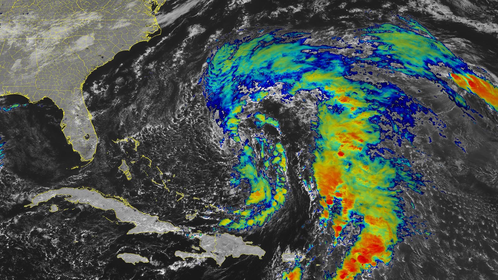
At 10 a.m. EST Monday, Nicole was centered about 495 miles east of the northwestern Bahamas, headed northwest at 9 mph, with maximum sustained winds of 45 mph and a central pressure of 1002 mb. Satellite images on Monday showed that Nicole had a distinctly subtropical appearance, with little heavy thunderstorm activity near its center, but a large area of heavy thunderstorms in a wide band arcing to the north and east of the center, which were bringing heavy rains to Bermuda. Nicole was already a large storm, with tropical-storm-force winds that covered a region of ocean about 350 miles in diameter.
Nicole had favorable conditions for development, with moderate wind shear near 10 knots and very warm ocean waters for this time of the year of 28 degrees Celsius (82°F) – about 1 degree Celsius (1.8°F) above average. However, there was plenty of dry air around the storm, associated with a decaying upper-level low-pressure system.


Track forecast for Nicole
Nicole will take a less-than-straightforward path over the next several days, winding its way generally westward but with some zigs and zags along the way. The key motion from Tuesday through Friday will be a broad anticyclonic loop around the strong upper-level high that will block Nicole from moving out to sea. This loop will take the center of Nicole west-southwest across the Northwest Bahamas on Wednesday, then west and west-northwest across the Florida Peninsula on Thursday. Depending on the exact positioning of the high by late week, it’s possible Nicole will reemerge over the northeast Gulf as a weaker system and make a second landfall in the Florida Panhandle around Friday before it rapidly recurves toward the northeast, moving off the Southeast coast by this weekend.
There’s high confidence at this point that Nicole will strike Florida from the east, but there is less certainty as to where it will move across the peninsula, as reflected in the divergent paths shown in the GFS ensemble graphic from early Monday (Figure 1). The ultimate path will be determined largely by the strength and configuration of the upper ridge by midweek. The most likely landfall location appears to be somewhere along the heavily populated stretch of coastline between Miami and Melbourne. As always, the highest surf, coastal flooding, and strongest winds will occur on the stronger right-hand side of the center, i.e., north of Nicole’s track.
Regardless of these details, the overall projected path makes it clear that the southeast U.S. Atlantic coast – especially from northern Florida to South Carolina – is in for several days of coastal flooding, given the large and prolonged fetch of onshore flow to the north of Nicole’s center together with the ongoing king tides. The general path will also ensure a widespread, multiday rainfall event by later this week, with 1-3 inches possible in many areas east of the Appalachians all the way to southeast New England. The heaviest totals will be just north of Nicole’s track in Florida and along and just inland from the Southeast coast.


Intensity forecast for Nicole
As Nicole heads west to west-southwest toward Florida on Tuesday and Wednesday, it will encounter moderate to high wind shear of 15-25 knots as strong upper-level winds out of the southwest from the subtropical jet stream affect the storm. There is dry air to the southwest of Nicole, and the dry air and wind shear are likely to prevent rapid intensification of the storm. The Monday morning suite of intensity model forecasts predicted that Nicole would make landfall in Florida with top sustained winds between 50 and 90 mph (i.e., as a strong tropical storm or category 1 hurricane). Given the large size of Nicole, and the somewhat unfavorable levels of wind shear and dry air, intensification into a category 2 hurricane is not expected.
Nicole is expected to bring a swath of 2-4 inches of rain along its path across Florida and northward into the Southeast U.S.; the dry air to Nicole’s southwest will likely limit rainfall over extreme South Florida. The St. Johns River, which winds through northeastern Florida to the north of Orlando, was still at moderate flood stage this week because of Hurricane Ian’s rains at the end of September. Nicole’s rains are predicted to cause the river to rise again (Figure 4). Nicole’s rains will help alleviate drought in some portions of the Southeast U.S. coast, though (Figure 3).


The king tides are here
The arrival of the full moon on Tuesday will bring some of the highest tides of the year – the king tides. Minor coastal flooding was observed at multiple locations along the coast of Florida during the morning high tide on Sunday and Monday because of the king tides, and coastal flooding at high tide will increase this week as the onshore flow in advance of Nicole drives a storm surge in excess of two feet along a large portion of the Southeast U.S. coast. The high tides between 7 and 9 a.m. EST Tuesday and Wednesday will be particularly elevated from the king tides, and the odds of coastal flooding will be increased at those times.

Nicole will generate high waves
Coastal damage will be especially high just to the north of where Nicole’s center crosses the coast; waves offshore there are predicted to reach 30 feet (see Tweet above). High waves on top of a large storm surge at high tide during the king tides are a recipe for significant coastal damage and beach erosion.


November landfalling storms are rare in the U.S.
According to the NOAA hurricane database, 10 tropical storms and three hurricanes have made landfall in the continental U.S. in November or December since records began in 1851 – an average of one late-season landfall every 13 years. (This doesn’t count another tropical storm, Juan of 1985, which made landfall on Oct. 31 in Alabama, but was still a tropical storm while inland over Alabama on Nov. 1). The most recent late-season landfall was Tropical Storm Eta, which hit near Cedar Key, Florida, on Nov. 12, 2020. The two strongest late-season landfalls were category 2 hurricanes with 100 mph winds at landfall – Hurricane Kate, which hit the Florida Panhandle on Nov. 21, 1985; and the Yankee Hurricane of 1935, which hit just north of Miami Beach on Nov. 4. The latest landfalling contiguous U.S. storm on record was an unnamed tropical storm with 65 mph winds that hit just south of Fort Myers Beach, Florida, on December 1, 1925.
An east-to-west track into Florida for a tropical or subtropical storm in November is very unusual: In fact, it has only occurred once on record, during the Yankee Hurricane of 1935, which made landfall in northern Miami Beach as a category 2 hurricane with 100 mph winds on Nov. 4.
Disturbance 97L may yet develop
Invest 97L is in the central Atlantic a few hundred miles to the northeast of Nicole. This system is benefiting from the exceptionally warm waters for so late in the season that prevail across much of the northwest Atlantic. Sea surface temperatures at this latitude – poleward of 30 degrees north – are running around 25.5 degrees Celsius (78°F), just below the usual threshold for tropical development, and more than 1 degree Celsius (1.8°F) above average. However, westerlies at the jet-stream level are shrieking above 97L, bringing over 50 knots of wind shear. This shear is pushing convection well east of the center as soon as it forms and leaving the center a naked swirl. Moreover, the atmosphere surrounding 97L is quite dry, with a midlevel relative humidity around 50%.
Wind shear is expected to drop to 30-40 knots on Tuesday over 97L, giving the system a brief window of time to develop into a tropical storm before it moves over cooler waters of 24 degrees Celsius (75°F) on Tuesday night. In its 7 a.m. EST Monday Tropical Weather Outlook, the National Hurricane Center gave 97L 2-day and 5-day odds of development of 60%. The system is not a threat to any land areas.
Website visitors can comment on “Eye on the Storm” posts (see comments policy below). Sign up to receive notices of new postings here.
Source link