| Mesoscale Discussion 998 | |
| < Previous MD | |

|
|
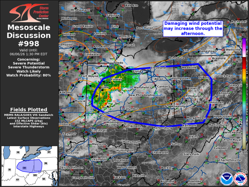
   Mesoscale Discussion 0998
   NWS Storm Prediction Center Norman OK
   1007 AM CDT Sat Jun 06 2026

   Areas affected...eastern Ohio...western Pennsylvania...northern West
   Virginia...and northern Maryland

   Concerning...Severe potential...Severe Thunderstorm Watch likely

   Valid 061507Z - 061730Z

   Probability of Watch Issuance...80 percent

   SUMMARY...Thunderstorm activity to increase in coverage and
   intensity through the late morning/afternoon with an increase in
   damaging wind potential.

   DISCUSSION...A line of storms continues south and east across
   portions of eastern Indiana into Ohio, with occasional strong to
   isolated severe gusts (50-60 mph). It is uncertain how this will
   evolve downstream, with guidance showing potential for maintenance
   and intensification along the remaining outflow later in the
   afternoon. Gradual increase in forcing for ascent will occur this
   afternoon as strengthening mid-level flow overspreads the area with
   the trough across the Great Lakes. Filtered heating is expected
   through broken mid-level cloud cover. This in combination with dew
   points in the low to mid 60s will yield around 1000-1500 J/kg
   MLCAPE. Additionally, steepening low-level lapse rates are expected,
   supporting downward transport of higher momentum flow aloft to the
   surface. Additional downstream development is likely with potential
   for several clusters of storms capable of damaging wind through the
   afternoon. While exact timing of this threat remains uncertain, a
   watch will likely be needed to cover this potential by the
   afternoon.

   ..Thornton/Thompson.. 06/06/2026

   ...Please see www.spc.noaa.gov for graphic product...

   ATTN...WFO...CTP...LWX...PBZ...RLX...CLE...ILN...IWX...

   LAT...LON   39388094 39598308 39778367 40128449 40428451 40718435
               41138399 41408307 41498278 41707930 41127867 40497870
               39977880 39517912 39388094
|
|
|
Top/All Mesoscale Discussions/Forecast Products/Home |
|
Source link