|
|
| Mesoscale Discussion 992 | |
| < Previous MD Next MD > | |

|
|
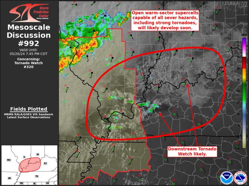
Mesoscale Discussion 0992 NWS Storm Prediction Center Norman OK 0618 PM CDT Sun May 26 2024 Areas affected...Far Southeast MO...Far Southern IL...Western/Central KY...Far Southwest IN Concerning...Tornado Watch 320... Valid 262318Z - 270045Z The severe weather threat for Tornado Watch 320 continues. SUMMARY...Open warm sector initiation appears to be underway from far southeast Missouri across far southern Illinois into western/central Kentucky and southern Indiana. Supercells capable of all severe hazards, including strong tornadoes, are possible. Southern IN and western/central KY will likely need an additional Tornado Watch soon. DISCUSSION...Recent visible satellite has shown increasingly deep cumulus within the warm sector well ahead of the main cold front from far southwest MO across southern IL into southwest KY and far southwest IN. Some radar returns have been recently noted with this activity as well, giving increasing confidence that at least isolated convective initiation may be realized shortly. A belt of stronger mid-level flow extends across much of this region, resulting in notable low-level veering within the VAD profiles at PAH and HPX. Ample low-level moisture and strong buoyancy exists across the region as well. Mesoanalysis estimates STP is currently from 3 to 5, with this high values expected to persist and expand northeastward with time. The result is an environment that is favorable for supercells capable of all severe hazards, including strong tornadoes. Very large hail up to 2.5" in diameter is possible as well. Some of this area is within the Tornado Watch 230, but those areas to its east including far southern IN and western KY will likely need an additional Tornado Watch soon. ..Mosier/Smith.. 05/26/2024 ...Please see www.spc.noaa.gov for graphic product... ATTN...WFO...LMK...IND...PAH...ILX... LAT...LON 38128933 38648795 38618586 36998615 36568934 37308980 38128933 |
|
|
Top/All Mesoscale Discussions/Forecast Products/Home |
|


