| Mesoscale Discussion 987 | |
| < Previous MD | |

|
|
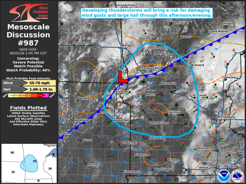
   Mesoscale Discussion 0987
   NWS Storm Prediction Center Norman OK
   0112 PM CDT Fri Jun 05 2026

   Areas affected...portions of northeastern South Dakota into central
   Minnesota

   Concerning...Severe potential...Watch possible

   Valid 051812Z - 051945Z

   Probability of Watch Issuance...40 percent

   SUMMARY...Scattered thunderstorms developing near the ND/SD/MN
   border will bring the potential for damaging wind gusts and large
   hail as they progress east-southeastward this afternoon. Trends are
   being monitored for possible watch issuance.

   DISCUSSION...Latest GOES visible satellite imagery depicts
   increasingly agitated cumulus in close proximity to a weak surface
   low analyzed near the ND/SD/MN border, with recent lightning
   activity noted with a developing thunderstorm in Wilkin County, MN.
   Continued heating of a moist, low-level air mass (dewpoints in the
   60s F) is supporting around 1000 J/kg MLCAPE, with further
   destabilization likely to support 1500-2000 J/kg by peak heating
   this afternoon. Compared to areas farther east, effective shear is
   marginally greater across this region, with 30-35 kts analyzed per
   latest objective analysis. Modest mid-level lapse rates (6.5-7.0
   C/km per latest mesoanalysis) will support some potential for large
   hail with initially discrete convection, with steep low-level lapse
   rates also promoting a threat for damaging wind gusts.

   With time, expectation is for this activity to organize along
   developing cold pools into one or more bowing segments/convective
   clusters, with some increase in the threat for damaging wind gusts
   possible. Trends are being monitored for possible watch issuance.

   ..Chalmers/Mosier.. 06/05/2026

   ...Please see www.spc.noaa.gov for graphic product...

   ATTN...WFO...DLH...MPX...FGF...FSD...ABR...

   LAT...LON   46269414 45699396 45209393 44889401 44629427 44519467
               44529548 44669633 44809684 45119736 45379745 45719736
               46459664 46849616 46999590 46979528 46809482 46649461
               46269414

   MOST PROBABLE PEAK WIND GUST...55-70 MPH
   MOST PROBABLE PEAK HAIL SIZE...1.00-1.75 IN
|
|
|
Top/All Mesoscale Discussions/Forecast Products/Home |
|
Source link